Elevation: 9,758 ft
Prominence: 738
This peak is not in the book. Judi Steciak provided the first entry based on her 2023 climb. Judi recommends the name “Peace Sign Peak.” Rick Baugher suggests the name “Jaywalk Peak.” Livingston Douglas added the 2024 entry. Livingston’s entry is more detailed and covers the first leg of a 3-peak adventure that includes Peak 9758, Peak 9593, and Peak 9785. His trip covers 7.5 miles with 4,125 feet of elevation gain round trip. Updated December 2024
Peak 9758 is located 2.2 miles north of Estes Mountain. It can be climbed from Loon Creek Summit or from the vicinity of Estes Mountain. Climbing this peak combines a nice ridge walk with fine views of the surrounding mountains. The peak boasts a huge peace sign constructed from deadfall. One could speculate that it has been there since the 1960s. USGS Custer
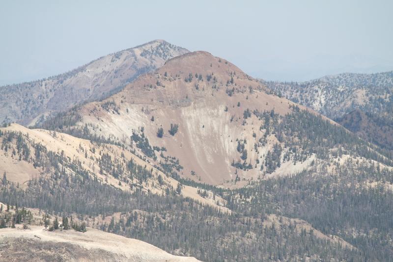
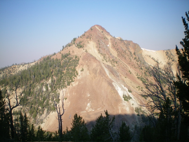
Peak 9758 as viewed from Mount Greylock
2023 Trip Report by Judi Steciak
Access
Park at Loon Creek Summit [(F)(3.2) Page 172]. The Loon Creek Summit Trail, FST-172 begins behind the kiosk on the southeast side of the pass. Remnants of this long abandoned trail can still be found in places. Persevere around some blowdown as the trail snakes southeast then east up bumps on the ridge that forms the border of the Frank Church-River of No Return Wilderness. The trail peters out as the ridge approaches Point 9400+. Continue walking the ridge as it bends sharply north. The ascent of the peak’s southwest ridge begins at this point.
Southwest Ridge, Class 2+
Footing on this ridge is generally good until the last 300 feet of the summit cone. Bypass the major tower on the right (southeast side). Above this, there is slightly better footing (with mild exposure) for a short ways on the crest. Walk along the base of the summit rooster comb until you can scramble up a short wide gully to the cairn.
The peace sign is located on the northwest slopes of the bump north of Point 9400+. To the disappointment of the folks (or aliens trying to send earthlings a message) who put so much effort into arranging the deadfall, the sign is not visible from the parking area and it is easy to walk by. It is best spotted during the descent from the summit or from outer space.
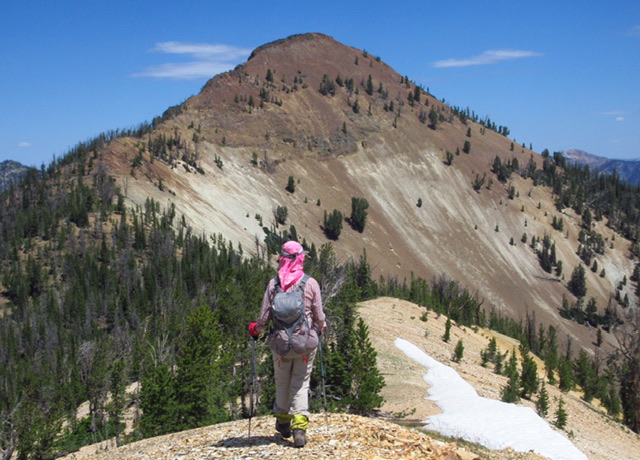
Approaching the southwest ridge. Judi Steciak Photo
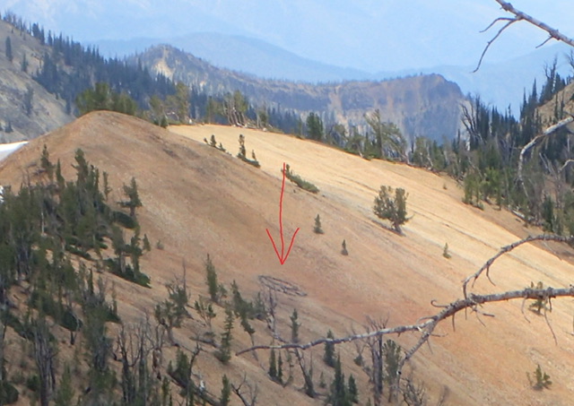
The peace sign. Judi Steciak Photo
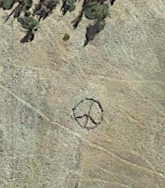
A view from space. Courtesy of NASA
2024 Entry by Livingston Douglas
Peak 9758 and its steep, rocky east ridge (center). This was my descent route. Livingston Douglas Photo
Peak 9758 is a ranked summit that sits on a high ridge that separates the Eightmile Creek drainage from the Mayfield Creek drainages. This ridge begins at Loon Creek Summit and extends northeast to Peak 9539 and includes six ranked summits. Peak 9758 is most easily climbed from Loon Creek Road to its west. USGS Custer
Access
From Yankee Fork Road/FSR-070, drive north up Loon Creek Road/FSR-172. At 6.0 miles, reach a signed junction with FSR-356. Go right to stay on Loon Creek Road. Drive up the steep switchbacks to reach Loon Creek Summit at 9.0 miles. Continue north on the road as it descends into the West Fork Mayfield Creek Valley. At 10.3 miles, reach a roadside pullout just before the road makes a sharp left/north turn to follow the West Fork Mayfield Creek. Park here (8,170 feet and 44⁰28’02”N, 114⁰43’49”W). This is the first leg of a 3-peak adventure that includes Peak 9758, Peak 9593, and Peak 9785. It covers 7.5 miles with 4,125 feet of elevation gain round trip.
West Face/South Ridge, Class 2-3
The Climb
From the roadside pullout, walk a short distance down the road to the sharp left/north bend (no pullouts at the bend). Leave the road and stay left/north of a mess of downed pines (avalanche debris) on the south/southeast side of the road bend. Bushwhack up the left/north side of a dry drainage on a forested shoulder (of sorts) that becomes a face. Head east up the steep, forested west face of Peak 9758 in between a massive white scree field to the left/north and a light brown scree field to the right/south. The forested bushwhack up the face is on firm grave/duff initially but about midway up it becomes pretty steep. The underlying gravel is relatively firm but there are a few loose sections.
Angle diagonally left/northeast high up to intercept the ridge saddle (9,220 feet). The ascent up the west face has its share of downed timber but there is no understory to contend with. From the ridge saddle, bushwhack north then northwest then northeast to the rocky summit. The ridge looks intimidating but it’s not bad. Stay on the narrow, rocky ridge crest (initially it is easy pine forest). There are a few Class 3 moves (especially higher up), but they can be avoided on the steep, loose scree on the sides of the ridge. The summit of Peak 9758 has a decent summit cairn.

Peak 9758 (summit is right of center) and its rocky south ridge (center and left of center). The south ridge was my ascent route. Livingston Douglas Photo
East Ridge, Class 3
The Descent
From the summit, descend east then east-northeast on a steep, loose mess of rocky ridge outcrops and rock strata with very loose scree/gravel in chutes amongst the ridge rock. Stay right/south of any ridge breaks. You can use a gapped pine forest to the right/south of the ridge crest midway down as an alternative but it’s no picnic either. It has steep, loose scree for much of its base. Downclimb a final slope of steep-ish talus/scree to reach a forested, flat saddle with no talus/scree. This 8,980-foot saddle is the connecting saddle between Peak 9758 and Peak 9593. It concludes the first leg of today’s 3-peak journey. Peak 9593 is up next.
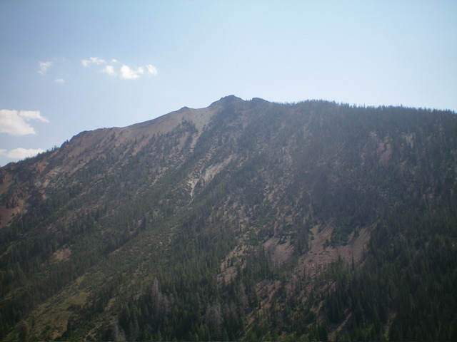
Peak 9758 as viewed from Loon Creek Road to its west. Livingston Douglas Photo
Additional Resources
Regions: Eastern Salmon River Mountains->Salmon River Mountains->Southeast Corner Peaks->WESTERN IDAHO
Mountain Range: Salmon River Mountains
Longitude: -114.71869 Latitude: 44.47579