Elevation: 7,451 ft
Prominence: 901
This peak is not in the book. Published November 2020
Sheep Mountain is a big, forested mountain on the southwest side of Long Valley, southeast of Bone, ID. This area is a mix of BLM land and private ranch land. The upper part of this climb is on private land but I encountered no fencing, orange paint, or signage to prohibit entry. This is a difficult area to bushwhack, including the brushy, open summit ridge. Not fun stuff. USGS Long Valley
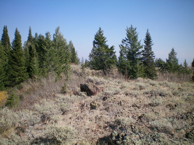
The summit high point of Sheep Mountain. Livingston Douglas Photo
Access
From the South:
The [signed] junction of ID-34 and West Side Road (just a simple street sign) is located just east of where westbound ID-34 makes a SHARP turn left/south to head down to Blackfoot Reservoir and Soda Springs. At this junction, turn right/north onto West Side Road and drive 8.9 miles north to a [signed] “T” junction at the northwest corner of Grays Lake. Turn left/west onto Grays Lake Road (which becomes Long Valley Road) and follow it for 10.6 miles to an unsigned BLM road on the left/southwest side of Long Valley Road.
From the North:
From the junction of Long Valley Road and Blackfoot Reservoir Road (about a mile south of Bone, ID), drive southeast on Long Valley Road for 10.6 miles to reach an unsigned BLM road on the right/southwest side of Long Valley Road. This BLM road is also 19.3 miles south of the junction of Bone Road and Sunnyside Road, southeast of Idaho Falls. Bone Road becomes Long Valley Road as you head south from the Idaho Falls area.
The junction of Long Valley Road and the unsigned BLM road is shown on the USGS topo map just northwest of “Gold Spring” and has a point measurement of 6,354 feet on the map. The USGS topo map shows the old road heading south up the west side of a gully, which it does. However, the road continues farther up the northeast side of Sheep Mountain in a series of switchbacks.
This road section does NOT show up on the USGS topo map so it is a bit confusing to encounter these switchbacks higher up, not knowing where the road is going. No, unfortunately, the road does not lead to the summit of Sheep Mountain. Park at the base of the BLM road (6,355 feet) because it is gated and closed a short distance above its junction with Long Valley Road.
Northeast Gully/Northeast Face, Class 2
The Climb
This route follows the northeast gully, which is the gully that the old BLM road heads up. Most of this climb is a difficult, tedious bushwhack up that gully or on a nearby face. From Long Valley Road, hike up the 2-track BLM road as it quickly weakens and becomes difficult to follow, particularly through open meadows early on. Stay on the right/west side of the gully at all times. The old road crosses to the left/east side of the gully at about 6,600 feet.
The gully bends noticeably right/southwest here. Not knowing where the road is going, leave the road here and follow the right side of the gully, using cattle/game trails whenever possible. The forest here has a lot of blowdown and the steep side-hilling is difficult. Bash your way up the gully until it morphs into a face. The gully actually re-emerges higher up if you head left/south here and the gully climbs to the ridge crest at a saddle just west of Point 7135 (this was my descent route).
When the gully morphs into a face, continue heading southwest up the steep, forested slope to reach the open summit ridge much higher up. This is a punishing, merciless bushwhack through thick forest, endless blowdown, and brush. You will rue the day that you ever had the idiotic idea to do this route. When you reach the ridge crest, it is only a short bushwhack in open terrain up the east ridge to reach the summit high point. You will even find a cattle trail on the ridge crest through the thick sagebrush.
The USGS topo map indicates the high point as 7,451 feet and at the west end of the summit ridge area. But there was nothing on top. However, there is another summit hump nearby (to the east-southeast) that appears to be of equal height and has a cairn atop it. Might it be the true summit of Sheep Mountain? Well, let’s check it out.
I passed near this point on my way up the east ridge, so returning to it was [kind of] on my way back down the east ridge anyway. It turns out that the [lower] east summit is identical in height according to my altimeter. It has a nice summit cairn and is a bit easier to reach than the [measured] west summit. Stand on both potential summits just to be sure. Personally, I would still vote for the [measured] west summit on this one.
Looking east-southeast at the east summit from the true summit. Is that a higher hump? Livingston Douglas Photo
Looking west-northwest at the west summit of Sheep Mountain (left of center) from the east summit. Which one is higher? Livingston Douglas Photo
East Ridge/Northeast Gully, Class 2
The Descent
Navigationally-speaking, you simply MUST find the northeast gully in order to find your way back to the BLM road and your parked vehicle. The USGS topo map indicates that the gully actually reaches the east ridge at a minor saddle just west of Point 7135. From the summit, follow a cattle trail through the thick brush, sagebrush, and scattered pines on the east ridge to reach that small saddle. There is a final short patch of pine forest to bushwhack through to reach the saddle.
From the saddle, leave the ridge and follow the [ill-defined] gully north-northwest (briefly) down through thick pine forest. Then descend north and stay in (or close to) the gully as it bends right-ish/northeast to get back down to the BLM road. Use cattle trails in the gully to expedite the descent. Thanks to the cattle trails, this was a much faster route than the ascent route. Once you reach the BLM road (where it crosses the gully), follow it back down to Long Valley Road and your parked vehicle.
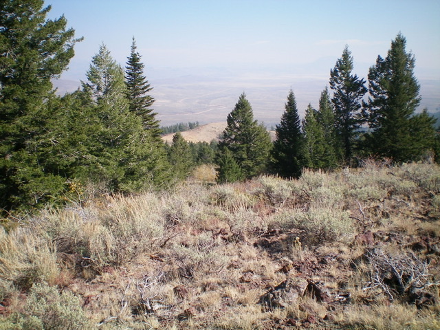
Looking down the east ridge of Sheep Mountain from near the summit. Livingston Douglas Photo
Additional Resources
Regions: Caribou Range->SOUTHERN IDAHO
Mountain Range: Caribou Range
Longitude: -111.67949 Latitude: 43.19809