Elevation: 9,682 ft
Prominence: 2,302
Climbing and access information for this peak is on Page 365 of the book. The access information in the book is no longer accurate as the roads and trails described therein have changed over the years. The updated information from Livingston Douglas (found below) will get you current. Updated February 2021
Sherman Peak is the 67th-most prominent peak in Idaho. USGS North Canyon
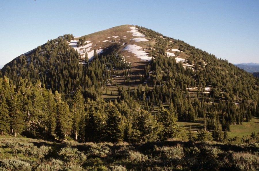
Sherman Peak as viewed from the north.
2018 Update by Livingston Douglas
Sherman Peak is a behemoth. It is the highest peak in the Bear River Range and stands as a sentinel overlooking the north end of the Bear River Valley.
- The Eightmile Campground has been out of service for years (“disused” as the Brits would say). It is accessible but is in rough shape. The campsites are overgrown and the road surface is breaking up. There is no sign for it either but it IS there. I actually camped at the first campsite, which has a decent parking area and two large trees for shade.
West Face/North Ridge, Class 2
Access
From the junction of US-30 and South 3rd Street in Soda Springs, drive south on South 3rd Street, which becomes Eightmile Road. At 6.4 miles, turn right at an unmarked junction (the road going straight is gravel, not paved). At 7.8 miles, the pavement ends. At 10.0 miles, enter the Cache National Forest and the road becomes FSR-425/Eightmile Canyon Road. At 11.5 miles, go straight at a road junction on FSR-425. At 13.4 miles, the road passes the site of the old Eightmile Campground. At 13.8 miles, reach a signed junction with FST-446 on the LHS of the road. FST-446 is an ATV/MC trail. Park at this trailhead or, if the road is too rough for your vehicle, park at the site of the old Eightmile Campground and hike up to the trailhead. The elevation at the trailhead is approximately 6,860 feet.
The Climb
Please note that the USGS topo map for Sherman Peak is wildly inaccurate with respect to road/trails on this mountain. The map fails to show FST-446 and FST-317. It does accurately show Skinner Canyon Road/FSR-403 but it also shows two other jeep road/trails which do not exist (one on the north side of the mountain and one on the south side of the mountain).
From the junction of Eightmile Canyon Road/FSR-425 and FST-446, hike eastward up FST-446 (an ATV trail) for just over a mile to a point where the trail turns left/north and begins to descend. The elevation here is 8,260 feet. This departure point is on the northwest side of Point 8522. Bushwhack east up through aspens and blowdown onto a shoulder that leads up to the west side of Point 8522. Skirt the right/west side of Point 8522 in open terrain with reasonable side-hilling. When the open terrain turns into forested terrain, look for a game trail to follow left/southeast up over a minor saddle at the base of the south ridge of Point 8522. You are now on the north ridge of Sherman Peak.
Bushwhack south across a meadow then follow the ridge crest southeast for a brief section. The ridge bends right/south and continues in a southward direction all the way to the summit. You will find a game trail, on and off, near the ridge crest. Skirt the right/west side of Point 9366 just below the forest line. Return to the ridge crest on a nice, diagonally-upward game trail. The open terrain on the north ridge is mostly grass, but there are some sections of sagebrush and other desert scrub (sometimes thick) to navigate through.
The saddle between Point 9366 and the summit is wide and open (easy field grass). Once past the gentle saddle, follow a weak game trail up through a short section of easy forest. The forest disappears and, from here, it is easy open terrain to the summit. Stay on the left/east side of the ridge crest for the easiest going (on a combination of scree and short scrub). The summit of Sherman Peak has a massive, wide cairn (a rock pile, really) and a USGS benchmark in a nearby ground boulder. It also has a tall wooden post and an old wooden Forest Service communication box with a rusty metal phone structure/case inside. The communication box is secured to a steel post. The views from the top are magnificent.
South Ridge (Descent), Class 2
Access
Same as for the west face/north ridge. This descent is part of a ridge traverse from Sherman Peak to Peak 9212. The easier, more direct access to the south ridge is via Skinner Canyon Road/FSR-403, which skirts the east side of the base of Sherman Peak’s south ridge in an open meadow at 8,800 feet.
The Descent
From the summit, descend the south ridge (more of a face initially) on a mix of gravel/scree, short scrub, sagebrush, and scattered trees. This descent is a bit loose initially. You will find a game trail near the ridge crest to help you in your descent. The terrain is more open on the left/east side of the ridge crest, but is rockier and more angled there, so stay near the ridge crest or on its right/west side. The forest on the right/west side is relatively open and is not too thick.
After crossing a minor saddle at 9,317 feet, ascend 40 feet (vertical) up over a ridge hump. From this hump, descend south rapidly to the more important, and lowest, saddle between Sherman Peak and Peak 9212. The terrain in this section of the descent is a mix of forest and open veg. A game trail will help expedite your descent. This saddle is relatively narrow and has a large open meadow on its east side. Skinner Canyon Road cuts through the open meadow but does NOT cross the saddle. The elevation at this saddle is 8,780 feet. This is the base of the south ridge of Sherman Peak.
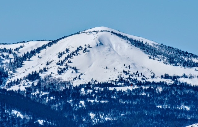
Sherman Peak, February 2021. If you look closely you will see a large avalanche scar on the left side of the photo. This avalanche killed a snowmobile rider. Russ Durrant Photo
Additional Resources
Regions: Bear River Range->SOUTHERN IDAHO
Mountain Range: Bear River Range
Year Climbed: 1990
First Ascent Information:
- Other First Ascent: West Face/North Ridge
- Year: 2018
- Season: Summer
- Party: Livingston Douglas