Elevation: 8,603 ft
Prominence: 583
This peak is not in the book. Published January 2023
Stump Peak is the namesake peak in this section of the Webster Range. While not quite the highest peak, it doesn’t miss by much (only two feet). Stump Peak is on a high ridgeline that separates Lanes Creek from Stump Creek. It is most easily reached from FST-022 or FST-117 to its north. Private land in this area makes it difficult to drive close to Stump Peak. USGS Stump Peak
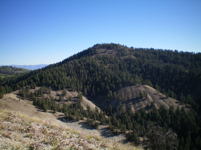
Stump Peak as viewed from Point 8268 to its southwest. The ascent route (southwest ridge) climbs from the bare saddle at left up and diagonally right to the semi-forested summit. Livingston Douglas Photo
Access
From ID-34 east of Wayan, turn left/south onto [signed] Lanes Creek Cutoff Road. This road is a smooth, well-maintained dirt/gravel county road. Head south on Lanes Creek Cutoff Road for 3.1 miles to an unsigned junction with the Lander Cutoff Road/FSR-107. Turn left/east onto FSR-107 and drive a short distance, cross a small creek on a bridge, and reach BLM land (a short patch) then enter the Caribou National Forest. After driving 6.0 miles on FSR-107, park alongside the road at a pullout that is located just before reaching a crossing of Flat Valley Creek (7,225 feet). GPS coordinates: 42⁰53’13”N, 111⁰13’57”W. FSR-107 is a decent, but narrow, road with potholes and some ruts. It is not “well-graded” as some suggest.
Southwest Ridge, Class 2
The Climb
From the roadside pullout, walk about 50 yards southeast on FSR-107 to reach the north side of Flat Valley Creek., a wide drainage with lots of willows and marsh here. Find an initially-weak use trail in the field grass on the left/north side of the creek drainage. Follow this trail up into the forest. The trail later drops to creekside then heads diagonally back up onto the ridge on the left/north side of Flat Valley Creek. Continue along the use trail as it drops to the large marsh at the toe of the shoulder (or descend left/north on a use trail to more gently reach the triangular-shaped marsh area at a spot farther to the north).
This marsh is tricky because it’s not obvious where the water is, but it’s there and there are some large beaver ponds hidden in the brush. Cross the marsh at its south end (either in or near the forest) to reach the open terrain (mica schist) at the toe of the southwest ridge of Stump Peak. The approach hike is over. From the marsh (7,000 feet), climb up a STEEP section (about 350 vertical feet) of somewhat-loose schist gravel, staying near scattered pines for the best footing. The slope eventually eases and a decent game trail emerges on the ridge crest. Scramble up the forested ridge crest northeast then move east onto a nearby ridge at 7,600 feet to reach the top of a ridge hump (Point 7760+) just above a visible ridge saddle. Drop 35 vertical feet to a minor saddle then climb up another steep section of open terrain (loose mica schist).
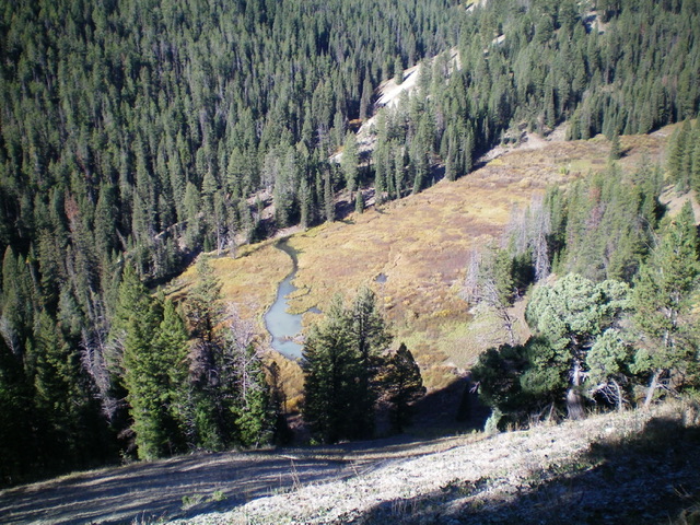
Looking steeply down at the critical marsh at the base of the southwest ridge. Navigating across it is tricky.
The ridge bends left/north to reach semi-open Point 8268 on an elongated ridge crest area. You can now see Stump Peak (mostly forested) to the right/northeast. A game trail helps in this entire area. Descend steeply north (initially) from Point 8268 on loose rock/schist with scattered pines and blowdown. The ridge bends right-ish/northeast to reach the easy scrub and broken rock of a narrow connecting saddle. From the end of the saddle, bushwhack east up through the pine forest on a game trail then finish with a steep push up open scrub with a schist base to reach the semi-open summit of Stump Peak. Nearby pines obscure some of the views. The summit has a benchmark but no summit cairn, so I built a modest one.
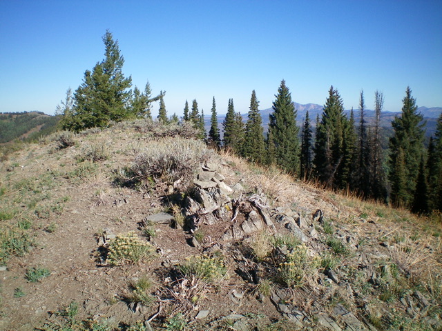
The summit of Stump Peak with its newly-built summit cairn. Livingston Douglas Photo
Additional Resources
Regions: Peale Mountains->SOUTHERN IDAHO->Webster Range
Mountain Range: Peale Mountains
Longitude: -111.1899 Latitude: 42.9014