Elevation: 7,649 ft
Prominence: 1,029

This peak is not in the book. The original entry recounted the peak’s history as a fire lookout. Livingston Douglas added all the additional details. Updated November 2023
Ulysses Mountain is located northwest of North Fork, Idaho and due south of Indian Peak. Ulysses Mountain is the high point on a ridge that separates Indian Creek from Sage Creek in the Bitterroot Mountains. It has a metal fire tower on top and a few old sheds. Ulysses Mountain can be reached via a service road to the summit area but the road gets rocky and rough as you approach the summit. The summit is open and offers magnificent views of the surrounding area. USGS Ulysses Mountain
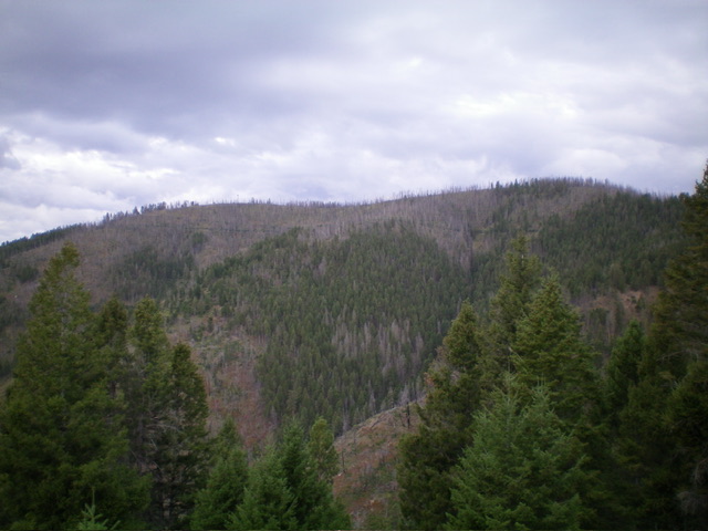
Ulysses Mountain as viewed from the east. If you look closely, you can see the fire tower left of center. Livingston Douglas Photo
Bing Young summarized the lookout’s history: Ulysses Mountain was an important secondary lookout for many years. It stands on a point at the end of a ridge between Sage and Brush Creek at 7,649 feet. A lookout/smokechaser was placed on the lookout in the late 1920s. The shelter was probably built in the early 1930s and features a 70-foot metal tower, one of three lookouts in the Salmon National Forest with large metal towers.
Ulysses Mountain, in the center of a highly used part of the Forest, was also important as a complimentary lookout for Stein and Stormy Peak, but it has not been used since 1963. The lookout building and tower are still [1982] in good condition and can be seen on the drive up Indian Creek or Cove Creek. —Salmon National Forest Fire Lookouts by Bing Young 1982, Pages 41-42.
Access
From US-93 at North Fork, drive west on FSR-030/Salmon River Road for 7.7 miles to an unsigned junction with FSR-005/Sage Creek Road. Turn right/east onto FSR-005 and drive 3.0 miles to a signed junction with FSR-164. Park at this junction on FSR-005 in a large pullout area just up from the junction (5,170 feet).
This is the second leg of a 2-peak adventure that includes Peak 7342 and Ulysses Mountain (7,649 feet). It covers 9.0 miles with 3,075 feet of elevation gain round trip. This route can be significantly shortened if you are able to drive farther up FSR-005/Sage Creek Road. You will need a 4WD vehicle with good tires to navigate the steeper and rockier sections of FSR-005, particularly a rocky/rutted section at 5,800-5,850 feet.
Map Errors
There are numerous old, overgrown logging roads in this area that are not shown on maps. The USGS topo map shows a spurious section of FSR-443 that no longer exists. The USGS topo map incorrectly shows FSR-005 heading up the East Fork Sage Creek from its junction with FSR-164 but no such road exists. The USGS topo map shows two spurious, non-existent roads that go right/north from FSR-005 high up. The Salmon National Forest map does a much better job of showing the roads in this area.
East Face, Class 1-2
The Climb
From the unsigned road junction of FSR-005 and FSR-163, hike (or drive) southwest up FSR-163 all the way to the summit (Class 1) or leave the road and scramble up the steep east face directly to the fire tower on top (Class 2). The road hike for the latter option covers about 1-1/4 miles. The east face is a steep mess of scrub and downed trees but it is short-lived. The summit of Ulysses Mountain has a metal lookout tower and a few small sheds. There is a USGS benchmark directly underneath the center of the tower. There is a nearby scrub hump of similar height to the base of the tower.
The fire tower atop Ulysses Mountain. Livingston Douglas Photo
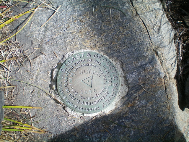
The USGS benchmark atop Ulysses Mountain. Livingston Douglas Photo
East Shoulder, Class 2+
The Descent
From the lookout tower, descend southeast then east down an open (initially) shoulder of brush, veg, and downed trees with loose underlying talus/scree in many spots. The shoulder is better defined than the USGS topo map suggests but it is a miserable bushwhack—the veg is thick and the deadfall is unending. Continue to bash your way through the awful brush, deadfall, and veg as the shoulder wiggles a bit as you descend.
The shoulder bends left-ish/northeast and approaches a large gully that cuts the east face of Ulysses Mountain. Reach old, overgrown FSR-443 near this gully and follow it northeast across the gully then southeast to reach its unsigned junction with FSR-005. Follow FSR-005 right/south for about ½ mile to the roadside pullout near the junction of FSR-005 and FSR-164. Given the difficult bushwhacking on this descent route, it is probably better to descend the shoulder that is between Point 7642 and the lookout tower. From my vantage point, it looks much more open and less brushy than the shoulder that I chose.
Additional Resources
Regions: Bitterroot Mountains->NORTHERN IDAHO
Mountain Range: Bitterroot Mountains
Longitude: -114.11039 Latitude: 45.42939