Elevation: 9,981 ft
Prominence: 671

This peak is not in the book. Updated November 2021
White Valley Mountain is located north of Spruce Gulch Lake and north-northeast of North Twin Peak (10,196 feet). The most straightforward ascent route is via FSR-092/White Valley Creek Road and an ATV trail that heads up to Spruce Gulch Lake. But FSR-092 is a rough road and may require an ATV or MC after reaching 6,800 feet and the 2-mile point. USGS Twin Peaks
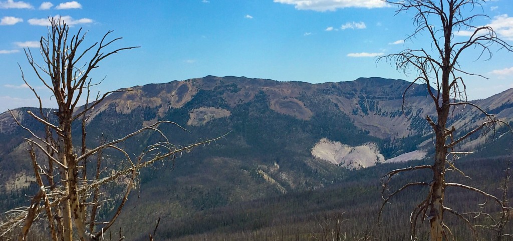
White Valley Mountain as viewed from the west.
Access for North Twin Peak Approach
From US-93 at the north end of Challis, turn left/west onto [signed] Clinic Avenue. Follow Clinic Avenue as it goes west briefly, then jogs north briefly, then heads west to a “T” junction with [unsigned] Challis Creek Road. This junction is 0.4 miles from US-93. Turn right/north onto Challis Creek Road and drive 9.7 miles to a signed junction. Go left for Mosquito Flat Reservoir (7 miles) and go straight/northwest for Bear Creek Road and Twin Peaks. Go straight here.
This road heads northwest briefly then turns sharply left/southwest to cross some private property and reach the Bear Creek drainage. The road bends right-ish/west to follow Bear Creek upstream. It is labeled as “Sleeping Deer Road.” From the signed junction on Challis Creek Road, drive 7.9 miles on Sleeping Deer Road/FSR-086 to a signed “T” junction just above the old Twin Peaks Guard Station. Turn right and drive another 0.4 miles to the ridge saddle between North Twin Peak and South Twin Peak. Park here (9,183 feet).
North Twin Peak Approach, Class 2
From the 9,183-foot saddle, bushwhack north up through open pine forest with a loose gravel/sand base with some scree mixed in. Higher up, the trees become scattered and the terrain is mostly loose gravel. Skirt the right/south side of Point 9650 to reach a minor saddle. From the saddle, scramble up another steeper, looser section of open pine forest to reach the open, rocky terrain above. Work your way up talus slopes and over/around ridge outcrops to approach the northwest summit. Scramble up a steep-ish talus slope to reach the northwest summit hump. Do not continue to the true summit.
Ridge Traverse from North Twin Peak to White Valley Mountain, Class 2
From the northwest summit of North Twin Peak, descend north then northeast to the 9,310-foot connecting saddle. Scramble northeast along the ridge to Point 9860. From Point 9860, follow the ridge north down to a minor saddle at 9,739 feet. Continue north up the ridge to the summit of White Valley Mountain. The ridge traverse from the connecting saddle to the summit has some ridge trees and rocky outcrops to skirt. In addition, there are several minor ups and downs in addition to the aforementioned drop to the saddle at 9,739 feet. On the return trip, you must re-climb both Point 9860 and North Twin Peak. This laborious, up-and-down adventure covers about 7 miles with 2,900-3,000 feet of elevation gain round trip.
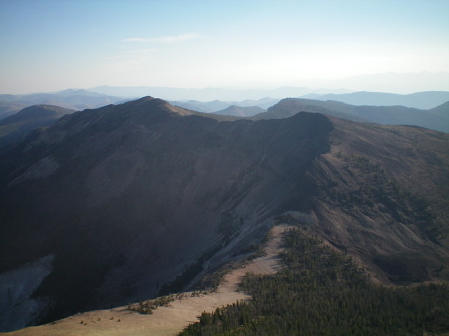
The ridge traverse to White Valley Mountain as viewed from the summit of North Twin Peak. The summit of White Valley Mountain is left of center with Point 9860 right of center. Livingston Douglas Photo
Access for White Valley Creek Approach
From US-93 at the north end of Challis, turn left/west onto [signed] Clinic Avenue. Follow Clinic Avenue as it goes west briefly, then jogs north briefly, then heads west to a “T” junction with [unsigned] Challis Creek Road. This junction is 0.4 miles from US-93. Turn right/north onto Challis Creek Road and drive 9.7 miles to a signed junction. Go left for Mosquito Flat Reservoir (7 miles) and go straight/northwest for Bear Creek Road and Twin Peaks. Go straight here onto [unsigned] FSR-086/Sleeping Deer Road. Drive about 0.7 miles up well-graded FSR-086 to an unsigned junction after a sharp bend in the road. You are now on the left/west side of the White Valley Creek drainage. Turn right/northwest onto [unsigned] FSR-092/White Valley Creek Road and drive two miles to the 6,800-foot level. The road becomes very rough after this point and an ATV or MC is advised. Lacking such, use your legs and walk the rough road.
White Valley Creek Approach and Climb, Class 2
From FSR-092 at the 6,800-foot level, hike (or ride) northwest up the road as it follows White Valley Creek. After about 1.5 miles, the road bends sharply left/south to leave the White Valley Creek drainage. From here, you have two choices. First, continue up the road to the 9,300-foot level where the road crosses a shoulder and drops to Spruce Gulch Lake. Leave the road here and scramble north then west to reach the south ridge. Please refer to the Baugher Trip Report for more details.
Second, leave the road at the sharp bend (at 7,720 feet) and bushwhack northwest then west up the White Valley Creek drainage to a high basin and a small pond at 8,724 feet. From the pond, choose a feasible line to either head north up onto the east ridge or head west directly onto the south ridge. The scramble west is probably the less steep climb to the ridge crest of the two options. And given the loose gravel terrain that dominates this area, “steeper is worser” as they say. Once on the ridge crest, follow the respective ridge to the summit.
If the bushwhack up the White Valley Creek drainage becomes too onerous, then exit the drainage onto the broad shoulder on its right/north side and follow the shoulder up toward Point 9737. Angle northwest to skirt Point 9737 and reach the east ridge at a saddle at 9,540 feet. Follow the easy ridge west to the summit of White Valley Mountain. If you begin your hike at the 6,800-foot level on FSR-092, you must cover about 11 miles with 3,200 feet of elevation gain roundtrip. There are minimal ups and downs with this route.
The Baugher route is a longer route and includes a ridge descent from Point 9860 to Saddle 9739 on the way to the summit. If you can ride an ATV or MC to the aforementioned 9,300-foot shoulder, the Baugher route is your best choice. I would not advise hiking from the 6,800-foot level on FSR-092 to the 9,300-foot saddle since you’re looking at a 15-mile adventure with 3,500 feet of elevation gain roundtrip.
Additional Resources
Mountain Range: Eastern Salmon River Mountains
Longitude: -114.44889 Latitude: 44.62139