Elevation: 6,793 ft
Prominence: 133
This peak is not in the book. Published November 2019
Wooden Shoe Butte is a small butte in the northern section of the South Hills. It is tucked behind Grand View Peak to the south and is blocked by a ridge above Steer Basin to the east. The easiest access is via a long ATV ride up FSR-617 from the south. The Steer Basin route is the shortest hiking route but it is challenging physically and navigationally. The brush and treed patches in this area are very thick and, in some cases, are impassable. USGS Grand View Peak
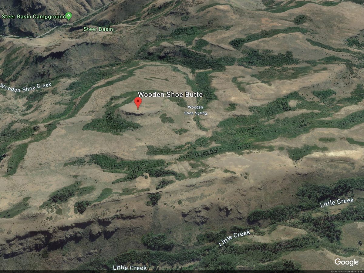
Google Earth Image
Steer Basin Route, Class 2+
Access
From the junction of US-30 and Rock Creek Road in Hansen, ID, drive south on Rock Creek Road for 18.8 miles (or 3.5 miles south of the Sawtooth National Forest boundary) to reach the entrance of the Steer Basin Campground. Park in a pullout at alongside Rock Creek Road at the entrance to the campground. The campground elevation is 4,965 feet.
The Climb
This is a much more challenging route than the simple scramble up the south face from FSR-617. Reaching FSR-617 will test both your bushwhacking and navigational skills. The parking pullout at the entrance to Steer Basin Campground offers an outstanding view of the first section of the route. You must cross Rock Creek and climb a steep face to reach a prominent shoulder on the west side of the campground. This shoulder has a massive rocky outcrop/prow at its north end that must be avoided. All of this is visible from the pullout.
From the parking pullout, walk down the entrance road to the campground and walk right/west through the small camping area to find a nice log hidden in the brush that surrounds Rock Creek. This is where the climb begins. Cross to the west side of Rock Creek on the log and climb diagonally southwest up a steep slope of field grass and gravel to reach the shoulder just left/south of the massive rocky cliffs on the shoulder. If you reach the rock face before reaching the ridge, simply follow the base of the cliffs southward to reach the ridge crest. A short scramble upward will get you there. From the campground, this scramble requires about 300 vertical feet of uphill.
Follow the crest of the shoulder southward up relatively steep, but easy, short grass/scrub. The open terrain gives way to much rougher, thicker brush higher up (with boulders mixed in for added punishment) and then a thick patch of unforgiving mountain mahogany. The going is slightly easier to the right/west of the ridge crest, but not by much. Use your judgment to minimize your agony. The section of mountain mahogany is rather flat and visibility is nil. You will be happy to reach a flat open point at 6,020 feet. Do not minimize the importance of this minor hump. It is your ticket home on the descent. If you fail to find it on the descent, you could easily be tangled up in impossible brush/scrub in Steer Basin or be cliffed out on the east face of this shoulder above Rock Creek. Navigational skills and a good memory are critical from here onward.
The shoulder doglegs west then southwest from here and the view is ugly. There are obvious cliff bands that block easy access to the high plateau above (and to the southwest), but that plateau provides the access necessary to reach Wooden Shoe Butte. Worse yet, there is impossibly thick brush/willows and boulders to make any access to the high plateau the crux of this climb. But there is a way to thread this needle and make it up onto the plateau.
From the minor hump at 6,020 feet, descend west to a minor saddle through an open field of sagebrush (weaving required). Continue west across more sagebrush, aiming to reach an obvious rocky shoulder that points northeast. This shoulder is your ticket to the high plateau. When you reach the rocky shoulder, stay near the ridge crest or just to its right/north. A short, steep, absolutely wickedly thick section of willows must be bashed through in order to reach rockier, easier terrain higher up the shoulder. After the willows, a cliff face must be climbed. Find a minor crack/chimney in this wall (to the R of the ridge crest) and climb up it to reach easier, more open terrain above. Follow a ledge left/south to reach the ridge crest.
Follow the ridge crest upward to reach a flat area that is clogged with mountain mahogany. Head southwest to reach open scrub and continue southwest to reach a forested hump that is Point 6679. Get a good visual of how the descent route will look from here because you must find the top of the northeast spur shoulder you just climbed in order to make your way back to the primary north shoulder you climbed up from the Steer Basin Campground. Navigational skills are critical here because sometimes visibility is nil due to the mountain mahogany, willows, and tall scrub both on the ascent and the descent of this route.
The journey to this point has only covered about 1-1/2 miles but has taken about 1-3/4 hours! Wooden Shoe Butte is still another 1-1/2 miles away, but the terrain is much flatter and faster to cover now. Wooden Shoe is obvious with its rocky cliff bands somewhat concerning. Your task now is to do a cross-country scramble across field grass and sagebrush with three or four minor gullies and shoulders to navigate. From Point 6679, maintain a westerly line and skirt north of an impossibly thick, short aspen forest to cross the first shoulder and stay just south of the head of a couple of brush/scrub-filled gullies along the way.
There is a final patch of impossibly thick pines/aspens to go through. Find a cattle trail and a narrow patch of open scrub to descend through this forested patch on its left/south side. It will be critical to find this open sliver on the return, so make a visual note of its location as you continue the cross-country scramble. Cross a final section of open scrub and then drop through a very short patch of not-so-awful aspens to reach Wooden Shoe Creek (a small stream) and the jeep road on its far side (FSR-617). You are now at the base of the south face of Wooden Shoe Butte.
There is an obvious, grassy chute that is the weakness is Wooden Shoe Butte’s imposing cliffs. The chute is on the left/west side of the South Face. Scramble up through the scrub to reach the chute and work your way up through field grass and talus to reach the tilted plateau that is the summit of Wooden Shoe. Head northeast to reach the east side of the summit plateau which, based on visuals and altimeter measurement, is the high point. Since the USGS map plots the high point at the western edge of the summit plateau, bushwhack through sagebrush and scattered boulders to reach that rocky point. It measures five feet lower than the east summit, according to my altimeter.
West Face, Class 2
The Descent
This route is part of a ridge traverse from Wooden Shoe Butte to Grand View Peak. From the west summit of Wooden Shoe Butte, descend the cliff band just below the summit plateau to reach the easier scrub terrain below. If the cliff band downclimb is too onerous for you, you can always return to the grassy gap in the south face to reach the west face from there. Angle southwest from the base of the cliffs to intercept FSR-617 at a point where it is in the open rather than where it is moving through thick forest. The terrain on the west face is open, somewhat tedious, sagebrush.
Additional Resources
Regions: South Hills->SOUTHERN IDAHO
Mountain Range: South Hills
First Ascent Information:
- Other First Ascent: Steer Basin Route, Class 2+
- Year: 2019
- Season: Summer
- Party: Livingston Douglas
Longitude: -114.28609 Latitude: 42.27209