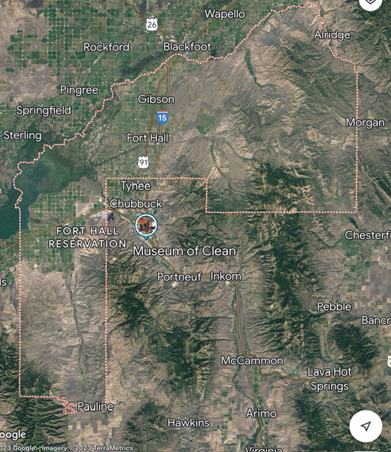
There are a group of sagebrush and forested hills along Arbon Valley Road south of I-86 that include peaks in the Bannock Range and Deep Creek Mountains. This article provides an overview of these peaks which are all located on the Fort Hall Indian Reservation and require a “trespass permit” to climb them. Currently, such a permit is not being given out to non-Tribal members but this status may change in the future. If you climb with a Tribal member, you may be able to obtain permission.
The Shoshone-Bannock Fort Hall Reservation
Access
From Exit 52/Arbon Valley on I-86, drive south on [paved] Arbon Valley Road. Arbon Valley Road is a 60MPH highway in its northern section. It stretches for many miles and bifurcates the Deep Creek Range (to the west) from the Bannock Range (to the east). It has extensive private property holdings all along it, initially as Fort Hall Indian Reservation land then as private landowners south of the Tribal land. The focus of this expose is on the Tribal land.
Unlike the Tribal land along I-86 and I-15 in eastern Idaho, the Tribal land along Arbon Valley Road does not have signs at its borders with non-Tribal land. There are large signs along I-86 and I-15 when you enter the extensive area of the Fort Hall Indian Reservation. While there are no road signs to indicate the boundaries on Arbon Valley Road, every side road (all of which are poor in quality and probably are not drivable) along Arbon Valley Road IS clearly posted with a small “Fort Hall Indian Reservation: No Trespassing” sign.
But there is very little fencing along the Tribal land, no orange paint, no signage (except for the side roads), and the terrain is almost entirely non-irrigated sagebrush. And that can be confusing. You are responsible to know the boundaries of Tribal land versus non-Tribal land, so do your homework. Don’t screw this up.
October 2023 Access Status
I spoke with the Land Use Department (208-478-3825) of the Shoshone-Bannock Indian Tribes. The Land Use Commission is not currently issuing “Trespass Permits” (as they call them) to non-Tribal members and has not done so for many years. This may change in 2025 if some of the Commission members are replaced with members who are more accommodative to non-Tribal members. You may be able to get a trespass permit if you team up with a Tribal member to do a climb.
Tribal Land versus Non-Tribal Land
There are three types of Tribal land. First, there is Trust Land. Trust Land (Common Land) is available to all Tribal members. This is the only land that a “Trespass Permit” applies to. The bulk of the Fort Hall Indian Reservation is Trust Land. Second, there is Allotted Land. This is private property that is owned by a Tribal member within the boundaries of the overall Reservation. Third, there is Fee Land. This is private property that is owned by a non-Tribal member within the boundaries of the overall Reservation. Fee Land is akin to private property owners within the boundaries of BLM or National Forest land. That’s always confusing, isn’t it?
Trespassing Laws on Tribal Land
Each tribe determines its own rules and regulations with respect to trespassing. It is not regulated in United States or State of Idaho courts. Consider yourself in a foreign country with completely separate laws and regulations. Consequently, it is never a good idea to trespass on Tribal land. You can have your pack confiscated and face sentencing in Tribal Court. The Tribal Court for the Fort Hall Indian Reservation is in Fort Hall, Idaho, just north of Pocatello. As a non-Tribal member, you do not want to end up there.
The trespassing laws in the Nez Perce Indian Reservation of western Idaho may differ from those in the Fort Hall Indian Reservation. The trespassing laws in the Coeur d’Alene Indian Reservation in northern Idaho may differ from both of the aforementioned reservations elsewhere in Idaho. So do your homework and get the appropriate permit(s) before even planning to climb mountains in those reservations. If you are going to cross private property within Tribal land, you must obtain written permission from the landowner before entering, just as you do for non-Tribal land. So you may need two types of permissions: one from a private landowner (for the private land segment) and one from the Tribe (for the trust/common land segment) for a given climb.
Other Issues
There are some areas of mountains that are strictly off-limits in certain Tribal land area. For example, the summit area of Mount Baldy (11,403 feet) in northeastern Arizona is off-limits at all times. It is considered to be sacred by the White Mountain Apache Indian Tribe. So even with a permit to climb high up on Mount Baldy, you are not allowed to stand on the summit. It is not uncommon for Tribes to prohibit standing atop mountains that are on reservation land. Summits are considered a holy/sacred place.
The Northern Arbon Valley Peaks
There are nine (9) peaks in the Northern Arbon Valley that are worthy of consideration if, and only if, you are able to obtain the appropriate permission(s) to climb there. They are all within the confines of the Fort Hall Indian Reservation. All of them are reasonably reachable from Arbon Valley Road and do not require a fording of the Bannock River. All of these peaks lie between Pauline and I-86. It is a 23.5-mile drive from I-86 to the signed junction with South Mink Creek Road at the south end of Pauline. The routes suggested below are based solely on observation and mapping data. Here are the peaks listed from north to south:
Flatiron Hill (5,738 feet)
Mountain Range: Bannock Range
Map: USGS Flatiron Hill
Prominence: 358
LOJ Link: https://www.listsofjohn.com/peak/38715
Route: East Face from Rattlesnake Creek Road to its south (Class 2); Climb it in combination with Peak 5660.
Peak 5660
Mountain Range: Bannock Range
Map: USGS Flatiron Hill
Prominence: 280
LOJ Link: https://www.listsofjohn.com/peak/38809
Route: South Ridge from Rattlesnake Creek Road to its south (Class 2)
Peak 5288
Mountain Range: Deep Creek Range
Map: USGS Sawmill Creek
Prominence: 308
LOJ Link: https://www.listsofjohn.com/peak/39194
Route: Southeast Face from Starlight Creek Road (Class 2)
Peak 5535
Mountain Range: Deep Creek Range
Map: USGS Flatiron Hill
Prominence: 555
LOJ Link: https://www.listsofjohn.com/peak/38950
Route: Northwest Face from Starlight Creek Road (Class 2)
Peak 6192
Mountain Range: Bannock Range
Map: USGS Flatiron Hill
Prominence: 892
LOJ Link: https://www.listsofjohn.com/peak/38134
Route: West Face (Class 2)
Peak 5982
Mountain Range: Bannock Range
Map: USGS Flatiron Hill
Prominence: 282
LOJ Link: https://www.listsofjohn.com/peak/38416
Route: South Ridge from a Side Jeep Road (Class 2)
Peak 5868
Mountain Range: Bannock Range
Map: USGS Pauline
Prominence: 288
LOJ Link: https://www.listsofjohn.com/peak/38562
Route: Northwest Face from a Side Jeep Road (Class 2); Climbed in combination with Peak 5982.
Peak 5921
Mountain Range: Bannock Range
Map: USGS Pauline
Prominence: 381
LOJ Link: https://www.listsofjohn.com/peak/38493
Route: East Ridge from a Side Jeep Road (Class 2); Climbed in combination with Peak 5982.
Peak 5773
Mountain Range: Bannock Range
Map: USGS Pauline
Prominence: 393
LOJ Link: https://www.listsofjohn.com/peak/38663
Route: West Face (Class 2)
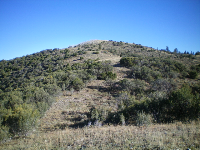
This photo is representative of the type of terrain found in the Deep Creek Mountains peaks found in the reservation. Livingston Douglas Photo
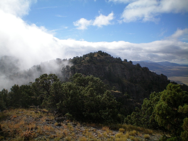
This photo is representative of the type of terrain found in the Bannock Range peaks found in the reservation. Livingston Douglas Photo