Mountain Range: Pioneer Mountains
Maps: USGS Smiley Mountain, USGS Trail Creek
Peaks: Peak 10500, Pion Peak (10,700 feet), Err Peak (10,744 feet), and Argosy Peak (10,377 feet)
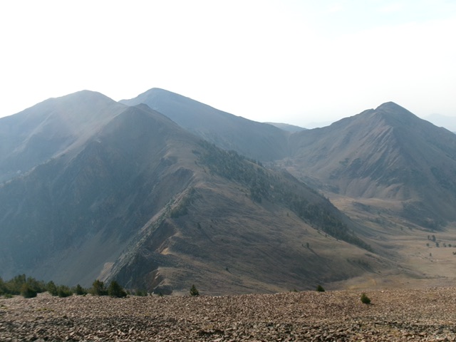
The triad of Pion Peak (hump at far left), Err Peak (just right of Pion Peak in the distance), and Argosy Peak (well right of center) as viewed from Peak 10500 to the northwest on a smoke-hazy morning. Livingston Douglas Photo
Access
Muldoon Creek Road/FSR-126 [(E)(1.1) on Page 261]. From Copper Creek Road, drive east then northeast up [unsigned] Muldoon Creek Road/FSR-126 for 2.4 miles to a minor pullout at the base of the east face of Muldoon Ridge. Park here [6,925 feet; 43°35’31.3”N, 113°53’11.3”W]. This is the same launch point as Tom Lopez used for his climb of Pion Peak/Err Peak/Argosy Peak.
Do not attempt to begin this adventure from the mouth of the Argosy Creek drainage. There is posted, gated private property there along Muldoon Creek Road. The Argosy Adventure covers 10.5 miles with 5,300 feet of elevation gain round trip.
Approach Climb Up Argosy Creek, Class 2
The Climb
From the improvised pullout on Muldoon Creek Road, drop 25 vertical feet in easy, open field grass and pine forest to cross Muldoon Creek. Use cattle trails to reach and exit the creek drainage. Contrary to Tom Lopez, I found no difficulty getting through a few willows to the creek directly below the pullout spot. However, crossing the creek was more challenging. A short distance downstream, I found a few tree branches across the creek and crossed it there. I used a hiking pole to keep from falling into the creek here, so be advised.
Once across the creek, follow a good cattle trail up out of the drainage. Contour southeast then east on a cattle trail to reach the north side of the Argosy Creek drainage. Immediately find a cattle trail (there is no longer an old road here as shown on the USGS topo map) that heads up the left/northwest then west side of Argosy Creek. There are some remnants of the old road bed occasionally here but not for long. The cattle trail becomes a game trail as you advance farther up Argosy Creek. It crosses [small] Argosy Creek a few times on the way.
Higher up, the pine forest ends and the terrain is open, thick-ish scrub. Argosy Creek becomes a very small stream. The game trail narrows but is still there. The terrain becomes ribs of scrub next to the stream. As you gain more elevation, the terrain becomes easy, short scrub and a series of shoulders in the wide drainage. You pass by the wickedly rocky and steep west face of Argosy Peak on the way. Get a good look at a nice, wide gully that heads right/east up to the south ridge of Argosy Peak as you work your way up through the Argosy Creek drainage. I descended it after completing the four peaks of today’s adventure.
Once past Argosy Peak, the drainage really widens quite a bit. The terrain is short scrub that morphs into a rockier mix as you approach the head of the massive drainage. You could climb Peak 10500 via the southeast side of its southwest ridge but the slope is steep and very loose. The better option is to continue up the drainage to its terminus at the 9,900-foot connecting saddle between Peak 10500 and nearby Pion Peak (10,700 feet). The final, steep-ish push up to this small saddle is on a mix of tundra, short scrub, and easy talus/scree. Avoid the larger patches of talus and scree that are nearby.
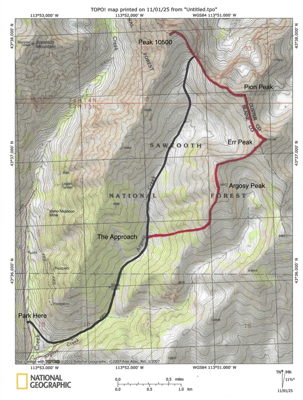
Route Map for The Argosy Adventure. The approach (black line) and the ridge traverse (red line).
Peak 10500 (Fishpole Peak)
Southeast Ridge, Class 2
The Climb
From the 9,900-foot connecting saddle between Pion Peak and Peak 10500, scramble north then northwest in relatively stable scree/gravel with pines early on. The rocky summit of Peak 10500 has three large cairns and a stunning view down to Fishpole Lake. Return to the 9,900-foot connecting saddle to begin the climb of Pion Peak.
Pion Peak (10,700 feet)
Northwest Ridge, Class 2
The Climb
From the 9,900-foot connecting saddle with Peak 10500, scramble up short scrub and scree/gravel with some goat trails to help. Climb up over a gentle ridge hump and head left-ish/east to reach the summit hump of Pion Peak. The summit has a large cairn.
South Ridge, Class 2
The Descent
From the summit, descend south on a ridge crest of easy scree and gravel to quickly reach the 10,300-foot connecting saddle with Err Peak.
Err Peak (10,744 feet)
North Ridge, Class 2
The Ascent
From the 10,300-foot connecting saddle, scramble south then southeast in easy, open scree/gravel to the cairned summit of Err Peak.
Southwest Ridge, Class 2
The Descent
From the summit, descend southwest on magnificent scree/gravel to reach the 10,020-foot connecting saddle with Argosy Peak.
Argosy Peak (10,377 feet)
Northeast Ridge, Class 2
The Climb
From the 10,020-foot connecting saddle, climb west then southwest then south up the bending ridge crest. The ridge terrain is a somewhat-tedious mix of ridge rock, rocky outcrops, and stable scree/gravel. Descend 40 vertical feet from the false north summit to reach a minor saddle. Scramble south up to the cairned high point of Argosy Peak.
South Ridge/West Gully, Class 2
The Descent
From the summit, descend the ridge crest south then southwest then south on miserably-loose talus and boulders to reach the head of a forested gully that sits just north of the 8,740-foot saddle that is located just underneath, and north of, Point 8978.
Leave the ridge and descend an open, rocky gully that heads southwest then west down to the Argosy Creek drainage. The gully widens as you descend. It is easiest to stay on the left/south side of the gully initially in easy pine forest with a gravel base. Lower down, move into the scree-filled gully as it opens up and widens out. The scree is still unstable so be careful. Reach the easy terrain of the wide Argosy Creek drainage and follow game and cattle trails back to the crossing of Muldoon Creek. Ford the creek and hike a short distance back up to Muldoon Creek Road and your parked vehicle.