Elevation: 7,338 ft
Prominence: 411
This peak is not in the book. Published November 2020
Thurmon Ridge is a narrow, thickly-forested ridge located just above, and to the northeast of, Green Canyon Pass (6,927 feet). It requires a somewhat tedious bushwhack in thick, veg-ridden forest from the pass. It is a ranked summit and is a worthy objective. This climb is part of a 3-peak adventure that includes Thurmon Ridge (7,338 feet), Moonshine Mountain (6,931 feet), and Bishop Mountain (7,810 feet). USGS Bishop Mountain
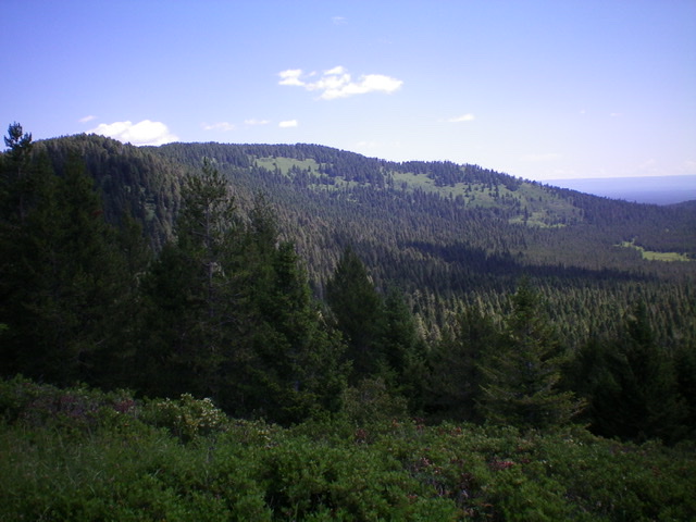
Thurmon Ridge (partially forested, in center at a distance) as viewed from the southwest. Livingston Douglas Photo
Access
Green Canyon Pass is located 5.8 miles up Green Canyon Road/FSR-167 from US-20 south of Island Park, ID. The turnoff is on the west side of the highway and is signed for Harriman State Park. It has a small street sign for “Green Canyon Road.” Green Canyon Pass is not signed but is the high point on Green Canyon Road and has a nice dispersed campsite on its west side.
Map Errors
The Caribou-Targhee National Forest Map (2010 edition) shows FSR-861 coming up from Green Canyon Road to the Thurmon Ridge/Moonshine Mountain saddle, but no such road exists. Not even remnants of it. The USGS topo map shows roads and trails in the basin that separates Thurmon Ridge from Moonshine Mountain. No such roads or trails exist. None.
Southwest Ridge, Class 2
The Climb
From Green Canyon Pass (6,927 feet), bushwhack east through thick pine forest and lots of thick veg to reach the southwest ridge. Follow the ridge northeast. The bushwhack gets easier higher up and you will find a decent game trail (for a while) through the shorter veg and around the blowdown in the forest. You must cross over a forested hump at 7,210 feet and drop 30 vertical feet to a narrow saddle to continue up the ridge. Continue to the flat ridge crest summit area. The high point seems to be a large pine tree in the thick forest, but there are no markers or cairns. I found no points that are higher and continued east to begin the descent of the east ridge/south face to the connecting saddle with Moonshine Mountain.
East Ridge/South Face, Class 2
The Descent
From the summit, bushwhack east through the dense forest and veg, dropping about 20 vertical feet initially and recovering 10 feet of the drop farther along the ridge crest. Upon reaching the east end of the flat summit area, descend east through the forest to a saddle just west of Point 7156. Climb up over Point 7156 (which is semi-open) and bushwhack southeast then south down a steep face of thick pine forest, blowdown, and veg to reach the semi-open connecting saddle with Moonshine Mountain.
There is an open, grassy meadow nearby. There is also an old 2-track jeep road (not shown on any maps) running north-south along this saddle. Where it goes, who knows? This is the conclusion of the first leg of a 3-peak journey. Moonshine Mountain is up next.
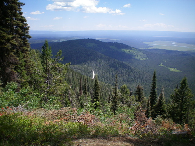
Thurmon Ridge (in shade in mid-ground) as viewed from the summit of Bishop Mountain. Livingston Douglas Photo
Additional Resources
Regions: Centennial Range->EASTERN IDAHO
Mountain Range: Centennial Range
Longitude: -111.52329 Latitude: 44.35001