Elevation: 7,073 ft
Prominence: 243
This peak is not in the book. Published January 2023
Crater Mountain is the northernmost point on Pelican Ridge. It is located on the northeast side of Blackfoot Reservoir and is just south of Wilson Pass on State of Idaho land. This is the second leg of a 2-peak journey that includes Limerock Mountain (7,488 feet) and Crater Mountain. This adventure covers 7.0 miles with 1,750 feet of elevation gain round trip. USGS Henry
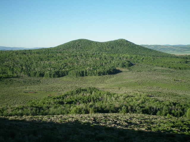
The twin forested humps atop Crater Mountain as viewed from the north. The right/west hump is the high point. Livingston Douglas Photo
Access
Same as for Limerock Mountain. This is the second leg of a 2-peak adventure.
Northwest Face, Class 2
The Climb
From the unsigned road junction, hike south up a 2-track ATV trail to reach the base of the northwest face of Crater Mountain at a shoulder crossing. Take a good look at the northwest face to identify a line that is the least punishing. The northwest face is an ugly mess of thick aspens (low) and steep, thick brush (high). Leave the road here and bushwhack southeast across somewhat thick sagebrush and other brush to reach the aspen forest at its narrowest point. Bash southeast through very thick aspens, blowdown, and brush to reach steeper terrain and slightly less-thick aspens higher up. This is a short but very PUNISHING bushwhack, particularly in the initial, flattish section of the aspen forest. Emerge from the aspen forest in steep, open scrub with underlying talus/boulders (high up) to reach the summit ridge and, soon after, the cairned summit of Crater Mountain.
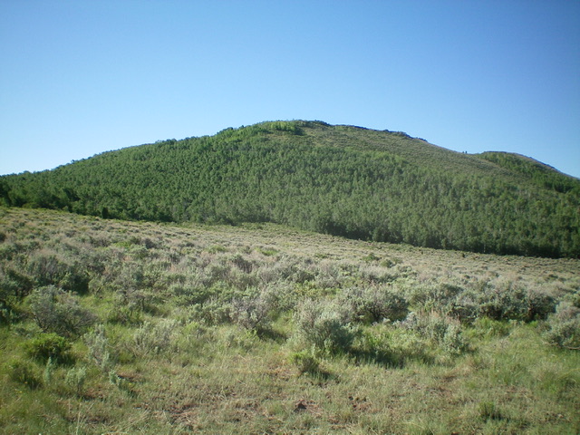
The northwest face of Crater Mountain. The aspen forest is a wicked bushwhack. Livingston Douglas Photo
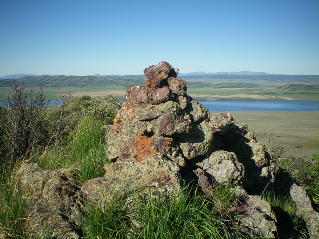
The large summit cairn atop Crater Mountain with Blackfoot Reservoir in the distance. Livingston Douglas Photo
West Face, Class 2
The Descent
From the summit, descend the west face, aiming for a narrow patch of aspens lower down. Up high, the terrain is loose rock and brush (plus some scattered aspens). The aspen forest is wickedly thick with lots of blowdown. Emerge into open sagebrush and head north to intercept the ATV trail. Follow the ATV trail to its junction in the meadow below Limerock Mountain. Go left/west onto Wilson Pass Road and return to your parked vehicle.
Additional Resources
Regions: Blackfoot Mountains->SOUTHERN IDAHO
Mountain Range: Blackfoot Mountains
Longitude: -111.61749 Latitude: 42.98469