Elevation: 9,484 ft
Prominence: 1,224
This peak is not in the book. The route information below was provided by Matt Durrant and Livingston Douglas. Updated November 2018
2014 Update by Matt Durrant
The Franklin County High Point is an unnamed peak on the Franklin/Bear Lake County line at 9,484 feet. Most people believe Wilderness Peak to be the highest point in Franklin County, but that is not true. Wilderness Peak, although more well-known and more dramatic, sits at 9,460 feet, just 24 feet shorter than the actual high point (9,484 feet). This mountain sits at the north end of Egan Basin, just to the east of Danish Pass. It is seldom climbed because it is quite an obscure mountain. The only folks who ever reach the top (or even try for that matter) are County High Pointers.
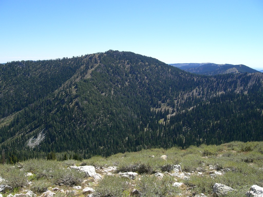
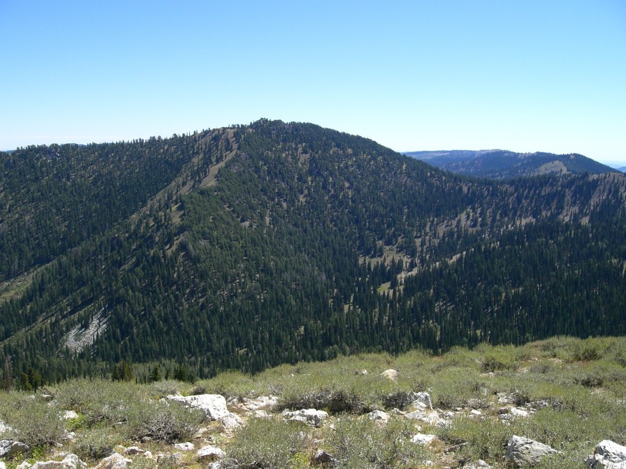
Peak 9484 as viewed from Cub Peak. Matt Durrant Photo
The Highline Trail also runs from Egan Basin to the ridge just west of the peak and is a very good trail. The actual high point consists of two very small and sharp pinnacles of rock on top of a great rounded, but rocky, summit. The tallest one appears to be the one on the north, but they are very close in height. They both protrude from the surrounding rock maybe only 3-4 feet. There is a summit register with a few names and instructions hidden under a pile of rocks just at the foot of the highest rock.
The view from the top is quite spectacular. To the south, almost the entire main crest of the Bear River Range is visible, from Mount Magog in Utah to Wilderness Peak in Idaho. Doubletop, also in Utah, appears to be the most prominent peak when viewed from this angle. To the north, all of the major Bear River Peaks in Idaho are visible, from Cub Peak and Saint Charles Mountain to Sherman Peak.
The summit is just the high point of a forested and rocky ridge. It sits on the northern end of the ridge overlooking Snowslide Canyon and Saint Charles Canyon. Just to the west and immediately below the summit is a bowl shaped feature with grass, rocks, and ancient tress, where deer and other animals live. It is a beautiful and quiet place. You are almost guaranteed that you will see no one else here.
The mountain can be approached from many directions, but the most common is from the southwest, leaving the Egan Basin Road near Danish Pass. There is another possible approach via Snowslide Canyon to the northwest, but it would be a much longer hike as there is no road. The hike from Egan Basin gains about 1,100 vertical feet and is quite short.
From Preston, ID: Go south on US-91 and turn east onto Cub River Road. Follow the road for about 16 miles to the Willow Flat Campground. Once you get to the campground, keep following the road to the south and across the bridge. The road will the start to climb into Hillyards Canyon. The canyon is about 6 miles long and ends in Franklin Basin. Continue on the Franklin Basin Road for about one or two miles until you come to the sign directing you to Egan Basin to the east. Take this road, which winds through Danish Pass. From the pass, descend and park just before the road turns to the south. Peak 9484 is just to the northwest and is a rounded, tree-covered summit.
2018 Update by Livingston Douglas
North Ridge, Class 3
Access
Drive up Saint Charles Canyon Road/FSR-412 from just north of Saint Charles, ID on Highway 89. At the 8.0-mile point (just past the turnoff for Cloverleaf Campground and just before the turnoff for North Fork Campground), you will find a large parking area on the RHS of the road. If you reach the turnoff for the North Fork Campground, you’ve gone about 100 yards too far. Turn around at the campground entrance and park along FSR-412. You can drive into North Fork Campground to reach the trailhead parking area but you must pay a $7 day use fee. The elevation at the parking area along FSR-412 is 6,925 feet.
The Climb
From the North Fork Saint Charles Creek trailhead, hike (or ride a MC) 1.9 miles up FST-318 to a signed junction with the Snowslide Trail/FST-319 to your left. Thankfully, FST-318 has two excellent footbridges across the raging NF Saint Charles Creek and a third footbridge across the more modestly-flowing Snowslide Canyon Creek. The elevation at the junction of FST-318/FST-319 is approximately 7,450 feet. Follow FST-319 for about two miles, as it climbs west then southwest then south up Snowslide Canyon to cross to the east/left side of Snowslide Canyon Creek (a small stream) at 8,225 feet. You will find tree branches in the stream bed to make the crossing of the creek drainage easier for MC riders. Leave the trail here to climb east up onto the north ridge of Felt Hat.
The bushwhack east up onto the north ridge of Felt Hat is quite steep, especially higher up. Thankfully, the forest is open and easy, with a base of gravel, pine needles, and some short veg. The topography is a mix of numerous small gullies and small shoulders. The angle is so steep that I found the small gullies to work best. It’s pure pine forest; no rock to contend with. This is Class 3 terrain, as you will find yourself grabbing onto tree branches and, sometimes, climbing on all fours to advance upward. Once you reach the ridge crest, turn right/south and follow the north ridge up to the final summit ridge at a point just north of the summit rocks.
The terrain on the north ridge is a mix of open, steeply-angled desert scrub (left/east side of the ridge crest), steeply-angled pine forest and blowdown (right/west side of the ridge crest), and a line of pine trees and rocky outcrops on the ridge crest proper. The rocky outcrops were easiest to skirt on the right/west side, but you will probably spend most of your climbing on the leeward east side of the ridge crest. In any case, you will never wander too far from the ridge crest itself. The north ridge merges with the northeast ridge at about 9,350 feet in a flattish area. The final push southward to the summit rocks is a chore, thanks to a combination of rock, trees, and veg on the ridge crest itself without a better way around it.
The first high point you reach is the true summit. The gentle, rounded false summit to the west is about 150 feet away and is 10 feet lower than the rocky, true summit. Both summits are quite open, with a patch of desert scrub separating them. The true summit is comprised of two rock fins located about five feet apart. An airy summit for sure. As the Franklin County high point, this is a popular summit with a white post stuck in a nearby boulder and several summit registers tucked in some rocks at the base of the summit “fins”.
Northeast Ridge, Class 3
Access
This route is part of a loop route which begins at the trailhead for the North Fork Saint Charles Creek Trail/FST-318. Please refer to the Access Section for the north ridge for more information.
The Descent
From the summit, you have an outstanding view of the northeast ridge. You can’t see the north ridge from the summit because it is hidden by ridgeline trees and the nearby forest. From a distance, the northeast ridge looks like it is going to be a cruise to descend. But, alas, looks are deceiving. The northeast ridge is a tedious undertaking, even the seemingly-easy upper section that you can see from the summit.
On the USGS topo map, the northeast ridge looks magnificent. In reality, it’s heavily forested and clogged with trees, blowdown, veg, and rocky outcrops. In addition, a lengthy bushwhack awaits you when the northeast ridge ends just above the Snowslide Canyon drainage. All of that said, this ridge descent is quite doable with some sections of steep, Class 3 terrain. Yes, you will be using your hands as well as your feet on this descent route.
From the summit of Felt Hat, descend due north briefly along the tedious, clogged ridge crest in relatively flat terrain. At 9,350 feet, the ridge bends rightward/northeast and narrows considerably. Although the right/east side of the ridge is open terrain (desert scrub + gravel), the side-hilling is tedious and very steep. You simply have to stay close to the ridge crest and weave back and forth between the thick forest on the left/west side and the steep scrub on the right/east side. The ridge crest itself is impossible to descend since it is a mix of ridge pines and rocky outcrops.
Lower down, the northeast ridge becomes more rounded and eventually becomes a face. Consequently, it can be difficult to follow. Just stay on a northeasterly trajectory and you should be just fine. The slope doesn’t moderate until you’re almost in the Snowslide Canyon Creek drainage. Surprisingly, the veg in the drainage was relatively easy, with some open areas to cross as well. Continue northeast to reach the south side of the creek and pick up game trails here. These trails will help you reach the third and final footbridge on the NF Saint Charles Creek Trail/FST-318. Stay on the south side of the creek until you reach that footbridge. The trail will be waiting for you there. Follow the trail southeast back down to the trailhead and the North Fork Campground. Continue another 0.2 miles to reach the free parking area along Saint Charles Canyon Road/FSR-412.
Additional Resources
Regions: Bear River Range->SOUTHERN IDAHO
Mountain Range: Bear River Range
First Ascent Information:
- Other First Ascent: North Ridge
- Year: 2018
- Season: Summer
- Party: Livingston Douglas
- Other First Ascent: Northeast Ridge —Descent
- Year: 2018
- Season: Summer
- Party: Livingston Douglas
Longitude: -111.58076 Latitude: 42.09477
Pingback: Idaho County High Points by Andy Martin - IDAHO: A Climbing Guide