Elevation: 10,564 ft
Prominence: 384
This peak is not in the book. Livingston Douglas revised the introductory paragraph, the North Ridge Route, added a new descent route, and included new photos. Updated December 2024
Murdock Peak is located on the west flank of West Fork Trail Creek between Hemingway Peak and Mallory Peak. It sits above the headwaters of Murdock Creek, hence its unofficial name. Murdock Peak is most easily climbed via its east face and north ridge from the West Fork Trail Creek drainage. USGS Rock Roll Canyon
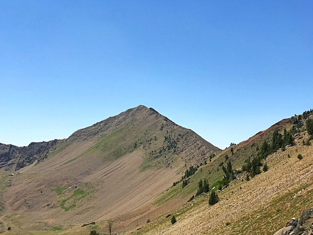
Murdock Peak as viewed from the ponds located northeast of the summit.
Access
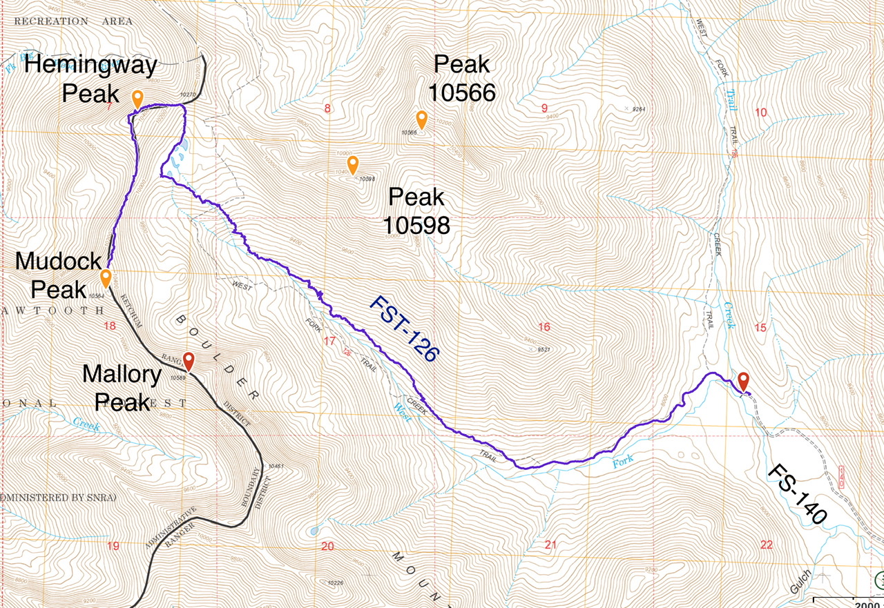
Park Creek Road, FS-140 and the Trail Creek Loop Trail, FST-126 [(B)(1)(a) Page 242]. The Trail Creek Loop Trail, FST-126 has not been maintained in many years. Furthermore, trail is not in the location shown on the FS topographic map. See the map below. The tread is easy to follow until roughly 9,000 feet. After that point, there are cairns marking the route until tree line. Expert route finding skills are recommended.
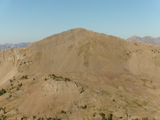
Murdock Peak and its steep east face. The north ridge is the skyline right of center and the southeast ridge is the skyline left of center. Livingston Douglas Photo
North Ridge, Class 2
From the upper reaches of the West Fork Trail Creek, climb to the saddle between Murdock and Hemingway Peaks. A steep goat trail switchbacks up to the ridge top. Once on the ridge you can follow goat trails on the west side of the ridge most of the way to the summit or stay directly on the ridge crest. The south ridge of Hemingway Peak can also be easily climbed from the saddle.
From the 10,100-foot connecting saddle with Hemingway Peak, scramble south up the open, narrow ridge crest, sometimes with the help of a goat trail, to reach the small ridgeline summit of Murdock Peak. The rocky, curving ridge crest is not overly steep and presents no difficulties. The summit has a modest cairn.
My GPS track to Hemingway and Murdock Peaks. It 9s 4.9 miles with 2,500 feet of elevation gain to the top of Hemingway Peak. It is another 0.5 miles with an additional 350 feet of elevation gain to the summit of Murdock Peak.
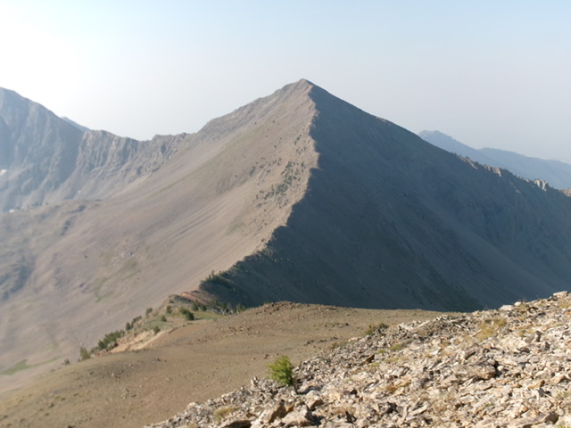
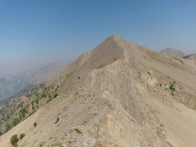
Murdock Peak and its curving north ridge. This was my ascent route. Livingston Douglas Photo
Southeast Ridge, Class 2+
The Descent
From the summit, descend the narrow, rocky ridge southeast as it weaves a bit and reaches a small ridge saddle at 10,180 feet. The open ridge crest has more solid embedded rock than the north ridge and is a bit more difficult than the north ridge. The small, narrow saddle is the connects to Mallory Peak (10,589 feet). It concludes the second leg of today’s 3-peak adventure. Mallory Peak is up next.
Murdock Peak and its southeast ridge. This was my descent route. Livingston Douglas Photo
Additional Resources
Regions: Boulder Mountains->EASTERN IDAHO
Mountain Range: Boulder Mountains
Year Climbed: 2020
Longitude: -114.35749 Latitude: 43.85219