Elevation: 5,235 ft
Prominence: 575
This peak is not in the book. Additional Danskin Mountains access information is in the book [(D)(1) on Pages 154-155 and (G)(1) on Page 156]. Also see the following website page: Danskin Mountains OHV Trails. Livingston Douglas provided the 2025 update found directly below. Pohlmann‘s entry is further down the page. Updated October 2025
Bridge Peak sits above the Danskin Bridge and the South Fork Boise River. It separates Mennecke Creek from Cayuse Creek. Bridge Peak is most easily climbed from the north on a BLM road that comes up from the Danskin Bridge. This area is a mix of private and public land, so be careful. This climb is entirely on BLM and National Forest land.
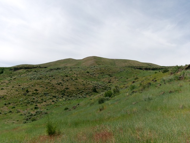
Bridge Peak as viewed from FSR-165C early in the climb. Livingston Douglas Photo
Access
From the signed junction of Prairie Road and Fall Creek Road, drive north then northwest on Prairie Road for 3.0 miles to a signed junction with a spur road (signed as “NE Joy Lane”) that goes left/northwest to cross the South Fork Boise River on Danskin Bridge. Drive 0.3 miles on this spur road and cross the bridge. After crossing the bridge, turn left onto a 2-track BLM road that follows the south side of the river. This road is signed as FSR-165C. Drive 0.1 mile southeast up this rugged 2-track and park in a nice parking area. The road gets much rockier and rougher after this point. The parking area is at 3,672 feet and 43°24’11.3”N, 115°33’48.4”W. This climb covers 4.0 miles with 1,625 feet of elevation gain round trip.
Northeast Spur/North Ridge, Class 2
The Climb
From the parking area, hike southeast on the rocky Forest Service road as it initially drops to the South Fork Boise River then climbs south up to a minor shoulder crossing. The road now drops and does a long switchback. Leave the road here and bushwhack southwest up through easy field grass to intercept the Forest Service road just below the road closure gate. Hike briefly on the road and pass the gate. Leave the road as it begins another long switchback.
Bushwhack southwest up a steep-ish, grassy gully (with good cattle trails to help) and intercept the road at a stinky cattle pond just to the left/southeast. Stay right/west of private ranch land (with a yurt and an outhouse) and scramble southwest up a steep face of many criss-crossing cattle trails to reach the northeast spur ridge. Follow this ridge in easy field grass up to a flat ridge point at a ridge juncture with the north ridge. Go left/south here and scramble up more moderately-angled field grass to the summit.
The summit of Bridge Peak has two potential high points, about 100 feet apart. They are very close in height, according to my altimeter. The first high point is the official high point. Both of these high points are rocky. I built a cairn on the official/east high point. Bridge Peak offers a magnificent view of rugged Peak 6591 to its northeast.
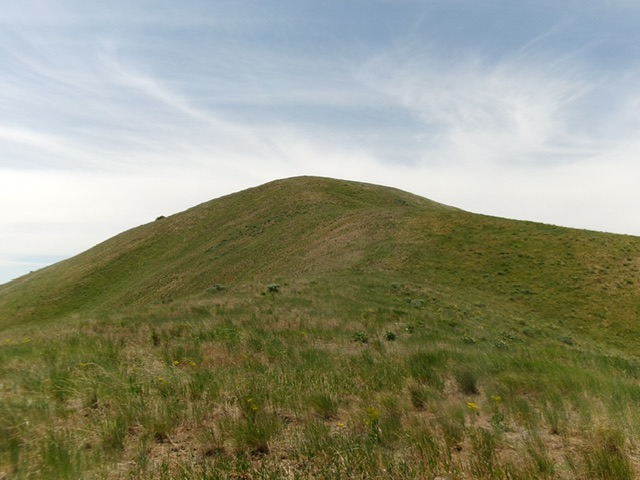
The summit hump of Bridge Peak as viewed from high on the north ridge. This was my ascent route. Livingston Douglas Photo
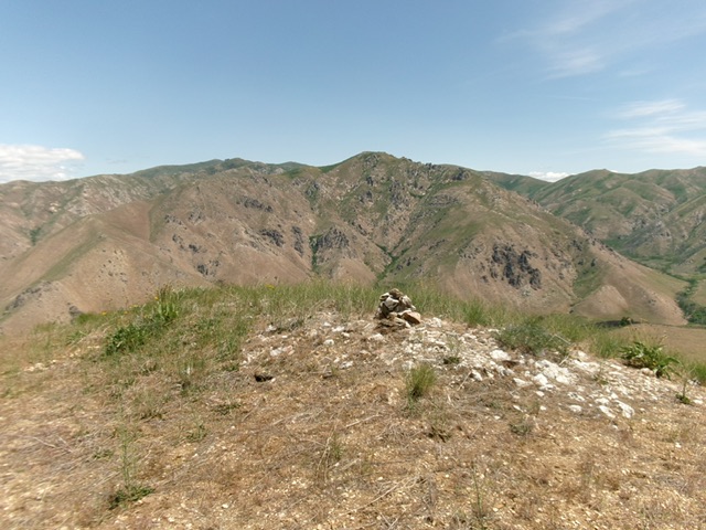
The summit of Bridge Peak with its newly-built summit cairn. Rugged Peak 6591 is in the distance. Livingston Douglas Photo
Bridge Peak by Erik Pohlmann
This peak is located is located east of the main Danskin Mountains Crest in a broad peninsula formed by a large bend in the South Fork Boise River. The peak is tantalizingly close to the South Fork Boise River Road [(E)(2.1) on Page 155] but, unfortunately, private property blocks an approach from that road. USGS Cathedral Rocks

Bridge Peak
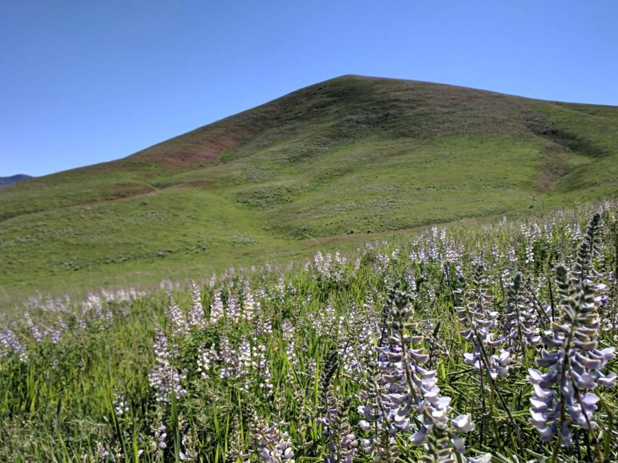
Although not particularly high, Bridge Peak is one of my favorite peaks in the range for many reasons: the view, route, remoteness, aesthetics, and simply the overall experience. Similar to Peak 4524/Buffalo Peak, Bridge Peak is curiously situated adjacent to one of the many flats which characterize namely the southern Danskins and offers fantastic views of Boise River Canyon. Unlike majority of peaks which are classically picturesque from one side (but somewhat disappointing and resemble more of a ridge from other angles), Bridge Peak is symmetric and maintains that classic peak aesthetic from all angles which further enhances the summit experience.
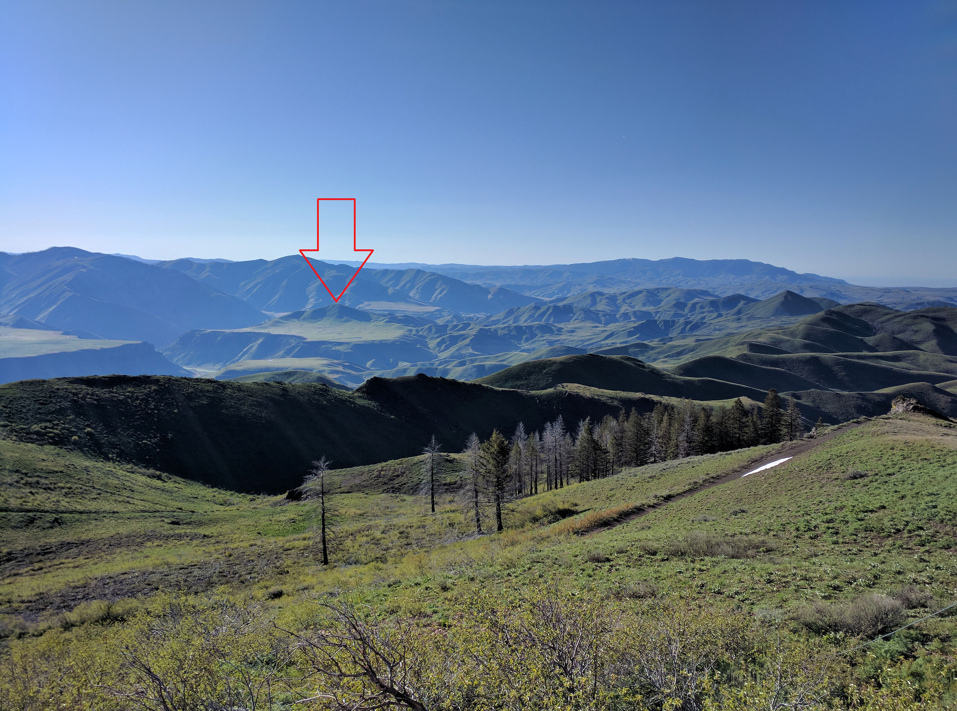
Bridge Peak as viewed from Danskin Peak.
The 2 routes set out below share the last 4 miles which, ironically, DESCENDS northeast to the peak via a bike-able primitive double-track road thru rolling grassland, which is equipped with small ponds making for an almost alpine feel. Once the road reaches gated private property, simply cross-country to the summit for the last half-mile or so.
Routes
Danskin Southeast Ridge Trail #143A01
Thoughts: My favorite back-country route in the southern portion of the range; views are stunning, route finding is an adventurous blast, and the solitude is magnificent.
West Ridge
Thoughts: Can bag Peak 5913/Cayuse Peak along the way; views are fantastic.
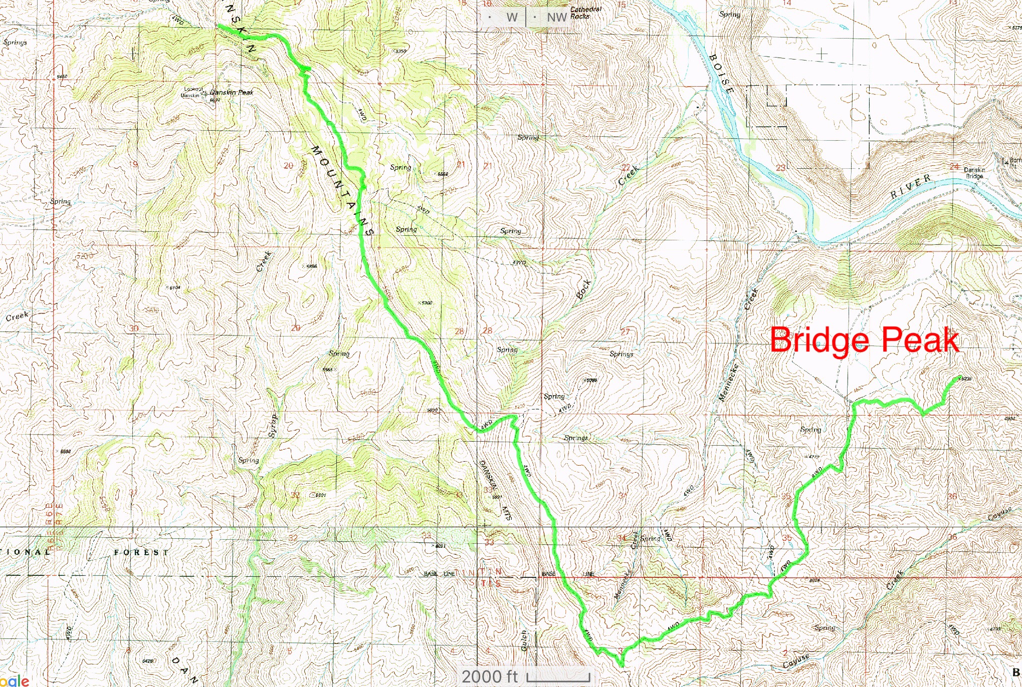
GPS track.
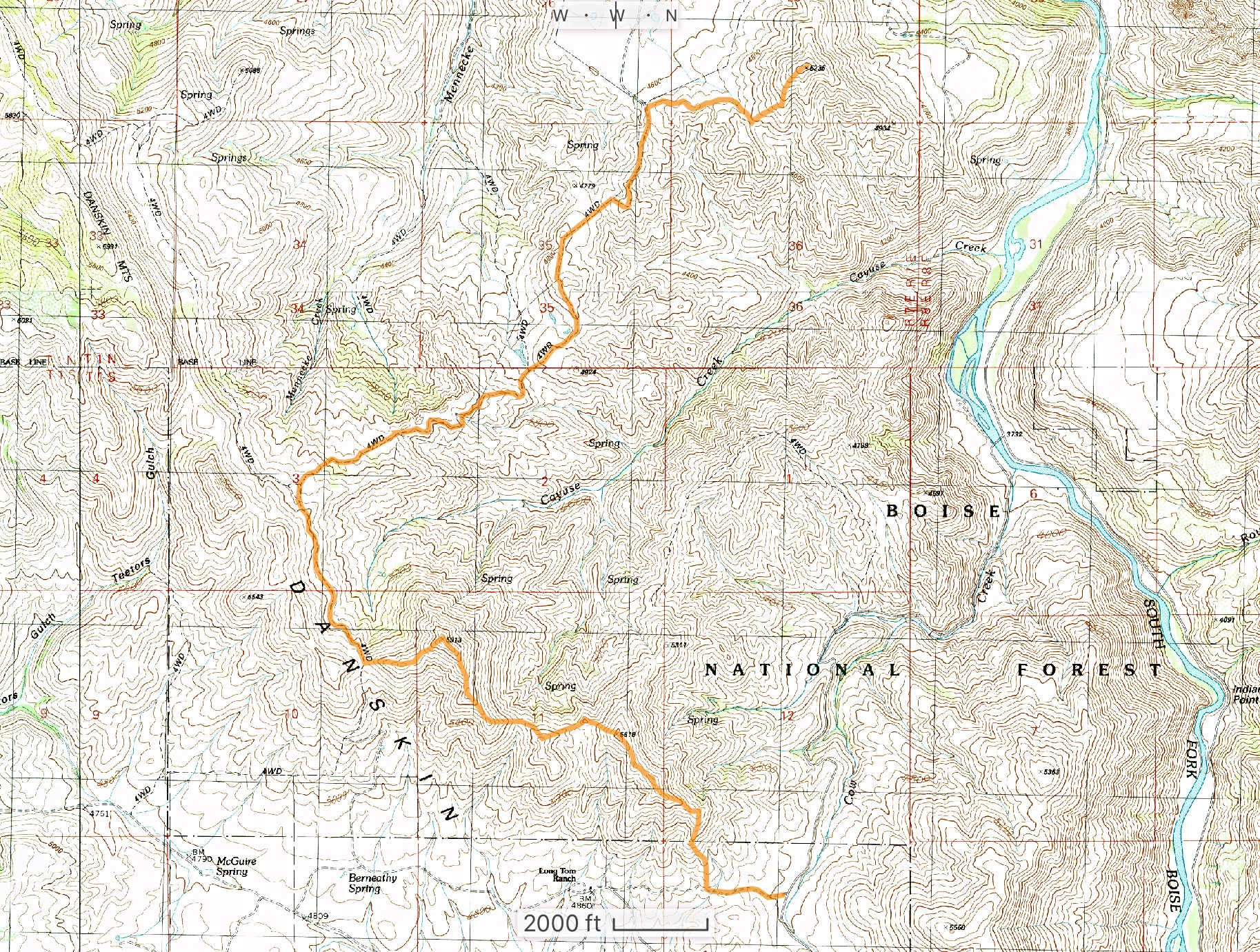
GPS track.
Additional Resources
Regions: Boise Mountains->Danskin Mountains->WESTERN IDAHO
Mountain Range: Boise Mountains
Longitude: -115.56769 Latitude: 43.38801