Elevation: 6,420 ft
Prominence: 440
This peak is not in the book. Published November 2021
Peak 6420 is a hill that towers over Mill Creek, northwest of Challis. Given the preponderance of private property in this area, the only public access is from Mill Creek Road. Even so, you must avoid a private ranch along Mill Creek. Consult a land management map to stay legal. This entire hike is on BLM land. USGS Pats Creek
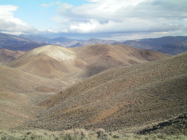
Peak 6420 as viewed from the south. The middle hump (just right of center) is the high point. The whitish hump is the [lower] west summit. Livingston Douglas Photo
Access
This is the first leg of a 2-peak adventure that includes Peak 6420 and Peak 6758. It covers 8.0 miles with 2,675 feet of elevation gain round trip.
From US-93 at the north end of Challis, turn left/west onto [signed] Clinic Avenue. Follow Clinic Avenue as it goes west briefly, then jogs north briefly, then heads west to a “T” junction with [unsigned] Challis Creek Road. This junction is 0.4 miles from US-93. Turn right/north onto Challis Creek Road and drive 5.2 miles to a poorly-signed junction with Mill Creek Road/FSR-079. Turn left/south onto well-graded Mill Creek Road and drive 1.2 miles to a signed junction with Jeffs Flats Road/FSR-079. Park at this junction (5,450 feet).
Northwest Ridge, Class 3
The Climb
From the road junction, get a good look at the open, steep, sagebrush-and-gravel terrain that leads south-southeast up a cone-shaped hump at the north end of the northwest ridge. This steep slope is the first, and most challenging, leg of this climb of Peak 6420. But first, you must find a way across the willow-clogged Mill Creek drainage. Walk about 50 yards upstream on Mill Creek Road to a gated closure. Leave the road and follow the north/public side of a fence row down across Mill Creek and up to a fence corner.
Remember this fence corner and the fence row that heads due south from here. It is critical in staying on public land on the return back to your vehicle. From the fence corner, climb up a steep sagebrush slope that leads to the aforementioned cone-shaped hump. Stay left/north to avoid open, steep scree faces. Focus on areas of sagebrush where you can gain some footing (and handholds). Higher up, the slope steepens and the terrain is very loose gravel. You may be on all fours here.
Grab sagebrush to help pull yourself upward and to not slip down the slope (Class 3). Once on the first ridge hump, it is a cruise south along the ridge crest on easy scrub and gravel, with a few ups and downs. The summit is off to the left/east, so skirt the left/north side of a final ridge hump to reach a broad saddle and an old 2-track road. Hike east up the 2-track road to the summit ridge crest and walk a short distance south to the high point. Point 6411 is a lower hump to the east. It is not the true summit. There was no summit cairn so I built a modest one.
The steep initial scramble requires getting up to the top of the cone-shaped hump in the center of the photo. This view is from the road junction where the hike begins. Livingston Douglas Photo
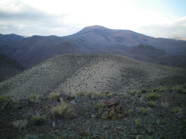
View from the summit of Peak 6420 with its newly-built cairn. The [lower] west summit is in mid-ground with the whitish gravel/scree. Livingston Douglas Photo
South Ridge, Class 2
The Descent
From the summit, walk north along the ridge crest to the 2-track road. Follow it left/west down to a saddle then southwest up onto the west summit, which is a ridgeline. Head south along the weaving ridgeline down to a saddle at the head of a drainage (and an old 2-track road) that comes up from the Mill Creek drainage. Climb up over Point 6132 on the way there. The ridge terrain is easy, open scrub and presents no problems. The 5,980-foot saddle is the connecting saddle with Peak 6758 and concludes the first leg of today’s 2-peak journey. Peak 6758 is up next.
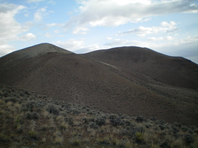
Looking back up at the weaving south ridge (descent route) from the saddle at its base. The summit is the hump right of center. Livingston Douglas Photo
Additional Resources
Regions: Eastern Salmon River Mountains->Salmon River Mountains->Southeast Corner Peaks->WESTERN IDAHO
Mountain Range: Eastern Salmon River Mountains
Longitude: -114.28529 Latitude: 44.28529