Elevation: 7,660 ft
Prominence: 360
This peak is not in the book. Published November 2020
Peak 7660 is a hidden summit that is tucked underneath its massive neighbor to the northeast, Caribou Mountain (9,803 feet). It sits above the North Fork Creek to is east and is thickly forested with lots of brush to boot. The summit is an almost-impenetrable flat area of thick brush. Wear your pants and leather work gloves for this one. Peak 7660 is rarely climbed. Even the wild animals avoid this summit. USGS Caribou Mountain
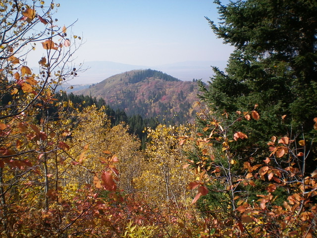
Reclusive Peak 7660 as viewed from the northeast. The open, brushy summit cap is behind the narrow section of pine forest. Livingston Douglas Photo
Access
From the [signed] junction of ID-34 and Grays Lake Road at the southeast corner of Grays Lake, reset your odometer and drive north on Grays Lake Road. This road is paved for the first couple of miles. At 5.6 miles, reach a signed junction with Eagle Creek Road. Turn right onto Eagle Creek Road (which becomes FSR-119). At 6.5 miles, reach the Caribou National Forest boundary. At 6.6 miles, reach a sharp right turn in the road at a dispersed camping area and the [signed] trailhead for the North Fork Trail/FST-451 (an ATV trail/road). Park here (6,650 feet).
East Shoulder, Class 2
The Climb
From the trailhead, hike up the [very rough] FST-451 for about a mile to the 2nd crossing of North Fork Creek at about 6,950 feet. Do not cross to the right/east side of the creek here. Instead, bushwhack west up an obvious shoulder. This is the east shoulder of Peak 7660. The initial bushwhack is steep and unforgiving. It is a combination of dense aspens and thick brush. Push upward and westward through this mess to reach open terrain at about 7,150 feet. The brush is easier now, but this won’t last. Higher up, the brush and willows are tall and dense.
Thankfully, there is a game trail to help you advance upward through this section. The shoulder morphs into a face higher up. When you can’t go any higher, you’ve reached the flat, open summit area. It is a dense plateau of wickedly thick brush and scattered aspens. There is a notable patch of pine forest to the north of the open summit area. The USGS topo map fails to show that the summit area is NOT forested.
It is hard to find a particular “high point” up here and, needless to say, there is no summit cairn. There are no rocks and there is not a stitch of open ground upon which to build one anyway. There are some views from the summit area but the aspens do their best to block your visuals. When you see the magnificent open terrain on Caribou Mountain to the northeast, you’ll wish you were there. Well, that’s our next stop so your dream will come true.
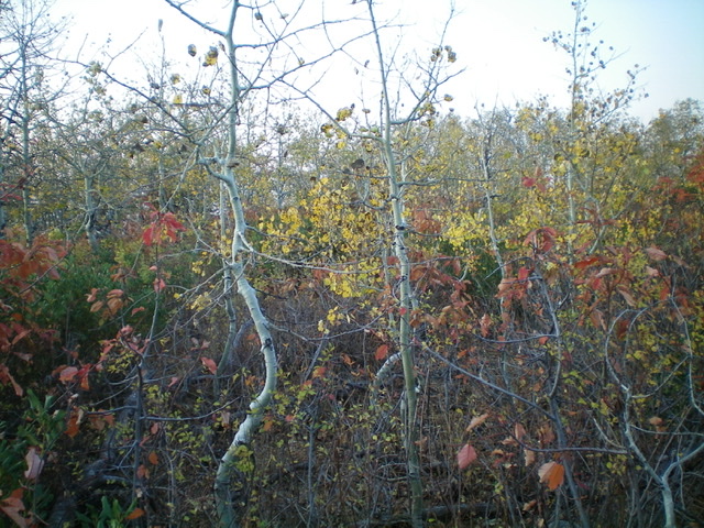
The aspen- and brush-covered summit cap of Peak 7660. You can barely walk around up here. Livingston Douglas Photo
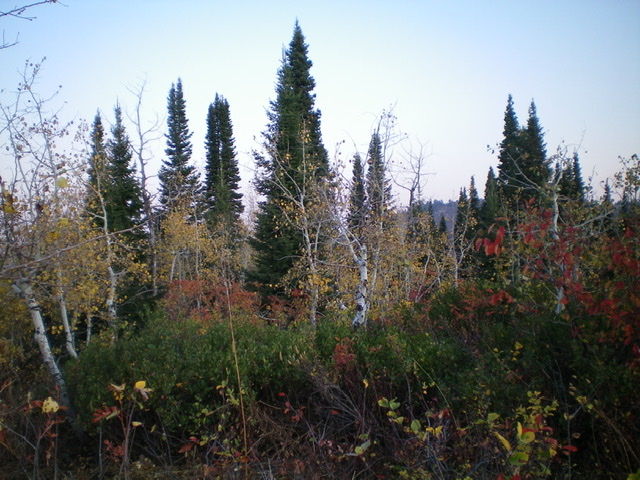
Another view of the summit area of Peak 7660, looking north at the nearby pine forest. Livingston Douglas Photo
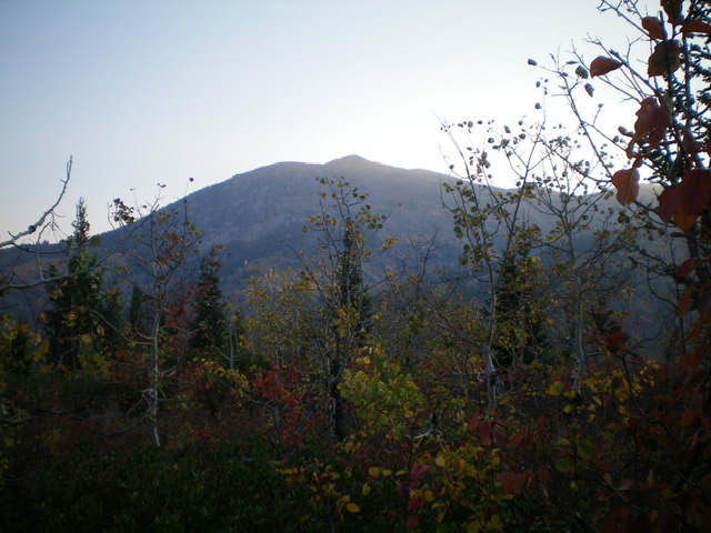
Caribou Mountain as viewed from the summit of Peak 7660. Oh, how I wish I was up there in open, brush-free terrain! Livingston Douglas Photo
North Ridge, Class 2
The Descent
From the summit, descend the north ridge and quickly find a game trail near the ridge crest. Once you leave the summit cap, the brush is more reasonable as well, which is probably why there is a game trail HERE and NOT on the summit cap. Bushwhack down through the forest to reach a saddle at 7,300 feet. From the saddle, descend east through a STEEP, brushy forest to quickly reach the North Fork Creek and the ATV trail (FST-451). Follow the rugged, messy trail (which at times has the creek running all over it) upward to climb the south ridge of Caribou Mountain. Please refer to the Caribou Mountain posting for details on that climb.
Additional Resources
Regions: Caribou Range->SOUTHERN IDAHO
Mountain Range: Caribou Range
Longitude: -111.34529 Latitude: 43.07709