Elevation: 7,821 ft
Prominence: 641
This peak is not in the book. Livingston Douglas added new photos, a new access point, and a new route which, unlike my route, is self propelled. Updated November 2023
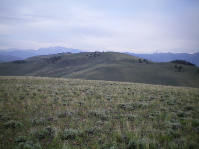
Peak 7821 (dead center) as viewed from the northeast. Livingston Douglas Photo
This peak is located south of Peak 7794. The two peaks are connected by a 4WD road. USGS Bald Mountain
Access and Route, Class 1
Spar Canyon Road is the primary access for the Northern Boulder Mountain peaks [(D)(1) on Page 243]. Spar Canyon Road can be accessed from US-93 in the east or from East Fork Salmon River Road in the west. The road is maintained except during the Winter. It is subject to occasional flash floods and can be difficult to drive when wet. All of the side roads departing from the Spar Canyon Road require high-clearance vehicles and 4WDs are recommended.
To reach the 4WD road that leads to Peak 7794 from US-93, follow Spar Canyon Road west for 7.0 miles to the junction for Bradshaw Basin Road. To reach this junction from the west, follow East Fork Salmon River Road south from ID-75 for 4.1 miles, turn left/east, and follow Spar Canyon Road east for 7.7 miles. Follow Bradshaw Basin Road north for 1.8 miles. Turn left on the 4WD road that leads past the south side of Peak 7891 and continues onto the summit area of Peak 7794. From the summit of Peak 7794, the road drops down into the saddle below Peak 7821 and then climbs steeply to the summit of Peak 7821. Sorry, I didn’t record the distance.
Access roads for Peak 7794 and Peak 7821. 4WD required.
Southeast Ridge by Livingston Douglas
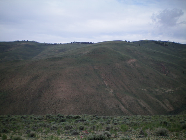
Peak 7821 and its magnificent southeast ridge in mid-ground (lower left to upper right). The summit hump is well right of center. Livingston Douglas Photo
Access
If you are unable to drive up Bradshaw Basin Road (the Lopez Route), this is a good alternative route for hikers. From East Fork Road, drive 2.8 miles northeast up Spar Canyon Road to an unsigned junction with a 2-track road (the second of two unsigned junctions that are only 0.1 miles apart). Park/camp at the base of this 2-track road. Given the nearby cattle cistern, expect a visit from a herd of cows.
This junction is at 6,125 feet and 44⁰14’29”N, 114⁰14’19”W. This is the first leg of a 2-peak adventure that includes Peak 7821 and Peak 7794. It covers 8.0 miles with 2,125 feet of elevation gain. It climbs two magnificent open ridges in the Boulder Mountains on the north side of Spar Canyon Road. I highly recommend it. From Peak 7821, follow the ridge road north to a connecting saddle then continue northeast up the ridge road to the summit of Peak 7794. The Class 1 ridge road is already discussed in this posting.
Map Errors
The USGS topo map fails to show the first road junction (and 2-track road) referenced in the Access Section. The USGS topo map incorrectly positions the 2-track road that heads up to the high ridge. The actual road goes straight/north-northeast at 6,200 feet at a prominent fork in the canyon. It does NOT go left/northwest up the left fork as the USGS topo map shows. There is no road there.
The actual road reaches a ridge saddle east of Peak 7794 at 7,220 feet and a “T” road junction with the ridge road. Surprisingly, a section of the “left fork” road still exists up near the high ridge crest and is visible if you climb the southwest ridge of Peak 7794. Unfortunately, it soon disappears into nothingness. The USGS topo map also fails to show a junction and 2-track road that heads west along a ridge from the summit of Peak 7794.
Southeast Ridge, Class 2
The Climb
Scramble northwest then north then northwest up easy scrub/grass on the meandering, mostly-rounded ridge crest to reach the open summit of Peak 7821. Keep the deep, narrow gulch on your right/east side at all times. Don’t be tempted to wander left/west onto the south ridge which is a good distance away and only adds needless mileage to the climb. The summit of Peak 7821 has a modest cairn alongside a fallen tree log. To continue on to Peak 7794, follow a 2-track ridge road north then northeast to a 7,420’ saddle. From the saddle, hike northeast up the 2-track ridge road to the summit of Peak 7794.
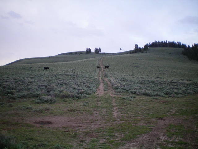
Looking back up the north ridge from the saddle at its base. The summit is left of center. Livingston Douglas Photo
Additional Resources
Regions: Boulder Mountains->EASTERN IDAHO
Mountain Range: Boulder Mountains
Year Climbed: 2022
Longitude: -114.25659 Latitude: 44.25659