Elevation: 7,891 ft
Prominence: 631
This peak is not in the book. Livingston Douglas added a new route, an alternative access point, and new photos to this page. Updated November 2023
Peak 7891 is located on the west side of Bradshaw Basin due north of Bradshaw Peak. All of the Northern Boulder Mountain peaks provide great views of the surrounding country. This peak is a short climb to experience the views of six mountain ranges. USGS Lone Pine Peak
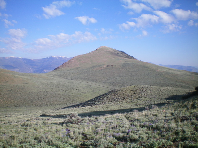
Peak 7891 as viewed from Bradshaw Peak
Access
Spar Canyon Road is the primary access for the Northern Boulder Mountain peaks [(D)(1) on Page 243]. Spar Canyon Road can be accessed from US-93 in the east or from East Fork Salmon River Road in the west. The road is maintained except during the Winter. It is subject to occasional flash floods and can be difficult to drive when wet. All of the side roads departing from the Spar Canyon Road require high-clearance vehicles and 4WDs are recommended.
To reach the 4WD road that accesses the route described below from US-93, follow Spar Canyon Road west for 7.0 miles to the junction for Bradshaw Basin Road. To reach this junction from the west, follow East Fork Salmon River Road south from ID-75 for 4.1 miles, turn left/east, and follow Spar Canyon Road east for 7.7 miles. Follow Bradshaw Basin Road north for 1.8 miles. Turn left on the 4WD road that leads to the pass on the south side of Peak 7891. Park here.
South Slopes, Class 2
From the parking spot, you can follow numerous lines up through the sagebrush toward the summit. This quick, easy ascent covers 0.8 miles with 515 feet of elevation gain round trip.
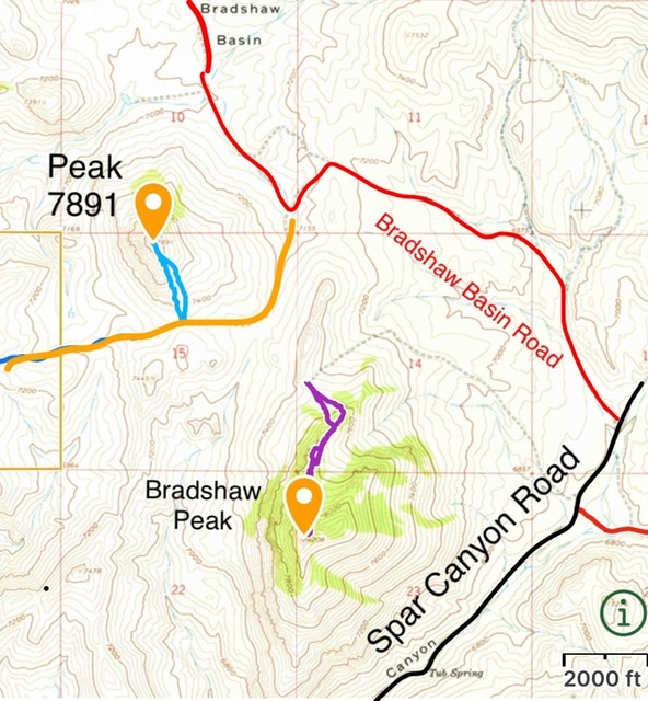
This map show the access to Peak 7891’s south slopes
Southeast Ridge by Livingston Douglas
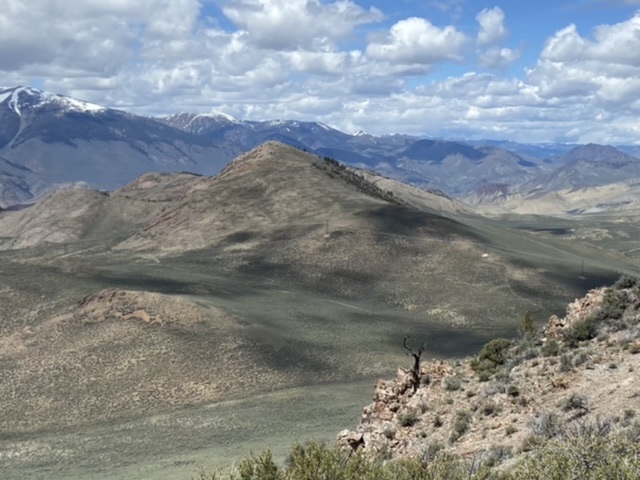
Peak 7891 as viewed from the southeast. My ascent route climbs the ridgeline right of center then continues diagonally left up to the summit. Livingston Douglas Photo
Access
If you are unable to drive up Bradshaw Basin Road, this is a good alternative for hikers. I hiked up this unused, overgrown 2-track road from Spar Canyon Road. It is a more direct road if climbing either (or both) Bradshaw Peak and Peak 7891. Drive 7.2 miles northeast up Spar Canyon Road from East Fork Road and park at an unsigned junction with a 2-track road (shown on the USGS topo map) that heads left/northwest. This junction is at 6,785 feet and 44⁰16’24”N, 114⁰10’05”W. This is the first leg of a 2-peak adventure that includes Peak 7891 and Bradshaw Peak (8,208 feet). It covers 6.5 miles with 2,325 feet of elevation gain.
Map Errors
The USGS topo map and the National Forest Map fail to show an old 2-track road that heads west then northwest to skirt the west side of a narrow, rocky ridge prow. It then descends west to a saddle at the base of the southeast ridge of Peak 7891.
Southeast Ridge, Class 2
The Climb
From the road junction, hike northwest up the 2-track road to a sharp left/southwest bend in the road. It now follows a dry gully up to a bare saddle on the west side of the north ridge of Bradshaw Peak. This saddle is at the head of the dry gully and is at about 7,475 feet. From this saddle, there are two options. First, follow the road north then northwest as it skirts the east side of a rocky ridge prow and then bends left/west to descend to a saddle at the base of the southeast ridge of Peak 7891. Alternatively, descend northwest directly to the aforementioned saddle through sagebrush.
From the 7,260-foot saddle at the base of the southeast ridge, follow the remnants of an old 2-track (now a foot path) up to a set of powerlines with large piles of whitish talus at their base. These powerlines are on the crest of the southeast ridge. Scramble northwest up the gapped scrub and minor cliff bands on the ridge crest to reach the rocky summit of Peak 7891. The summit has a modest cairn. From the summit, return down the southeast ridge to the saddle at its base. This saddle is the low point in the traverse to Bradshaw Peak and concludes the first leg of today’s 2-peak adventure. Bradshaw Peak is up next.
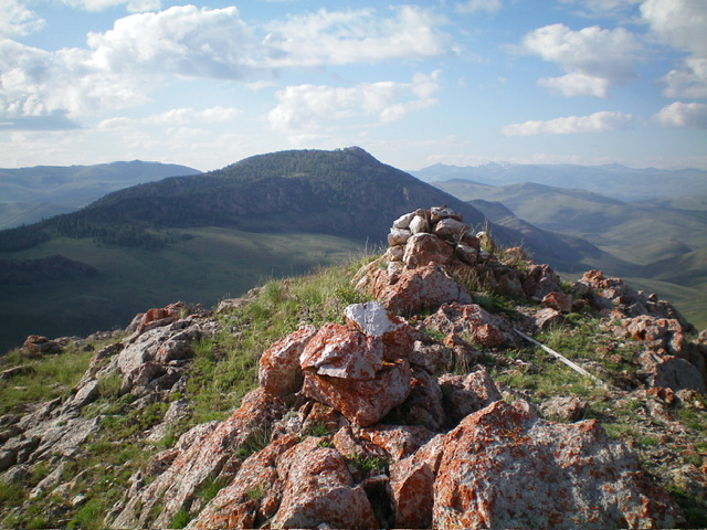
The summit of Peak 7891 with Bradshaw Peak in the distance. Livingston Douglas Photo
Additional Resources
Regions: Boulder Mountains->EASTERN IDAHO
Mountain Range: Boulder Mountains
Year Climbed: 2022
Longitude: -114.20419 Latitude: 44.28949