Elevation: 7,921 ft
Prominence: 501
This peak is not in the book. Livingston Douglas climbed the peak via a long route from Muldoon Canyon. His ascent and descent routes are set out below. He descended the peak’s southeast ridge which ends at a 7,400-foot saddle west of Bell Mountain. This saddle can be reached by the road to Bell Mountain. Updated September 2020
Peak 7921 is located northwest of Bell Mountain. The peak sits at the head of McFates Canyon, a side canyon emanating from Muldoon Canyon, east of Bellevue, ID. It is the high point on a narrow ridge that separates Sharps Canyon from McFates Canyon. This area is a patchwork of BLM land, State of Idaho land, and private land. Consult the BLM Fairfield map to stay out of trouble. USGS Seamans Creek
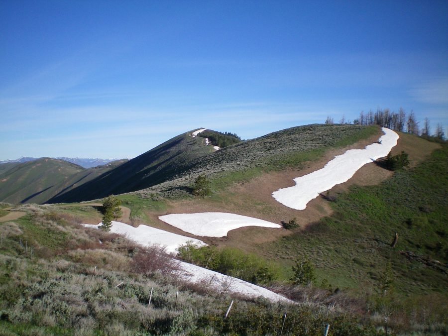
Peak 7921 (dead-center) and its southeast ridge as viewed from the base of the west ridge of Bell Mountain. Livingston Douglas Photo
Northeast Spur/Northwest Ridge, Class 2
Access
From the junction of ID-75 and Pine Street in Bellevue, drive east on Pine Street (which becomes Muldoon Canyon Road) for 5.9 miles to an unsigned junction with Sharps Canyon Road, a BLM road. Park near this junction in a pullout area (5,800 feet). The toe of the northeast spur of the northwest ridge is at this junction, on the west side of Sharps Canyon Road.
The Climb
From the parking pullout, bushwhack west through steep sagebrush then a mix of sagebrush/pines to reach the crest of the northeast spur. Climb south then southwest up the spur on a ridge thick with pines and scrub (not pleasant) to finally reach open terrain at Point 7214. The northeast spur ends here as it merges into the northwest ridge.
Scramble southeast up the undulating northwest ridge. You will soon find an old 2-track jeep road on the ridge crest. Follow this old road all the way to the northwest summit of Peak 7921. The northwest summit (7,921 feet) looks and measures (by altimeter readings) slightly lower than the southeast summit (7,916 feet). Stand on both potential summits just to be sure, even though they are both measured summits. Neither of these ridge humps has a summit cairn on it.
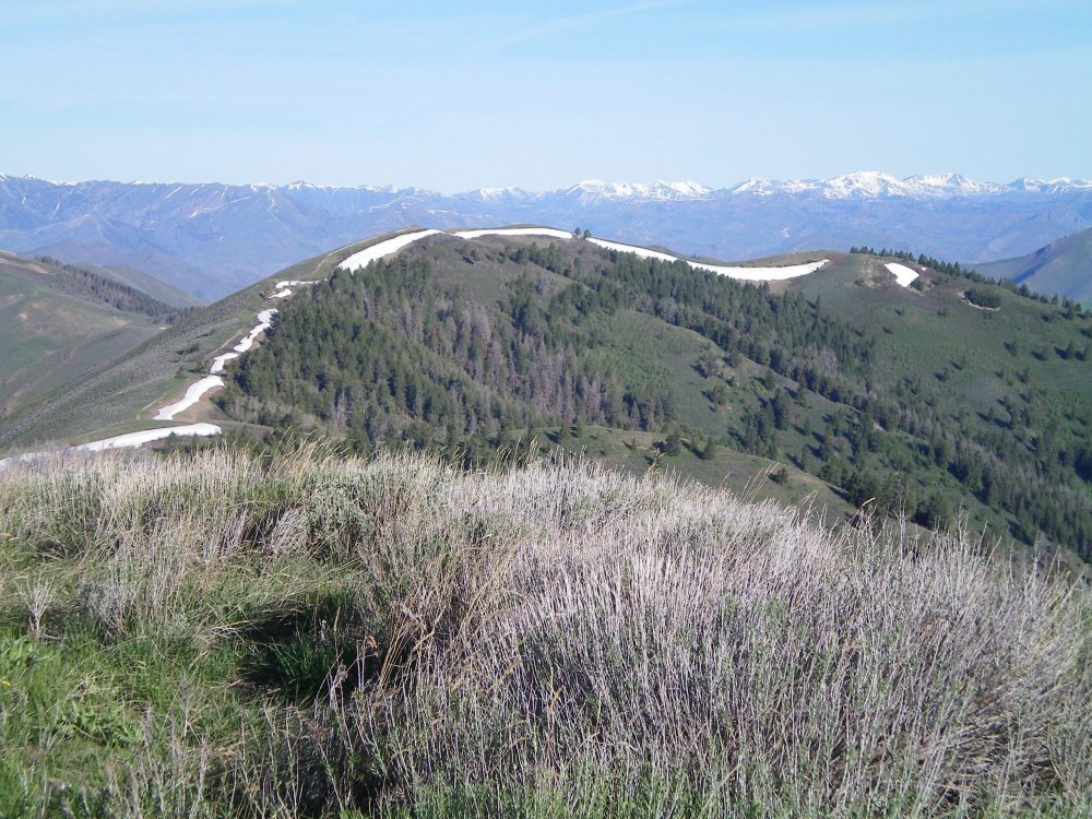
Peak 7921 as viewed from the summit of Bell Mountain. Livingston Douglas Photo
Southeast Ridge, Class 1
Access
Same as for the north ridge. This is the first leg of a ridge traverse from Peak 7921 to Bell Mountain (7,988 feet).
The Descent
From the northwest summit, hike along the 2-track jeep road as it follows the ridge southeast up over the southeast summit. It becomes a better road and continues along the ridge all the way down to a road junction at the head of Sharps Canyon. The Sharps Canyon BLM Road crosses the ridge here. This is the base of the southeast ridge.
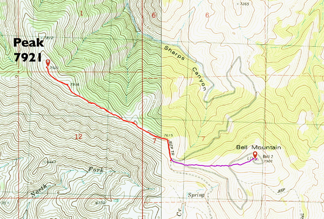
The southeast ridge route is shown in red. Round trip is 2.65 miles with 450 feet of elevation gain.
Additional Resources
Regions: EASTERN IDAHO->Pioneer Mountains
Mountain Range: Pioneer Mountains
Year Climbed: 2020
Longitude: -144.14379 Latitude: 43.44149