Elevation: 8,420 ft
Prominence: 1,145
This peak is not in the book. Published November 2019
Peak 8420 towers over Ennis Gulch. It rises over 3,000 feet from the 5,400-foot mouth of the gulch. It is a BIG mountain with a west ridge that includes another ranked summit (Peak 6216/Ellis Hill). Peak 8420 is guarded by cliffs on all sides. Its weakness is its relatively-easy, LONG south ridge, which arises from near the mouth of Ennis Gulch. If you’re a shed hunter, you will love this mountain. I found two elk sheds on the south ridge and two mule deer sheds on the east face of the south ridge. The northwest summit is the high point. USGS Ennis Gulch
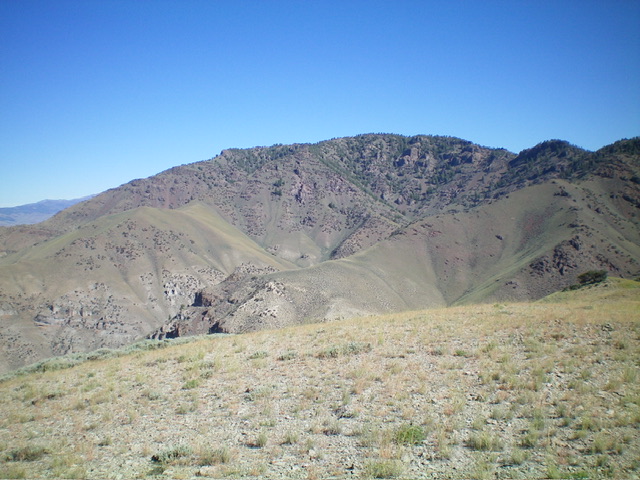
Peak 8420/Ennis Gulch Peak and its rugged east face. The skyline is the south ridge which was my descent route. Livingston Douglas Photo
Southeast Shoulder/South Ridge, Class 3+
Access
Ennis Gulch Road/FSR-130 is located 1.5 miles south of US-93 (at Ellis, ID) on the Pahsimeroi Highway. It has a large BLM sign at its junction with the highway. Drive east on the dirt road and ignore any and all side roads. The road bends left/northeast after about a mile. Continue as far as you can go and park. The road gets narrow and rougher as you go, and it crosses some narrow gullies where you might bottom out your vehicle. From your parking spot, walk east to the base of the mountains. Continue right/south on the road as it follows the base of the mountains to reach the mouth of Ennis Gulch (5,400 feet). This is where the climb begins.
The Climb
From the mouth of Ennis Gulch, follow the jeep road (Ennis Gulch Road/FSR-130) up the center of the canyon. At about ¼-mile up the road, you reach a fork in the canyon and an unsigned junction. Go right/east here to remain in Ennis Gulch. Continue up the road for just under a mile to reach a flat meadow and another unsigned junction. Go left/north here to continue up Ennis Gulch. Hike up the road just over a mile to where the road becomes very overgrown with tall grass and disappears at another fork in the canyon with a massive rock buttress in the center of the fork. There is a beautiful meadow here. This is the end of the road/trail. The elevation here is about 6,700 feet.
From this fork, scramble northwest up a very steep face to gain the southeast shoulder. The loose gravel and scrub will challenge you. Once on the shoulder, climb northwest up the ridge crest through loose scree/gravel, sagebrush, and mountain mahogany. There is a prominent gully to your right, separating you from the east ridge. There is a series of ugly gullies to your left that separate you from the south ridge. I knew I was in trouble at this point because I would have a difficult time getting to either the south ridge or the east ridge. Well, I made this bed, so I must lie in it.
Worse yet, there are impossible cliff bands ahead that spell a dead-end for the southeast shoulder. When you reach 7,300 feet, the cliff bands block any further advance. However, you can move to the left/west and work your way up through ledges, narrow chutes, and up steep rock to make your way over to the south ridge. The combination of steep rock and brush/scrub make this a difficult task, but it is do-able. Your general direction here is “left and up.” Cross some steeply-angled scree/gravel fields when you are blocked by impossible cliff faces. When you finally reach the south ridge, you will be greatly relieved. You should reach the ridge just below, and south of, Point 8124.
Skirt the left/west side of rocky Point 8124 then work your way up the ridge through more rocky outcrops, dense forest and pine bushes, and loose shale scree. You will soon reach the flatter summit area and be unsure as to whether the true summit is to the right/northeast or left/northwest. I visited both potential summits and the northwest summit is clearly the high point. Go left/northwest here. Traverse across undulating open sagebrush terrain to reach the cairned high point. The summit area is mostly sagebrush but the high point is a minor rocky point.
South Ridge, Class 2
Access
Same as for the southeast shoulder/south ridge
The Descent
From the summit, return southeast to the top of the south ridge. Descend south on the ridge through an initial section of thickly forested, narrow, rocky terrain. This is the crux of the descent. Once you pass Point 8124, the terrain improves vastly. Pick up a good elk trail here and cruise down the semi-open then open ridge crest all the way to the 5,860-foot level. Exit the ridge here and descend southeast to Ennis Gulch Road/FSR-130. Retrace your road hike back to your parking spot.
Additional Resources
Regions: EASTERN IDAHO->Lemhi Range
Mountain Range: Lemhi Range
First Ascent Information:
- Other First Ascent: Southeast Shoulder/South Ridge
- Year: 2019
- Season: Summer
- Party: Livingston Douglas
Longitude: -113.97179 Latitude: 44.70789