Elevation: 8,598 ft
Prominence: 298
This peak is not in the book. Published February 2020
Peak 8598 is a remote peak located east of Enos Lake and Enos Peak. It sits due south of Jungle Lake. USGS Enos Lake
Access
Take the FH-48/Lick Creek Road north from McCall to the Duck Lake trailhead. The trailhead is located just north of Lick Creek Summit [(B)(3) on Page 136]. The route from the Duck Lake trailhead to Enos Lake involves maintained and poorly maintained trails as well as a lot of difficult cross-country travel. Follow FST-085 north past Duck Lake to its junction with FST-084 [(B)(3)(c) on Page 136]. Hike FST-084 to the top of Lick Creek Crest. Descend down to the small lake at the headwaters of Loon Creek.
From the lake, traverse over to FST-082 [(B)(3)(d) on Page 136]. Follow FST-082 up to South Loon Saddle (8,056 feet). From this saddle, start up the South Ridge of South Loon Mountain. After gaining roughly 200 vertical feet of elevation, begin a climbing traverse across the South Face of South Loon Mountain. Aim for a crossing of the peak’s Southeast Ridge at just over 8,800 feet. Cross the ridge and descend to Enos Lake. See the map below and use the link below to read John Platt’s trip report. This route covers 7.9 miles with 3,250 feet of elevation gain. Note: An alternative route to the upper Loon Creek drainage is to hike to Hum Lake and then from Hum Lake to Loon Creek [(B)(3)(d) on Page 136].
North Ridge, Class 3
Hike from Enos Lake to the base of the Peak 8598’s North Ridge as shown on the map below. Climb the North Ridge to the summit. John Platt reports the round trip from his camp at Enos Lake covered 4.4 miles with 1,814 feet of elevation gain.
John describes the route as follows: “From the big campsite at Enos Lake, follow the South Shore of the lake until you feel like bushwhacking down to the lower lake. We came up a different way than we went down. Open country with varying footing and amounts of brush.
At the lower Enos Lake, follow the Northwest Shore around and cross the outlet. Looking up from there, and following your map, swing climber’s right a bit to shoot through the cliffs and find the hanging valley. Follow that valley until you reach the ridge top overlooking Jungle Lake. Turn right and follow the ridge to the summit. Only the last few feet require anything more than Class 2 and a really good ability to navigate off-trail.”
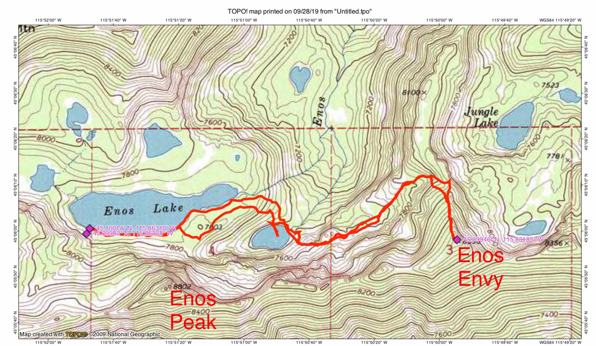
John Platt’s GPS track.
Additional Resources
Mountain Range: Western Salmon River Mountains
Longitude: -115.83189 Latitude: 45.09939