Elevation: 8,730 ft
Prominence: 980

This peak is not in the book. Published January 2023
Peak 8730 is the high point on a ridge on the west side of the extensive Smoky Canyon Phosphate Mining Operation. It is thickly forested but has an open summit. Peak 8730 sits south of Smoky Canyon and north of Pole Canyon in the Webster Range. This is an area that requires difficult forest bushwhacking so be aware. USGS Stewart Flat
The summit of Peak 8730. Livingston Douglas Photo
Access
Same as for Smoky Benchmark. This is the second leg of a 3-peak adventure that includes Smoky Benchmark (8,693 feet), Peak 8730, and Peak 8570.
Map Errors
There are so many map errors in this area, it is ridiculous and navigationally confusing. Both the USGS topo map and the Caribou-Targhee National Forest map fail to show numerous old logging and phosphate mining roads (and road beds) that diagonally criss-cross these mountains. The USGS topo map fails to show ANY roads on the south side of Smoky Canyon Road, including FSR-219 and FSR-213 (which ARE shown on the Caribou-Targhee National Forest map). There are foot trails that follow some of the old road beds. The USGS topo map mis-positions Smoky Canyon Road around the Webster Ridge trailhead. The road crosses a saddle just north of Point 7800+, not just south of it as the map indicates.
North Ridge, Class 2
The Climb
From the 8,509-foot connecting saddle with Smoky Benchmark, bushwhack southeast up the right/west side of a mature pine forest on a game trail that begins in a younger, shorter section of pines. Once on the ridge crest, scramble south to the summit of Peak 8730 on a narrow, flat ridge with thick pines and lots of blowdown and underbrush. The summit is open and has a decent jeep road leading up to it from the south (FSR-213). There was no summit cairn so I built a decent one on the high point.
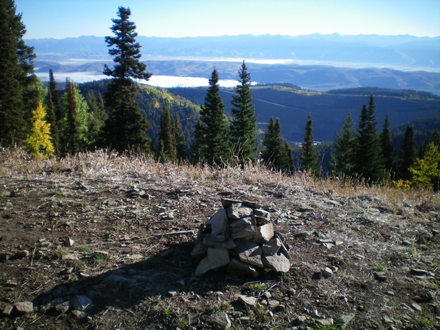
Summit view from atop Peak 8730 with its newly-built cairn. The south end of the ridgeline of Peak 8010 (and its active phosphate mining operation) is in mid-ground. Livingston Douglas Photo
Southwest Ridge, Class 2
The Descent
From the summit, follow FSR-213 south then west to reach a saddle at 8,590 feet located just east of Point 8600+. This saddle has an unsigned “T” junction with FSR-219 which heads north and weaves its way down to Smoky Canyon Road/FSR-110. FSR-219 also heads south then southwest from here. Follow FSR-219 south then southwest to its unceremonious end in an open area with nearby forest at 8,450 feet.
An old 2-track continues south-southeast from here and leads down to the 8,230-foot connecting saddle with Peak 8570 to the south. Finding this 2-track is difficult because it is buried under large amounts of deadfall. Head left/southeast from the end of FSR-219 into the pine forest and look for the 2-track in a gully of sorts. Follow the 2-track south-southeast down to about 50 yards west of a forested saddle with an old 2-track road (not shown on maps) running through it. This old road is not shown on the Caribou National Forest map but is shown on the USGS topo map but is mispositioned on the saddle crossing. It ismostly a foot path now and it comes up from Pole Canyon to the east. The 8,230-foot saddle is the low point between Peak 8730 and Peak 8570. It concludes the second leg of today’s 3-peak journey. Peak 8570 is up next.
Additional Resources
Regions: Peale Mountains->SOUTHERN IDAHO->Webster Range
Mountain Range: Peale Mountains
Longitude: -111.1543 Latitude: 42.6891