Elevation: 8,822 ft
Prominence: 522
This peak is not in the book. Published January 2023
Peak 8822 is the high point on a ridgeline that separates Cow Creek from Horse Creek in the Webster Range. It sits southeast of Diamond Peak (8,696 feet) and north of Webster Canyon. Peak 8822 is most easily climbed from the Webster Creek Trail/FST-112. USGS Diamond Flat
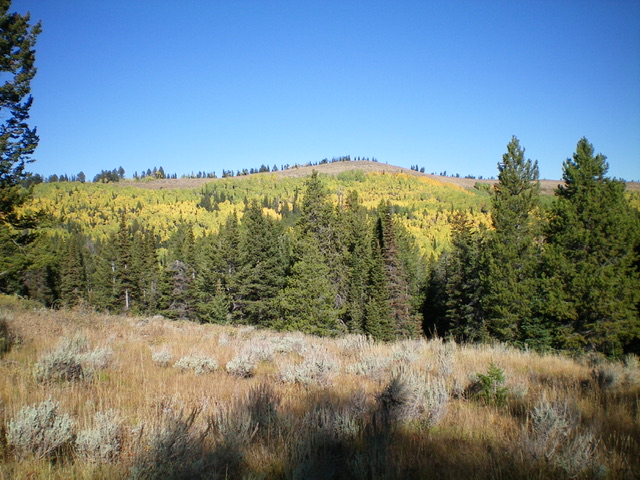
Peak 8822 (dead center) as viewed from the southeast. Livingston Douglas Photo
Access
Same as for Peak 8660. This is the second leg of a 2-peak adventure that includes Peak 8660 and Peak 8822.
Map Errors
The USGS topo map shows only a portion of FST-112. The USGS topo map shows much more open terrain than actually exists, especially on the routes discussed for this peak. Both aspens and pines have grown to fill in most of those open areas, including the “wide open” summit of Peak 8660. This makes reaching Peak 8660 and Peak 8822 a more difficult bushwhacking endeavor.
Southeast Face/South Ridge, Class 2
The Climb
From the 8,340-foot connecting saddle with Peak 8660, bushwhack northwest through a thick aspen/pine forest to reach open scrub terrain above. Use an old use trail in the forest to expedite the forest bushwhack. Once in the open terrain, scramble a short distance up onto the semi-open south ridge. Once on the ridge, head right/north in semi-open terrain then open scrub to the ridgeline summit of Peak 8822. This scrub is somewhat thick sagebrush and other veg. The summit is in open terrain and offers magnificent views of the surrounding area. It had a small, torn-down summit cairn which I rebuilt and enlarged significantly.
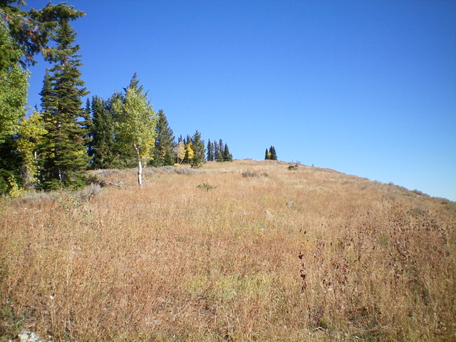
The open, scrub hump summit of Peak 8822 as viewed from high on the south ridge, my ascent route. Livingston Douglas Photo
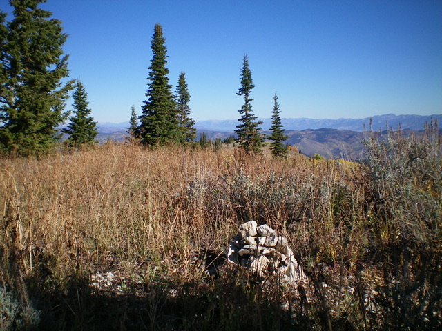
The summit of Peak 8822 with its newly-built summit cairn. Livingston Douglas Photo
South Ridge/Southeast Face/South Gully, Class 2
From the summit, return to the forested 8,340-foot connecting saddle with Peak 8660. From the saddle, descend southwest on a forested face (with a fair amount of deadfall) then enter a dry gully and follow it southwest then south down to Webster Creek and the Webster Creek Trail/FST-112. The forested descent in the gully is a mixed bag. It has some easy sections with short grass/scrub and minimal deadfall. Other sections are narrow and steep with large downed trees in the gully. Hike east on the seldom-used, poorly-maintained Webster Creek Trail for about four miles to reach the trailhead. The trail is narrow, overgrown, and has a fair amount of deadfall on it. It is a disgrace. The trail skirts the left/north side of a series of beaver ponds lower down.
Additional Resources
Regions: Peale Mountains->SOUTHERN IDAHO->Webster Range
Mountain Range: Peale Mountains
Longitude: -111.1565 Latitude: 42.7747