Elevation: 9,139 ft
Prominence: 319
This peak is not in the book. Published November 2022
Peak 9139 is located at the north end of a forested ridgeline that separates the Salmon River drainage from the Frenchman Creek drainage in the Sawtooth Range south of Stanley. USGS Frenchman Creek
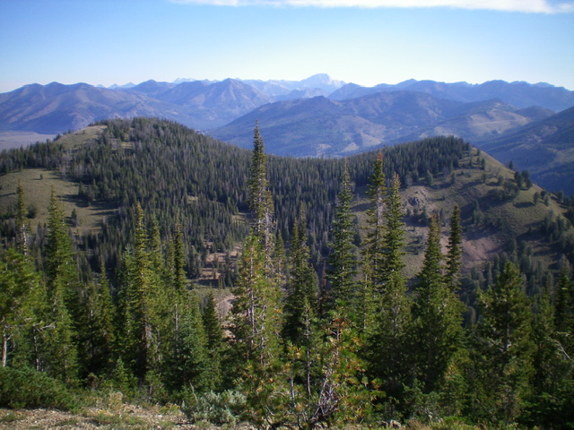
Peak 9139 (left hump) and Point 9048 (right hump) as viewed from Peak 9345 to the south. Livingston Douglas Photo
Access and Map Errors
From ID-75, turn left/south onto [signed] Salmon River Road/FSR-215 and drive 3.1 miles to the road’s end at the Mule Creek Trailhead/FST-198, which is just past the Chemeketan Campground (a group campground by reservation only). The trailhead is a large turnaround with ample parking (7,550 feet). GPS coordinates: 43⁰50’48”N, 114⁰45’09”W. The USGS map shows the Salmon River Road going much farther up the Salmon River Valley than it actually does. The road has been gone for so long that there aren’t even any remnants of it after hiking a short distance from the trailhead. There is only a narrow footpath heading up the Salmon River (FST-198). And, perhaps strangest of all, the trail is called the Mule Creek Trail even though it follows the Salmon River.
Mule Creek is a small creek on the south side of the major east-west ridge crest that separates Blaine County from Camas County, the same ridge crest upon which Robbery Peak is located. You won’t even get close to Mule Creek on this hike. Yes, at 3.3 miles, there is a trail junction where FST-198 heads right/southwest to climb up over the ridge crest then descend a ridge well east of Mule Creek then descends a gully east of Mule Creek to reach the West Fork Big Smoky Creek. FST-198 never follows, or even gets close to, Mule Creek. At the aforementioned trail junction, the main trail becomes FST-072 and heads south up over the major east-west ridge crest to drop into the Big Smoky Creek drainage.
Southeast Ridge, Class 3
The Climb
From the trailhead, hike south up FST-198/Mule Creek Trail for about 0.7 miles to the north end of the second open meadow. This meadow is dry but, just below it, the lower meadow is a wet mess of willows, marshes, and beaver ponds. Thankfully, the Salmon River runs underground in this second meadow. The upper end of the second meadow has a small stream in it (the Salmon River) that is easy to jump. Leave the trail and head west across easy grass/scrub then sagebrush and some forest blowdown to reach the toe of the southeast ridge of Peak 9139. The toe is located on the right/north side of a prominent dry gully/drainage. Enter the forest and climb steeply up a slope of loose scree/gravel, scrub, and scattered pines with a fair amount of deadfall to contend with. This initial ridge section is much steeper than the USGS map indicates.
Keep grinding northwest up the steep ridge, staying in any semi-open or open terrain when possible. The ridge gains definition and an elk trail emerges on or near the ridge crest. Scramble up a short section of Class 3 ridge outcrops at about 8,600 feet in open scrub. Once past the rocky ridge outcrops, continue up the steep, mostly-forested ridge to Point 9048. From this elk-inhabited point, descend west-northwest through thick pine forest (with no visibility) to find a wide, forested saddle with copious blowdown. Bushwhack west then northwest up through thick forest with lots of blowdown to reach easy, semi-open scrub high up.
From there, grind higher to the forested summit area. There was no summit cairn, so I built one. According to my altimeter this is the actual HP of Peak 9139. However, upon descending to the south-southwest, I found an open area at the edge of the forest with a triangulation post (and wiring) in the ground. Although 10 feet lower than the forested high point, this must be the official high point of Peak 9139. So I built a summit cairn here too. Contrary to the USGS map, this area is a vast, open area and is NOT forested. This open area is on the southwest side of the summit of Peak 9139 as positioned on the USGS map.
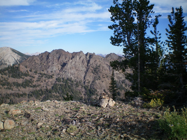
The official high point of Peak 9139. Livingston Douglas Photo
Southwest Ridge, Class 2
The Descent
From the open summit area of Peak 9139, get a good look at Peak 9345, the next objective of today’s multi-peak adventure. Contrary to the USGS map’s representation, the terrain down to the connecting saddle with Peak 9345 is mostly open terrain high up and then becomes thickly forested lower down. The connecting saddle is forested and is hidden. In descending the southwest ridge of Peak 9139, aim for the low end of the forested north ridge of Peak 9345 in order to find the elusive saddle. Descend the open crest of the southwest ridge until it enters the pine forest. Once in the forest, follow a good elk trail on the crest as it descends to the saddle area. Surprisingly, the ridge becomes the narrow saddle and there is no obvious saddle. The elusive 8,820-foot connecting saddle/ridge with Peak 9345 is the terminus of the southwest ridge of Peak 9139. This concludes the first leg of today’s 3-peak adventure. Peak 9345 (Frenchman Peak) is up next.
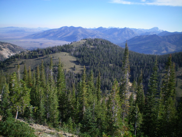
Peak 9139 (dead center) and its southwest ridge (descending diagonally left from the summit hump), my descent route. Livingston Douglas Photo
Additional Resources
Mountain Range: Sawtooth Range
Longitude: -114.77509 Latitude: 43.84679