Elevation: 10,744 ft
Prominence: 650
This peak is not in the book. It is the east summit of officially-named Gilmore Peak. Based on my visual observation, I believed there was a 50/50 chance that it is actually the highest point on the Gilmore Peak massif. My observation was recently confirmed by LiDAR measurements. Gilmore Peak is discussed on Page 304 of the book. For those wishing for more route detail, Livingston Douglas has added more detailed route information, new photos, and a new descent route for those wishing to traverse to Liberty Mountain. He climbed this peak as part of a 4-peak adventure that includes Peak 10723, Gilmore Peak (10,735 feet), Gilmore East, and Liberty Mountain (10,216 feet). It covers 7.5 miles with 3,025 feet of elevation gain round trip. Finally you will find Dean Lords’ Northwest Corner II 5.7 A0 or 5.8 route discussed below. November 2024
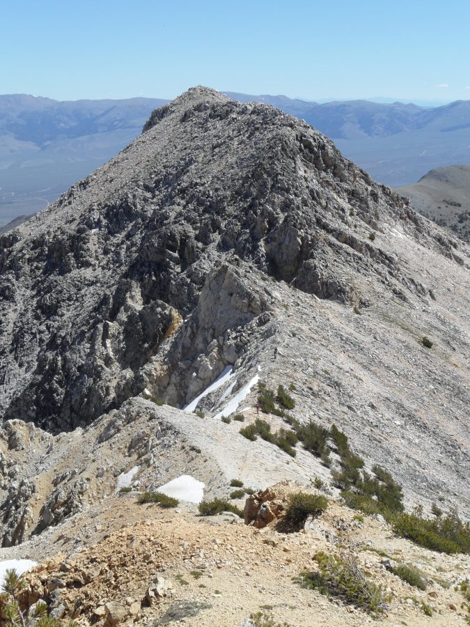
Gilmore East is the high point of the Gilmore Peak massif. My altimeter measured Gilmore Peak and Gilmore East of equal height. However, from every angle at which you can look at these two peaks, Gilmore East is clearly higher (see photo). Gilmore East is an impressive piece of rock. USGS Gilmore
Gilmore East as viewed from Gilmore Peak. John Platt Photo
Access
Same as for Gilmore Peak.
Gilmore Peak to Gilmore East Traverse, Class 2+
The easiest route to the summit is the traverse from Gilmore Peak is a Class 2+ scramble. You will encounter one obstacle on the ridge. Bypass this obstacle on its south side.
Southwest Ridge and Northeast Ridge by Livingston Douglas
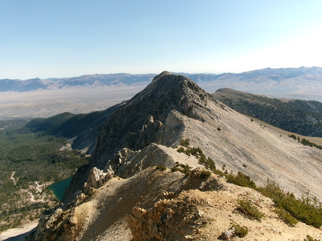
Gilmore East as viewed from Gilmore Peak to its southwest. Livingston Douglas Photo
Access
Same as for Peak 10724 and Gilmore Peak which climbed as part of his Meadow Lake cirque traverse of Peak 10724, Gilmore Peak, East Gilmore Peak and Liberty Mountain.
Southwest Ridge, Class 3
The Climb
From the 10,540-foot connecting notch with Gilmore Peak, climb northeast up blocky (but stable) quartzite face rock and boulders to reach the rocky summit perch of Gilmore East. The summit had no cairn so I built one on top of the highest boulder. While the chunky ascent from the connecting notch was a bit tedious, it took only 16 minutes to do the complete ridge traverse from Gilmore Peak to Gilmore East.
Northeast Ridge, Class 3
The Descent
From the rocky summit, descend a steep, tedious slope of Class 2+ boulders and talus to reach flatter ground below. From there, traverse north-northeast across several narrow, blocky ridge humps (Class 3) to reach the gentle, wide connecting saddle with Liberty Mountain (10,216 feet). This 9,900-foot connecting saddle concludes the third leg of today’s 4-peak journey. Liberty Mountain is up next.

Gilmore East (summit is right of center) as viewed from its connecting saddle with Liberty Mountain. The northeast ridge (my descent route) is left of center and curls right to reach the rocky summit perch. Livingston Douglas Photo
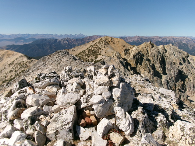
The summit cairn atop Gilmore East with Gilmore Peak in the distance (dead center). Livingston Douglas Photo
West Face to Meadow Lake, Class 2+
The Descent
From the north end of the 9,900-foot connecting saddle, descend an easy face of scree/gravel and scrub to a forested shoulder. The shoulder soon steepens as it follows a prominent dry gully to its right/northeast. Leave the shoulder when it becomes too rough and drop into the gully. Follow a goat trail in the gully. Descend steep-ish, loose scree and gravel on this goat trail for a little while.
When the gully steepens and narrows, go left/south onto a shoulder via a goat trail. Stay on this shoulder briefly then return right/north into the gully on a goat trail. Follow the gully briefly until it spills out into a wider area. Follow a goat trail left-ishonto a scree shoulder. This shoulder gets you down to the valley floor and the forested area just below the outlet stream coming from Meadow Lake. Cross the dry stream bed on boulders and talus.
Once across the stream bed, find a use trail that leads to a better foot trail along the north edge of Meadow Lake. Hike along this good use trail back to the Meadow Lake Campground and your parked vehicle. The west face looks ominous from the Meadow Lake Campground. The key to making it work is to find the “sweet spot” in between the wicked cliffs to the south and the very steep terrain to the north. Study the USGS topo map closely. Follow the area with the widest contours. The map is correct.
Northwest Corner II 5.7 A0 or 5.8 by Dean Lords
Dean Lords and Travis Michael, August 2001
On the USGS topo map, Gilmore East is the main peak directly behind (south) of Meadow Lake. This route is easily identified looking south across Meadow Lake as the right-hand skyline with the obvious tower of rock (Cow Tower) at 2/3rds height on the ridge. The rock quality for the most part is pretty good with a fair amount of loose debris on the ledges. Protection is good but bring a variety of camming units.
Ascend talus slopes to the base of the Northwest Corner where one will start the route in a steep gully just to the left of the ridge. Ascend easy terrain just left of the ridge crest for several rope lengths, aiming for the large deep chimney (crux) on the upper reaches of the ridge. Belay under an overhang on the right side of the crux pitch.
The crux pitch follows a shallow chimney for half the pitch to where one exits onto a face and climbs the left side of the Missile (a long skinny detached block in the shape of a missile) crossing the top of it and into the deep chimney. Belay here or continue up the back of the chimney to a few overhanging moves (5.7 A0 or 5.8) into an off width that widens back to chimney size after several moves. This chimney is capped with a large chockstone which one can exit from underneath on the left and emerge on top of the Cow Tower. Ascend wide cracks above the tower to easier terrain and a few hundred feet of scrambling to the summit. Descend via the trail back to Meadow Lake.
Additional Resources
Regions: EASTERN IDAHO->Lemhi Range
Mountain Range: Lemhi Range
Year Climbed: 2013
Longitude: -113.3185 Latitude: 44.4268