Elevation: 11,290 ft
Prominence: 2,355
Climbing and access information for this peak is on Pages 263-264 of the book. Livingston Douglas revised this page as it relates to the Northwest Ridge and South Ridge Routes. Ken Jones added the East Ridge Route and revised the east side access information. Based on LiDAR data, Redbird Mountain has replaced Shelly Mountain as the highest point in the White Knob Mountains with a recalculated elevation of 11,290 feet. Maps still show the elevation at 11,273 feet. Updated August 2024
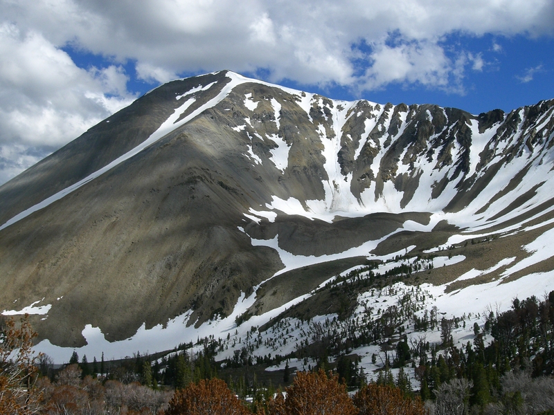
Redbird Mountain is the highest point in the White Knob Mountains, which is home to five of Idaho’s 11ers. It can be climbed from either Burma Road (to its west) or Alder Creek Road (to its east). Redbird Mountain is often climbed in combination with other 11ers on the White Knob Crest. USGS Shelly Mountain
Redbird Mountain. Matt Durrant Photo
Northwest Ridge and South Ridge Routes by Livingston Douglas
Access
Same as for Cabin Mountain. This is the third leg in a 4-peak adventure that includes Cabin Mountain (11,244 feet), Lime Mountain (11,179 feet), Redbird Mountain, and Shelly Mountain (11,278 feet). It covers 16.5 miles with 5,150 feet of elevation gain round trip. The Cabin Mountain access information is as follows.
From its junction with FSR-138/Copper Basin Loop Road, drive east then north on FSR-142/Burma Road for 0.4 miles. You will cross both the East Fork Big Lost River and Cabin Creek on the way. Continue to a junction with an unmarked 2-track jeep road that follows the north side of Cabin Creek. Park at this junction (7,740 feet) since the 2-track road is very rough and is not drivable.
Please note that the shorter route to Redbird Mountain is via its east side from Alder Creek Road (see Page 264 of the book). From Alder Creek Road, you can either climb the narrow, rugged east ridge (Class 2-3) or the east gully then south ridge (Class 2). If the gully bushwhack is tolerable, I would prefer the latter route as it is the most direct route to the summit and presents no ridge difficulties.
Northwest Ridge, Class 2
The Climb
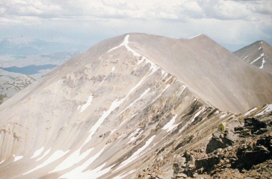
From the 10,700-foot connecting saddle with Lime Mountain, scramble southeast up the narrow ridge. Work around a series of easy ridge outcrops using goat trails to approach Point 11249. Skirt the right/west side of Point 11249 to reach a high ridge saddle at 11,180 feet. Continue south up the ridge crest for a short distance to the cairned summit of Redbird Mountain. The summit had a decent cairn but it needed some help. I enlarged it significantly for the benefit of future climbers. The northwest ridge is a mix of short scrub, broken rock, and minor rocky outcrops. It presents no problems.
South Ridge, Class 2
The Descent
From the summit, descend the easy, open south ridge on broken rock to reach the narrow, elongated connecting saddle with Shelly Mountain. This saddle is at 10,620 feet. This concludes the third leg of today’s 4-peak journey. Shelly Mountain (11,278 feet) is up next.
East Ridge Route by Ken Jones
Access
Mackay Approach. From the junction of Main Street and US-93 in Mackay, drive 2.4 miles south on US-93 to a signed junction with Houston Road. Turn right/south onto Houston Road and drive 2.0 miles to an unsigned junction with Alder Creek Road. Turn right/south onto Alder Creek Road and drive 1.6 miles to an unsigned junction at a private ranch and a sharp right/southwest turn in the road. Reset your odometer here. From the unsigned junction, drive southwest on Alder Creek Road.
At 2.9 miles, reach the Challis National Forest boundary. At 7.7 miles, reach a signed junction. Go left. At 8.5 miles reach a crossroads – go left onto FR 516, which is 4WD/high clearance. At about 8680′ elevation, the road is posted as closed to vehicles over 50 inches wide.
Arco/Darlington Approach. The east side approach to Redbird Mountain is via the Alder Creek Road and Sawmill Canyon. Follow US-93 north from Arco until you reach the microscopic community of Darlington. Turn left on Smith Road and follow it toward the hills to the west. Eventually it turns to the north and becomes Dove Road. Stay to the left/west at any road forks/junctions.
Just past a remote ranch house, Dove Road turns into Alder Creek Road and enters the Challis National Forest. From here, the road gets worse until it deteriorates to an ATV track leading to the 10,000-foot summit at the head of Stewart Canyon. Before the road reaches the intersection where it becomes the ATV track, find a signed turnoff for Sawmill Canyon. This road is narrow, steep, and rough. Park soon after you turn off and follow the road on foot.
East Ridge, Class 2+
From the parking area follow the mapped jeep to just under 9200 feet. From this point follow the mining road southeast up to the top of the east ridge. The route continues has shown on the GPS track set out below. We found the ridge reached by the jeep road easier down low, and the east ridge of Redbird Mountain proper easier up high. They can be connected by a traverse between the two at around 10,400 feet.
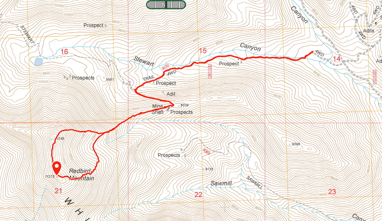
Karen Jones GPS track covers 6.0 miles with 2,870 feet of elevation gain.
Redbird Mountain
Additional Resources
Regions: EASTERN IDAHO->White Knob Mountains
Mountain Range: White Knob Mountains