Article Index
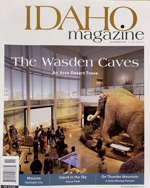
This article originally appeared in the Idaho Magazine’s November 2021 issue. VOL. 21, NO. 2
 I first became aware of Grave Peak when I read USFS 1919: The Ranger, the Cook, and a Hole in the Sky, by Norman Maclean published in his 1976 book A River Runs Through It and Other Stories. Maclean’s book often referred to as a semi-autobiographical novel feels more like a memoir than fiction. It is both poetic and operatic as it tells the story of his experiences in 1919 working for the Forest Service when he was 17 years old. Maclean starts this saga writing “I was young and I thought I was tough and I knew it was beautiful and I was a little bit crazy but hadn’t noticed it yet. Outside the ranger station there were more mountains in all directions than I was ever to see again—oceans of mountains . . ..” Two sentences and I was hooked.
The setting for the story was the Elk Summit Guard Station, an exceedingly remote location of Idaho’s Clearwater Mountains. Unlike today, Elk Summit was only accessible by a 28 mile long, difficult trail from the opening of Blodgett Canyon near Hamilton, Montana.
Grave Peak
Like all good memoirs this story not only relates interesting history but also puts us in Maclean’s life, mind and soul. We learn about those early days when the young Maclean was older than the recently created Forest Service and when wild country was truly—wild country. Maclean’s story sets a baseline against which we today can measure both the present state of the environment and ourselves.
I never doubted that a hundred years ago life and people were much tougher, more resilient and capable than my generation. Times were certainly tougher than when I worked for the Forest Service at the end of the 1970s. The story provides glimpses of fighting forest fires, building trails, stringing telephone wire through dense forests to mountain tops with the only non human power supplied by skittish horses and cantankerous mules. More importantly from my perspective Maclean’s tome related the remoteness and beauty of the pristine land in which the story unfolds with a vividness that made my life feel at once insignificant and at the same time full of possibilities.
In the story after complaining to the ranger about the Guard Station’s cook his boss, the ranger, exiled Maclean to Grave Peak to replace a fire lookout who had suddenly quit. Maclean, angry at his inability to “keep his mouth shut” left the Guard Station and made the journey to the towering peak in one long push. His description of time spent camping in a meadow below the peak, dodging a grizzly bear that frequented the area and sitting on the then structureless mountain summit for hours searching the vast view for fires captivated me. His story encapsulated my young man’s desire to both escape the trials and tribulations of every day life and to confront the unknown.
Reading this story was the first time Grave Peak came into my consciousness. Nevertheless at that point in my life Grave Peak was simply a mythical destination. As time and I became more addicted to the mountains Grave Peak transformed into a must visit destination. Although this destination long weighed on my mind forty five years would pass between reading Maclean’s story and my arrival at the trailhead.
Although over a hundred years have passed since Norman Maclean scanned for forest fires from its exposed summit, Grave Peak is still remote and difficult to reach. It is now part of the Selway Bitterroot Wilderness Area. It is a place that many will wonder about but few will visit.
The United States Congress designated the Selway-Bitterroot Wilderness in 1964. It is the third largest Wilderness in the Lower 48. This immense triangle-shaped wilderness encompasses over 2,100 square miles most of which are in Idaho. It is the third largest designated wilderness in the lower 48 states. US-12 and the Lochsa River border the wilderness on its northern side and the Magruder Corridor forms it’s southern border.
The Idaho portion of the wilderness is characterized by forested ridges and winding, deep canyons which are occasionally pierced by high, isolated mountain peaks. Maclean called the Grave Peak area the “Hole in the Sky.” To me Grave Peak is an Island in the Sky.
The lower ridges and canyons are home to thick coniferous forest at their higher elevations and filled with old-growth cedar, fir, spruce and pine at the lower elevations. In Maclean’s time only a few people had traveled this difficult country. Today, even though there are nearly 1,800 miles of trails crisscrossing the wilderness few people visit it’s remotest areas. Those that do visit congregate mostly along the periphery or float the Selway River, one of America’s premier whitewater rivers, which slices through the heart of wilderness. It is far and away the home of elk, deer, moose, black bears, (the occasional) grizzly bear, mountain lions and wolves rather than man.
Grave Peak acquired its somewhat morbid name after Isaac Hill, a miner, was buried by Jerry Johnson between Tom Beall Park and its summit in 1892. Besides it’s supporting role in Maclean’s memoir, Grave Peak has two other claims to fame both related to its physical attributes—shape and prominence.
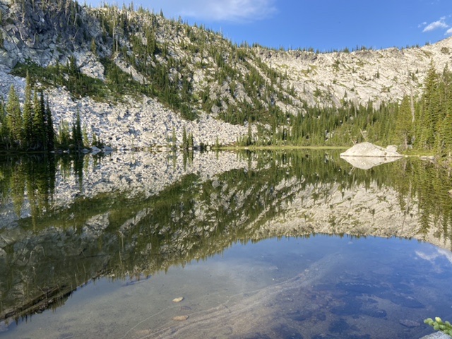
Physically the mountain is composed of nearly impregnable granite carved by glaciers into a formidable three-sided pyramid that reaches skyward topping off at 8,282 feet. It’s three glacially-carved faces stand over impressive cirques. Ranging from fifteen hundred to two thousand feet below the summit ten pristine high mountain lakes and numerous ponds ring the peak sparkling like a jeweled necklace.
Grave Peak rises over 2,500 feet above its surroundings making it the most prominent mountain for many miles. Not only does it’s dominating height provide views from its summit that stretch from the imposing Bitterroot Mountains divide in the east to the Buffalo Hump in the Gospel Hump Wilderness in the west and from the Salmon River Mountains in the south to northern Idaho giants like Illinois Peak on the Idaho Montana border.
It’s commanding height led the United States Forest Service to start using it as a fire lookout after the tragedy of the 1910 Big Burn. The Big Burn, a precursor of the fires now devastating central Idaho, actually encompassed nearly two thousand fires, many which merged burned three million acres burned in Idaho and Montana, killed 85 people and destroyed several small towns.
Early on in its history the Forest Service had instigated a fire suppression policy of extinguishing all fires. The Big Burn lead to a doubling down on this policy. The goal was to completely defeat wildfire. In support of this policy the agency worked with state and private associations to expand the use of fire lookouts. Until Smokey the Bear became the face of the Forest Service in 1944 the lonely fire lookout, perched on a mountain top, was emblematic of fire fighting policy.
Lookout sites sprouted like dandelions in your neighbor’s yard. Between the Lochsa River in the north and the Salmon River in the south and US-95 in the west and the Idaho/Montana border in the east at least 202 mountains were used at one time or another as fire lookout sites.
Thus, in a time before aerial surveillance and radio communications fire lookouts served as the early warning system. A system that would constantly evolve over the years. The next step in forest fire fighting was the installation of telephone lines to the tops of many mountains that like Grave Peak proved good vantage points.
In Maclean’s time the lookouts camped near a mountain’s summit during fire season. During the day they would climb to the top and look for fires. They were no buildings on peak. If they spotted a fire they would turn the hand crank on their phones, report the fire and then transition from a lookout to “smokechaser.” Smokechasers were the equivalent of today’s first responders who after discovering would travel to the fire and attempt to extinguish it.
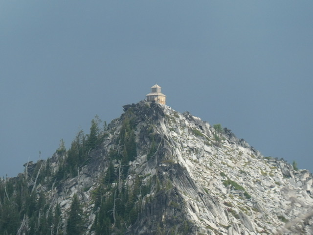
In the 1920s the Forest Service started to build lookout structures to house their personnel. The Grave Peak copola was built in 1924. It is one of the most unique lookout structures in Idaho and is listed on the National Historic Lookout Register.
In September 25, 1922 The Daily Missoulian reported that “During the summer a lookout house was built on the top of Grave peak at an altitude of 8,287 feet. The material was all transported 50 miles by horse and three-quarters of a mile on the backs of the rangers. To hold the building secure against storms, bolts were sunk into the bedrock and guy wires tied in from the cupola to safe anchorage on solid rock. Many miles of trail cutting was also done which will enable the rangers to cover the district in much less time than formerly.”
As time passed the Forest Service developed “visibility maps” which detailed the area that could be viewed from a summit. Before the maps were developed early lookouts were haphazardly placed in many locations that could vary from year to year. As the maps were completed placement of lookouts was more systematic and only peaks with the biggest views survived as lookout locations. A peak’s prominence was often a hinderance rather than an asset for finding fires because the peak’s views were often blocked by low lying haze. It’s not clear if Grave Peak was a casualty of the visibility studies or it’s remoteness or airplane surveillance but it is clear that the lookout was abandoned in 1967 by the Forest Service.
Peakbaggers are a difficult group to define. Whilst in general they are climbers who seek to climb a group of summits categorized or listed by location or height or some other source of significance, the underlying motivation for their efforts is unclear. When you ask peakbaggers why they climb you will get all sorts of answers ranging from George Mallory’s simple answer when asked why he was trying to climb Mount Everest in the 1920s, of “because it’s there,” to “I don’t know” and every possible iteration in between those two extremes. One group of peakbaggers, and it’s a big group, focus their energies on visiting current and former fire lookout sites. While not an exclusive motivation, I find a peak’s history as a lookout site as good a reason as any to climb a peak.
In this case, my desire to climb Grave Peak was to experience some semblance of what Norman Maclean experienced a hundred years or so earlier. My fellow Peakbaggers Alex Feldman and Steve Grantham came along at my invitation evidently to see what the mountain had to offer their sense of adventure. Peakbagging is not without its cost. To reach the trailhead we drove for nine hours passing through Horseshoe Bend, Cascade, Donnelly, McCall, New Meadows, Grangeville, Harpster, Stites and Kooskia. From Kooskia we made the long drive up US-12 along the Clearwater and then Lochsa Rivers. The temperature hovered around 99 degrees most of the way.
Just past Powell Junction our route left the pavement. We took the relatively good but narrow and steep Forest Service Roads toward Elk Summit. All the while we wondered if the last couple of miles on the side road to the Kooskooskia Meadows trailhead would be passable. The side road was signed and carried a warning that the road passed through a burned area. As the climate has warmed over the last hundred years massive sections of central Idaho have burned. The burns have left literally millions of standing burned trees. These tottering remnants of once great forests are liable to fall at any minute. A wind storm or even a slight breeze my make a passable road a nightmare in no time at all.
We drove up this road that was steep and rutted in places. And yes, there were a lot of downed trees. Fortunately, the downfall was cut out. The narrow passageway through the sawed trees required some delicate maneuvering but we arrived at roads end. The trailhead was a small, claustrophobic clearing in a partially burned forest. The temperature was 80 degrees. Biting black flies and mosquitoes hovered around us disturbing the other wise dead still and quiet that greeted us.
The forecast for the next day was not ideal as it included a chance of thunderstorms after Noon and windy conditions. Thunderstorms could keep us from reaching the exposed the summit. The wind could knock down the dead trees standing along our line of retreat. Yes, we had two saws for such emergencies. No, the idea of cutting our way out was not appealing. An early start was essential.
At 4:00am I heard Steve moving around camp. Soon, all three of us, and the mosquitoes, were up. We quickly snacked, checked our packs and bemoaned the mosquitoes. At ten minutes after five in the morning, as the sky lightened we were on the trail. A short ascent along a closed road, blocked in places by downfall, lead to a nearly mile long descent to Lake 6130 and the beginning of the Friday Pass Trail.
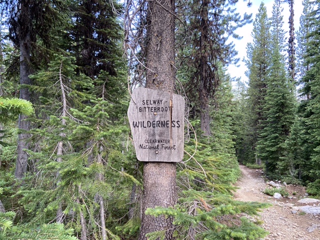
The wilderness boundary was a short distance beyond the trailhead.
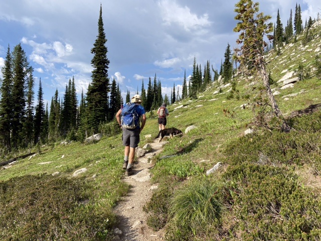
The trail now dropped a short distance to Kooskooskia Meadows before beginning climbing relentlessly toward Friday Pass. Good pacing is what makes climbing easy. Going too fast will cause you to go anaerobic. When your body runs low on oxygen you tend to stop frequently to catch your breath. If you manage your walking pace correctly you can just keep going. Alex, Steve and I took turns setting a reasonable pace and even though the trail’s tread was overgrown in places and the route was frequently interrupted by downfall.
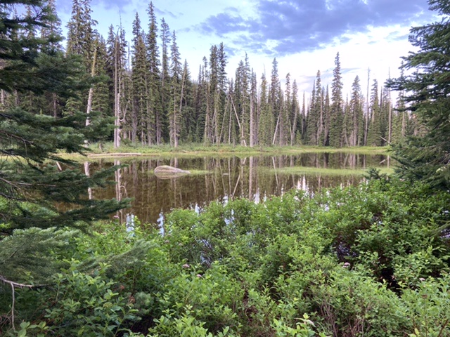
The first lake in the still of the morning.
We reached Swamp Lake. Steve pointed out the lake’s name was consistent with Idaho naming protocols. In other words, the lake was misnamed. There was nothing “swampy” about the lake. Swamp Lake sits at the interface between the northern forest and alpine terrain above. It is a beautiful spot where one might be tempted to sit and enjoy the blossoming morning. Cognizant of the 30 percent chance of thunderstorms we resisted the temptation and continued on as the trail climbed up the headwall, switchbacking toward the pass still another 900 feet of elevation above us.
Swamp Lake
As we neared the pass, Alex said “that’s thunder.” No, I thought, “it’s too early.” I looked at the sky. An edge of darkness met the morning’s bright sunshine on a line punctuated by the ridgeline. The thought that long drive and the swampy mosquito infested night might have been in vain entered my mind. You just cannot safely cross exposed ridges when lightning threatens. Nevertheless, we had no intention of turning around. After a short discussion, we decided to continue to the partially forested Friday Pass.
Climbing the headwall to Friday Pass.
As we reached the pass we were confident that the storm was simply an isolated cell that would soon pass. However, a strong gust of cold wind, a flash of light and an almost immediate loud boom sent is scurrying down the west side of the pass seeking safer terrain. The trail drops off the west side of Friday Ridge into a stunted forested interspersed by nearly vertical meadows and granite slabs. We stopped at the edge of a steep meadow and a large snowfield.
The sky was dark as the lightning and thunder picked up. I put on my rain jacket and pants convinced that we were in for heavy rain and a long wait. The mountain gods watching our preparations evidently decided enough was enough, the storm cell suddenly moved off of Grave Peak and Friday Ridge and disappeared to the east. “Thanks for putting all that rain gear on,” Alex quipped, implying my preparation was responsible for the thunderstorm’s sudden departure.
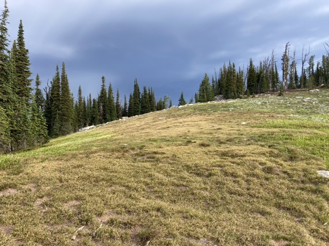
Storm clouds over Friday Pass.
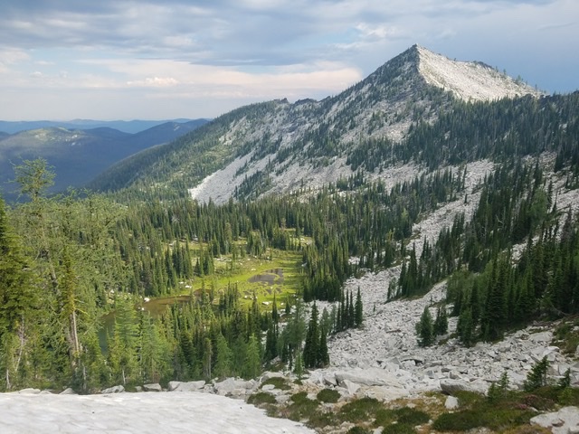
Grave Peak viewed from Friday Pass.
We packed up, crossed the snowfield and followed the trail north as it traversed the side of Friday Ridge toward the base of Grave Peak. The trail crosses back to the east side of Friday Ridge at the base of Grave Peak’s south ridge. The forest fizzles out at this point. Above us stretched a land of steep granite. The trail now switchbacks up the bare east side of the ridge. Suddenly, my legs felt like lead and my impeccable pacing was lost. Alex and Steve climbed ahead strongly while I bogged down.
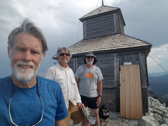
Steve, Tom and Alex.
Finally, I reached the top. The trail ended ten feet below the lookout which sits squarely on the summit stretching from the abyss on its west side to the abyss on its east side. “How did they build this thing,” I thought when I finally pulled myself to the top.
The 360 degree view is unimpeded for miles. There was no question why this spot was picked for a lookout. The surrounding lower ridges appear to lap up to the base of Grave Peak like waves crashing on the shores of an island—hence, Grave Peak is a proverbial Island in the Sky.”
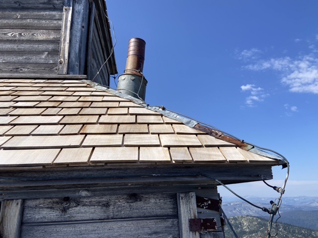
The Grave Peak lookout is occasionally maintained by volunteers.
Although still wild, the country is not nearly as wild as it was in Maclean’s time. Grizzly bears, like the one that occasionally drove Maclean to climb a tree are seldom seen. The shortest route to the summit is miles shorter and starts at a much higher elevation. The environment that Maclean confronted has changed significantly in the last one hundred years. It is still an amazing ecosystem. I wonder how long it will last. We climbed the peak on a Wednesday. The next day the sky was filled with smoke from a nearby, out-of-control, forest fire. By the following weekend 70 major fires were burning across the West.
Next: The High Point of the Wallowas