Elevation: 10,744 ft
Prominence: 604
Climbing and access information for this peak is on Page 297 of the book.
Wright Peak is located on the main Lemhi Range Crest south of Buck Lakes Peak. The unofficial name is derived from the peak’s location above Wright Lakes. Rick Baugher climbed this peak in 2000 and found no evidence of previous ascent. More recently, Livingston Douglas provided two new routes described below. USGS Lem Peak
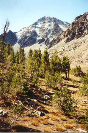
Wright Peak as viewed from the southwest from 9,400 feet, just above the northernmost Wright Creek Lake (10/4/00). Rick Baugher Photo
Northwest Ridge, Class 2 by Livingston Douglas
Access
This climb is the last leg of a ridge traverse from Lem Peak to Buck Lakes Peak to Peak 10744.
The Climb
From the 10,140-foot saddle between Buck Lakes Peak and Wright Peak, climb the easy Class 2 Southeast Ridge up to 10,500 feet. Then turn slightly R/SSE to skirt below the [lower] double-humped Northwest Summit. Continue to a gentle saddle at 10,500 feet and then along the ridge to the true summit, which is located at the Southeast End of the summit massif.
Buck Creek Basin (Descent), Class 2+ by Livingston Douglas
The Descent
From the summit, descend to the 10,140-foot saddle between Peak 10775 and Peak 10744. Skirt to the right of snowdrifts on the northeast side of the saddle, as well as to the right of the high-basin snowfields. Descend to the right of prominent cliff bands that accentuate the center of the top of this basin. Once you’ve reached the flatter terrain (and tree line) in the basin itself, stay well to the right side of the drainage, so you can follow Buck Creek northward.
The bushwhack along the right side of Buck Creek goes quickly down to just below 9,000 feet. Starting here, hiking is going to get a bit more difficult, as a lot of downed timber exists. Your goal is to intercept the good trail that climbs up to Buck Lakes 8474 on the south side of the outlet stream from that lake.
Once you reach about 8,600 feet, cross to the left side of Buck Creek. Move away from the creek a bit, so that you can intercept the trail more easily. Just as I was becoming tired and frustrated from the moderately-difficult bushwhack through the now-flatter forest, I stumbled onto the blessed trail, which is well-beaten and impossible to miss.
The trail is important to find because it crosses the outlet stream on a small footbridge and avoids the torrent that is now Buck Creek. Follow the trail to the footbridge across Bear Valley Creek and re-join the main trail. Descend the Bear Valley Lakes trail back to the trailhead.
Additional Resources
Regions: EASTERN IDAHO->Lemhi Range
Mountain Range: Lemhi Range
First Ascent Information:
- Other First Ascent: Northwest Ridge
- Year: 2017
- Season: Summer
- Party: Livingston Douglas
- Other First Ascent: Northeast Ridge—Descent
- Year: 2011
- Season: Summer
- Party: Michael Darcy
- Other First Ascent: Buck Creek Basin-Descent
- Year: 2017
- Season: Summer
- Party: Livingston Douglas
Longitude: -113.84179 Latitude: 44.75629