Elevation: 6,220 ft
Prominence: 440
This peak is not in the book. Published April 2018
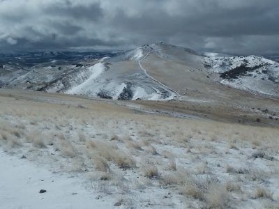
This peak is located southeast of Squaw Butte. Although a 4WD road leads close to its summit, it would be difficult to do this one as a drive-up since the road conditions are quite rough. USGS Rooster Comb Peak
Access
To reach this peak, follow Wilson Creek Road to the crossing of Salmon Creek. Cross Salmon Creek and turn south onto an unnamed road. Follow this road until you reach Murphy Creek and turn right. Follow this road until you reach a weather station. Park here.
Route
If you think you can get up the steep hill to the south, cross Murphy Creek and drive up the hill to gain the ridge. Follow the road west until it ends. From there, hike west for less than a mile and take this road uphill until it intersects with another road. Turn south and follow the road for about a mile. This road nearly leads to the summit. The summit views are excellent of the Silver City Range and the northern Owyhees Mountains. A 4WD vehicle is required unless you plan on a lengthy hike/run like I did. Coal Bank Peak is a nearby unranked summit that looked interesting (could easily be combined with 6220) but I did not do it since I parked at Salmon Creek.
Additional Resources
Regions: Owyhee Mountains->SOUTHERN IDAHO
Mountain Range: Owyhee Mountains
Longitude: -116.8535 Latitude: 43.2312