Elevation: 7,321 ft
Prominence: 301
This peak is not in the book. Livingston Douglas climbed the peak via a different route. His entry and photos is found down the page. Updated January 2023
This peak is the northernmost Sublett Range peak that exceeds 7,000 feet. The view from its summit extends all the way across the Snake River Plain to the Pioneer Mountains, the Lost River Range, and the southern Lemhi Range. The name was suggested by Rick Baugher and is based on a rock carving made by Neilsen and Scott in 1898. Rick found the rock on the peak’s slopes (see the photo below). USGS Hartley Peak
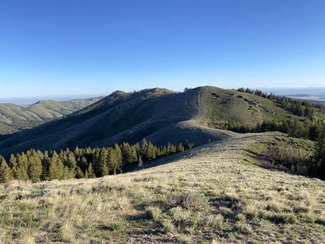
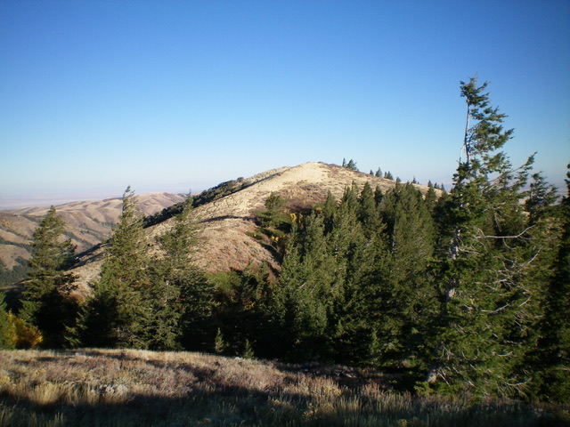
The high point is just left of center in this photo
Access
This peak can be accessed from the east and ID-34 via Flint Canyon or Hartley Canyon and from the west via Sheep Canyon. I have not driven the east-side roads and will focus on the western access. Please note that Google Maps provides good directions to most points in the Sawtooth National Forest portion of the Sublett Range.
From the east, access the peak from North Heglar Canyon/South Summit Canyon Road/FSR-565. This road is the primary north/south route through the Sublett Range. Both ends of this road are accessed from I-84. To reach the road from the north, leave the freeway at Exit 228. Head east on East Yale Road for 8.7 miles and then turn onto the North Heglar Canyon Road. This road becomes FSR-565 when it reaches the National Forest Boundary. The southern approach leaves I-84 at Exit 245. From the freeway, turn east and follow the road east/southeast into the mountains for 11.0 miles to Sublett Reservoir. This road also becomes FSR-565 when it reaches the National Forest Boundary. Follow FSR-565 to Sheep Canyon Road.
If you are coming from the north, Sheep Canyon Road/FSR-579 is reached at a signed junction 0.2 miles south of the Mill Flat Campground. If you are coming from the south, the road is reached 11.6 miles past the junction of FSR-565 and FSR-564 on the north side of Sublett Reservoir. Please note that although the Forest Service signs this road as Sheep Canyon Road, Google Maps calls it Hartley Summit Road. Turn east onto Sheep Canyon Road and follow it 3.2 miles to the pass on the crest and a 3-way junction. Park here.
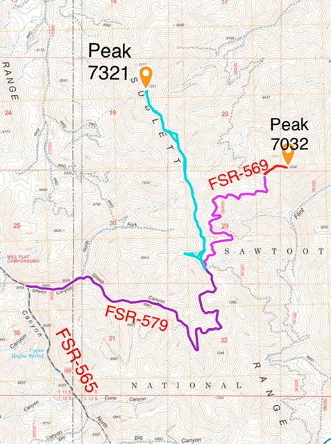
Access via Sheep Canyon is shown in purple and to Peak 7032 in pink.
South Ridge, Class 2
This route is a pleasant, rolling ridge walk. An ATV trail follows the ridge north from the pass. Follow this track on its up-and-down journey north. When the ATV trail ends, continue north on the ridge crest. You quickly reach an ancient bulldozer cut fire break. Follow this overgrown fire break north. It is amazing how steeply the bulldozer climbed up the steeper sections of the ridge. The ridge is brush-free except for one small section in the last saddle before the summit. The round trip covers 3.8 miles with 439 feet of elevation gain.
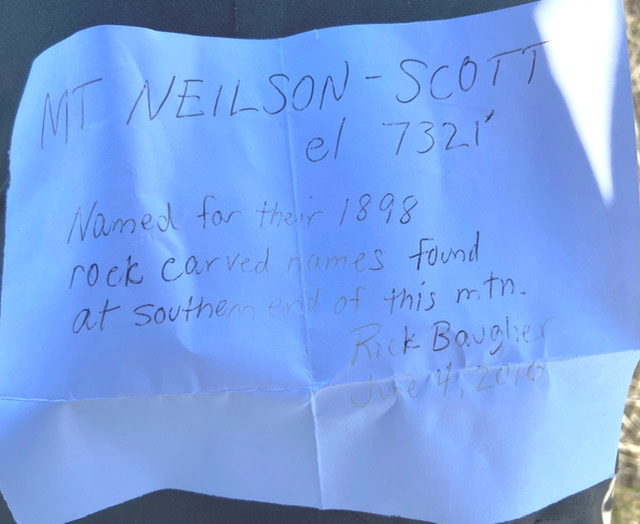
Rick Baugher’s note in the summit register
Southwest Spur/South Ridge and South Ridge/East Gully Routes by Livingston Douglas
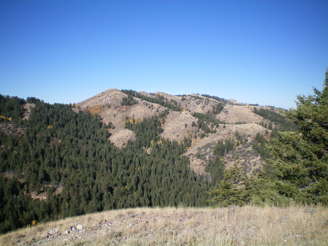
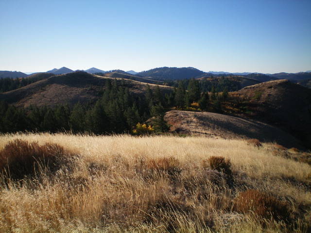
Peak 7321 (the lumpy ridge crest in the distance) as viewed from Peak 7032 to its southeast. Livingston Douglas Photo
Access
From the junction of North Heglar Canyon Road/FSR-565 and [signed] Sheep Canyon Road/FSR-579, drive east on FSR-579 for 0.5 miles to a road junction in a meadow. Go left/north here onto FSR-577 (signed for “Holtz Canyon”) and drive 0.6 miles north then northeast then east to a sharp left turn in the road at a gully with an old 2-track heading straight/east. Park at this bend in the road (6,425 feet). GPS coordinates: 42⁰26’11”N, 112⁰59’33”W.
Southwest Spur/South Ridge, Class 2
The Climb
From the road bend, follow a weak use trail north up onto the southwest spur through a short patch of forest. Once on the open ridge crest, follow a game/use trail northeast up the easy scrub to reach a junction with the south ridge at about 7,240 feet. While the game/use trail flames out before reaching the south ridge, the short scrub is an easy scramble. Once on the south ridge, find an old 2-track road coming up from the south along the ridge crest. Follow this 2-track north along the ridge until it soon ends. Descend north on ridge on easy scrub to reach a ridge saddle at 7,060 feet. The old road disappears before you reach the saddle.
This saddle is at the head of the east gully, which is a critical component of the descent route (to be discussed) so you will return here after reaching the summit of Peak 7321. From the saddle, follow a use trail (probably used primarily by hunters) along the ridge crest. The ridge meanders and has plenty of frustrating ups and downs on its way to the elusive summit hump of Peak 7321. The use trail ends before the final push to the summit. The summit had a modest cairn which I doubled in size. The final false summit hump is awfully close in elevation to the official summit.
The elusive summit hump of Peak 7321 as viewed from high on the south ridge. Livingston Douglas Photo
View of the undulating, weaving south ridge from the summit of Peak 7321. The ridge moves from right of center to left of center in the photo. Livingston Douglas Photo
South Ridge/East Gully, Class 2
The Descent
From the summit, return south on the undulating, weaving ridge back down to the aforementioned 7,060-foot saddle at the head of the east gully. Descend east on the left/north side of the gully in open terrain. Move into the forested center of the gully (or near it) to avoid difficult side-hilling in the steeply-angled scrub. The forest bushwhack down the dry gully isn’t too bad but it does have some areas of blowdown and aspens to work around. Reach FSR-569 at the base of the gully. Follow FSR-569 (a narrow but decent road) as it winds its way southeast up to a saddle at 6,700 feet, about 150 vertical feet higher than the entry point at the base of the east gully of Peak 7321. This saddle sits at the base of Peak 7032, the next objective in today’s 2-peak adventure.
Additional Resources
Regions: SOUTHERN IDAHO->Sublett Range
Mountain Range: Sublett Range
Year Climbed: 2021
Longitude: -112.98889 Latitude: 42.45409