Elevation: 9,380 ft
Prominence: 280
This peak is not found in the book. Livingston Douglas added the 2024 Update which includes more detail than my 2014 entry. Updated December 2024
Peak 9380 sits between Estes Mountain and Mount Greylock, north of the Yankee Fork Town Site. It is 1.2 miles SSE of Estes Mountain and 0.8 miles north of Mount Greylock. I climbed the peak in 2014 with Gilbert Gallegos and Andrew Chiles from the saddle south of Estes Mountain. The summit is 1.4 miles south of the parking spot described below (as the wolf walks) with an elevation gain that will vary depending upon whether you cross over or skirt Peak 9366. Access to the ridge is set out below. Class 2. USGS Custer
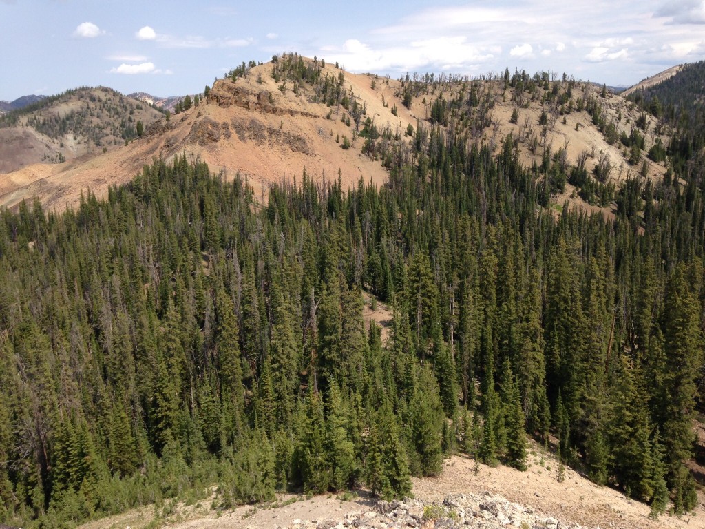
Peak 9380 as viewed from Peak 9366. Mount Greylock rises in the upper right corner.
The following access information expands on the access information in the book. Start on Loon Creek Summit Road [(F)(3.2) on Page 141], which begins just north of the Yankee Fork Dredge. From this road, you can access the ridge between Estes Mountain and Mount Greylock via a road that, as far as I know, does not have a Forest Service number designation. I will designate it as FS-3.2.2, Estes Mining Road. This road leaves Loon Creek Summit Road 5.1 miles north of the beginning of that road. The Forest Service map and the USGS quad show this road as a jeep trail but it is a well-maintained (albeit steep) road that leads up and over the ridge to the east. Turn right onto this road and drive 3.4 miles to the ridge top, where you will find parking and a spot to make a pleasant, dry car camp.
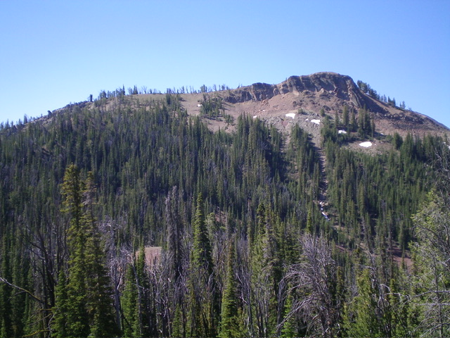
Peak 9380 as viewed from Mount Greylock.
2024 Updates by Livingston Douglas
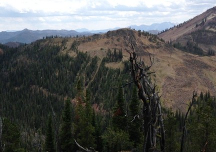
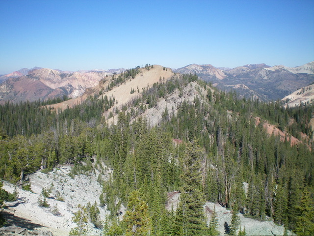
Peak 9380 as viewed from Peak 9366 to its north. The north ridge (my first ascent route) is left of center. The east ridge (my second ascent route) is the skyline in center and left of center. The summit is well right of center on the high ridgeline. Livingston Douglas Photo
Peak 9380 is a soft-ranked summit on the lengthy north ridge of Mount Greylock (9,857 feet). It has an unusual, elongated east-west ridge crest summit area. The high point is at the west end of this ridge crest area. Peak 9380 is often climbed in combination with Mount Greylock to its south.
Access
Same as for Peak 9366. This is the second leg of a 4-peak adventure that includes Peak 9366, Peak 9380, Mount Greylock (9,857 feet), and Peak 9403. It covers 7.0 miles with 3,150 feet of elevation gain round trip.
North Ridge, Class 2+
The Climb
From the 8,820-foot connecting saddle with Peak 9366, bushwhack southeast up out of the thick, blowdown-laden saddle onto the forested north ridge of Peak 9380. Aim to reach the high summit ridge well left/east of the high point. There is an impassable cliff band on the north side of the high point that must be avoided. Stay in forested terrain to have any traction. Higher up, grab onto young pines to advance up the steep, loose gravel (Class 2+). Upon reaching the summit ridge, head right/west through a few easy, rocky ridge outcrops to reach the gentle, gravelly high point at the far west end of the ridge crest. There was no summit cairn so I built a small one on the high point.
Peak 9380 and its rocky south ridge as viewed from Mount Greylock to its south. The south ridge was my descent route on the way to Mount Greylock. Livingston Douglas Photo
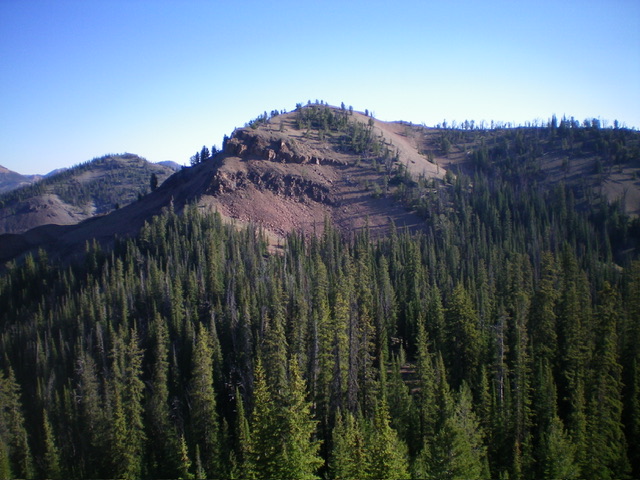
Peak 9380 (dead center) and its rocky east ridge (in center and right of center) as viewed from Peak 9403 to its east. The east ridge was one of my ascent routes. Livingston Douglas Photo
South Ridge, Class 2
The Descent
From the summit, descend south-southwest then south in open, rocky/gravelly terrain. You will soon encounter a massive cliff band that cannot be downclimbed. Skirt it widely to its right or left and descend steep, loose scree/gravel. Angle back over to the ridge crest (tedious). I descended just right of the cliff band, which is probably a little better at getting you back to the forested ridge crest lower down and still above the saddle area. Descend south through the pine forest to reach the elusive connecting saddle with Mount Greylock. This concludes the second leg of today’s 4-peak journey. Mount Greylock (9,857 feet) is up next.
East Ridge, Class 2
The Climb
From the 9,100-foot connecting saddle with Peak 9403, bushwhack across the thickly-forested, narrow ridge saddle to reach the base of the east ridge of Peak 9380. Scramble northwest then west on open rock up through easy, rocky ridge outcrops that look intimidating from a distance. Higher up, skirt the left/south side of a series of ridge outcrops (or climb directly up over them) to reach the high point of Peak 9380 at the west end of the high ridge crest.
Additional Resources
Regions: Eastern Salmon River Mountains->Salmon River Mountains->Southeast Corner Peaks->WESTERN IDAHO
Mountain Range: Salmon River Mountains
Year Climbed: 2014
Longitude: -114.69469 Latitude: 44.43149