Elevation: 5,732 ft
Prominence: 392
This peak is not in the book. Updated April 2018
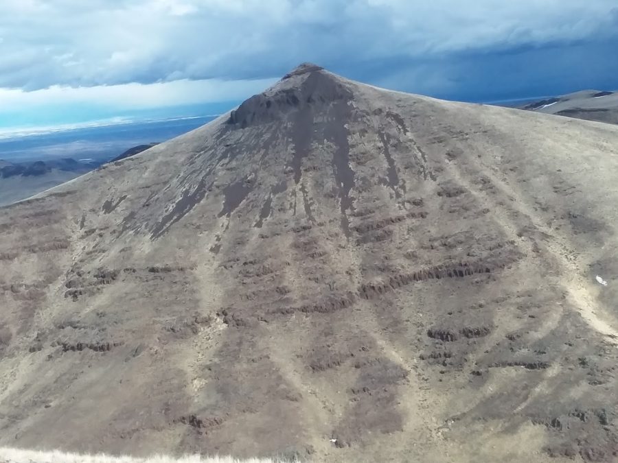
Dryden Peak is located in the Western Owyhee Mountains north of Piute Butte and due south of Buck Mountain. The ridge it sits on is the second north-south ridge line east of US-95. This peak has an interesting cone-shaped, cliff-ringed summit. USGS Soldier Cap
Squaw Creek and its tributaries cut deep canyons on the Dryden Peak’s west, south, and southeast sides. Rodeo Gulch is on the peak’s north and west slopes. An east-trending ridge runs from Dryden’s West Face to a pass and then east to another high ridge system.
Private property makes the most direct access via Squaw Creek problematic. Private property is also an issue, albeit one with a solution, when approaching the peak from the northeast. Nevertheless, from any direction, intervening private property makes access to the summit a bit convoluted.
Brett Sergenian avoided all private property issues by climbing the peak from US-95. His approach involves a long up-and-down hike over the high ridge, which blocks the peak’s direct access, and then descends into Squaw Creek before starting the actual climb to the summit. As a result of the necessity of climbing over and then descending the ridge line between US-95 and Squaw Creek, this route demands 2,000 feet of elevation gain just to reach the top. And, of course, you also must re-climb the intervening ridge on the way out. This route is not recommended for mere mortals. We have included this information only for historical purposes. The recommended route is set out below.
Dryden Peak. Brett Sergenian Photo
Access From the North
Coyote Grade Road. Take ID-78 east from Marsing, Idaho for 5.5 miles. Turn right/south onto Clark Road. Follow this road for 3 miles (the first 2 miles of the road are paved) to a signed junction. Unfortunately, the junction does not have a sign that identifies this road as the Coyote Grade Road. Google Maps will also get you to Coyote Grade Road.
At the junction, turn right onto Coyote Grade Road and head toward the signed Rat’s Nest Area. The name probably refers to the maze of roads that you will quickly encounter. Follow the road that obviously gets periodic grading as it wanders uphill. After 5 miles and 1,500 feet of elevation gain, you cannot miss Shares Snout towering above you on the south side of the road. The road to this point has a few sharp turns and a couple of impressive dips but is periodically maintained and, when dry, is passable for 2WD vehicles with adequate clearance. However, the road deteriorates beyond Shares Snout. To continue farther, you need a high-clearance vehicle with good all-terrain tires.
Continue up the road and cross a pass northwest of Shares Snout. Stay on the main road and drop down to the southwest. Ignore the first left turn and continue your descent to the second left turn. This road is a seldom-used two-track that runs due north. Although there a few rocky spots, it is not deeply rutted. At the 4,600-foot contour, the road forks. Take the right fork and you will soon reach a fence line that marks the boundary between BLM land and private property. From this point, the road drops down into Rodeo Gulch.
The road across private property and into Rodeo Gulch is not posted with “No Trespassing” signs or orange paint. I believe that BLM has secured an easement for the road across this property and into the gulch since there is a BLM-constructed pipeline running out of the gulch to fill cattle troughs on the BLM land. This access to Rodeo Gulch may be posted in the future. If it is posted, please park at the gate. Always respect private land. The route information below provides a work-around that will let you hike to Rodeo Gulch and while avoiding the private land. The driving distance from the Clark Road/Coyote Grade Road junction to this point is 9.5 miles with 2,300 feet of elevation gain.
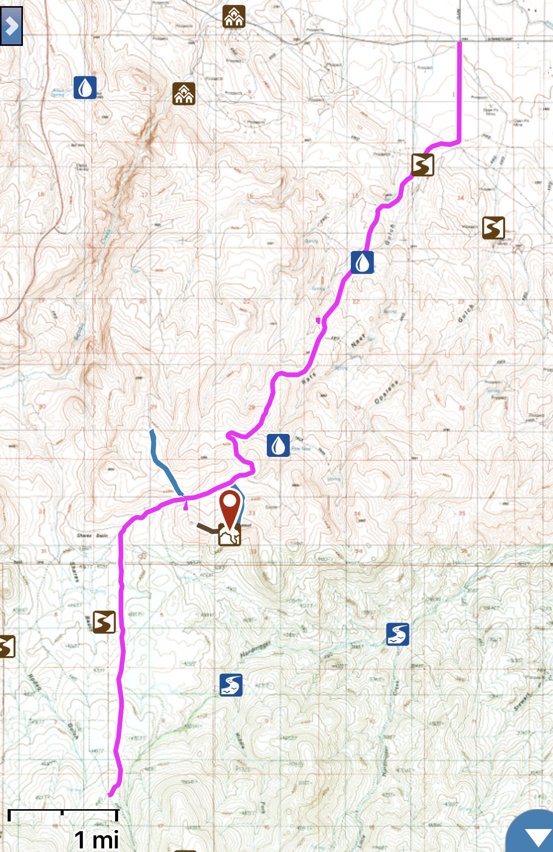
The pink GPS track shows the Coyote Grade Road access route for Dryden Peak and Piute Butte from the Clark Road/Summer Camp Road junction.
East Face Route, Class 3
From the gate, you have two options to reach the East Face Route. First, assuming access is allowed, you can follow the road into Rodeo Gulch. Second, you can follow (on foot) the east side of the fence south to the southern boundary of the private property. This spot is marked by a fence running down into the gulch. Cross the fence, which continues to run south at this point, and drop down into Rodeo Gulch. The West Ridge route starts at this point.
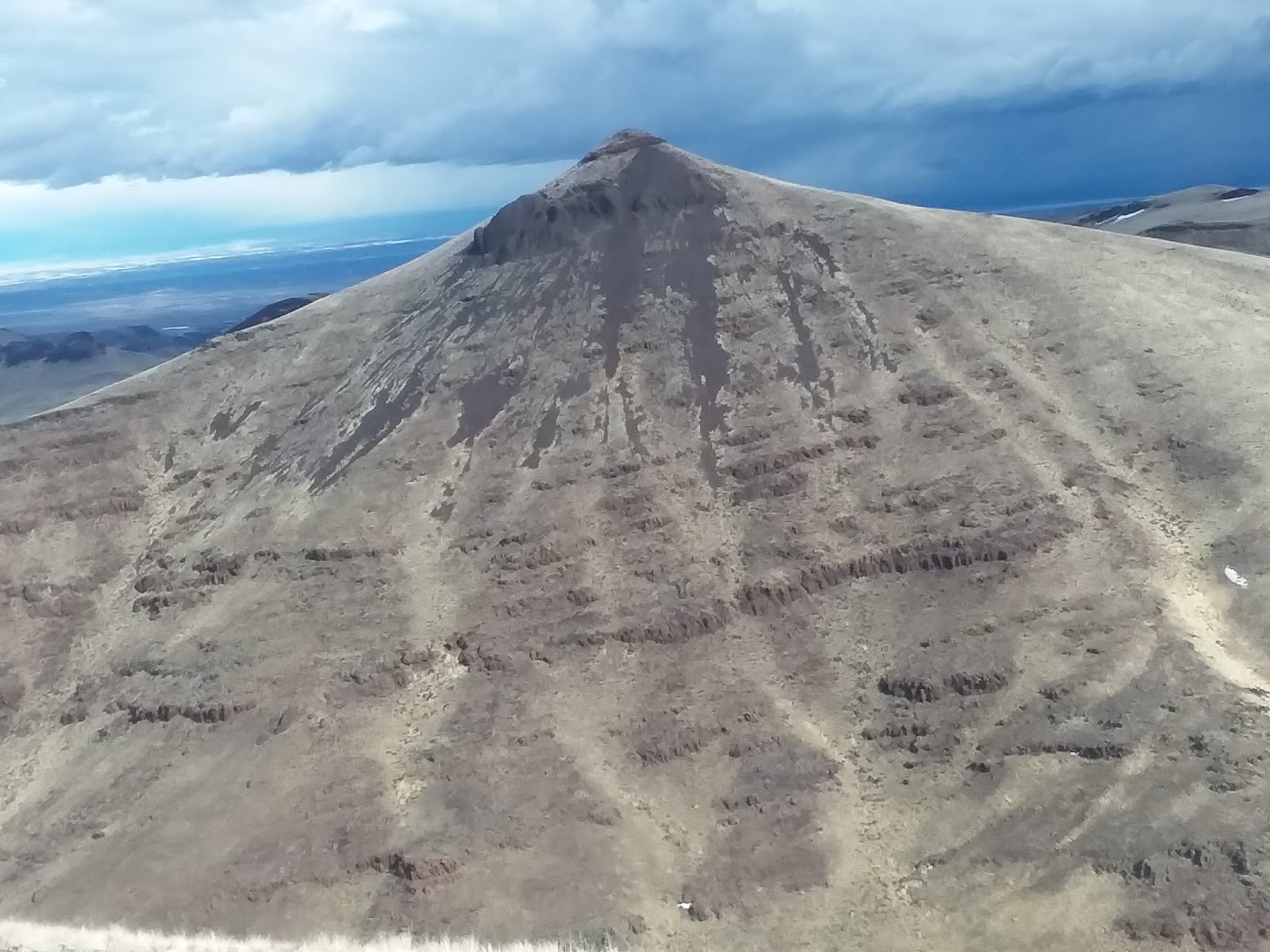
Dryden Peak’s West Face as viewed from Point 5440.
Follow the road up the gulch past a couple of water troughs. Stay on the road until, at the 5,000-foot contour, it makes a left turn and drops down a short distance. Leave the road at this spot and follow the fence uphill in a southwesterly direction. You will have crossed the fence at some point, so keep your eyes open for a spot where the lowest wire is high off the ground and scoot under the fence when you find a good spot.
Continue following the fence line to Point 5440. From this point, cross the shallow saddle moving west to the base of the east face. There is a ring of short cliffs just below the summit. Aim for the center of the face where the cliff is only about 4 feet high. One short Class 3 move takes you up to the final slopes. From Rodeo Gulch, it is 2.6 miles and roughly 900 feet of elevation gain to the summit.
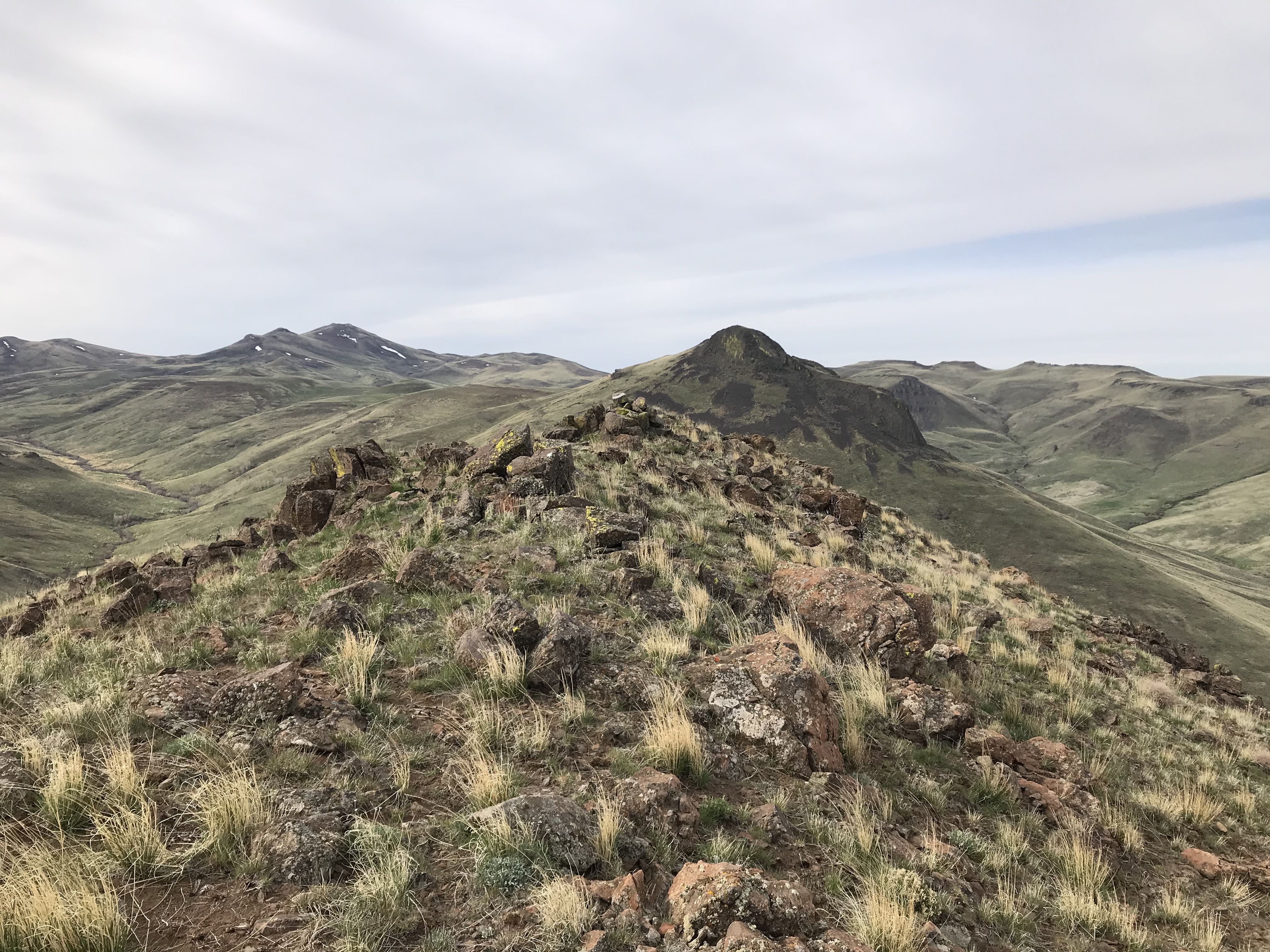
Dryden Peak’s summit looking south to Piute Butte.
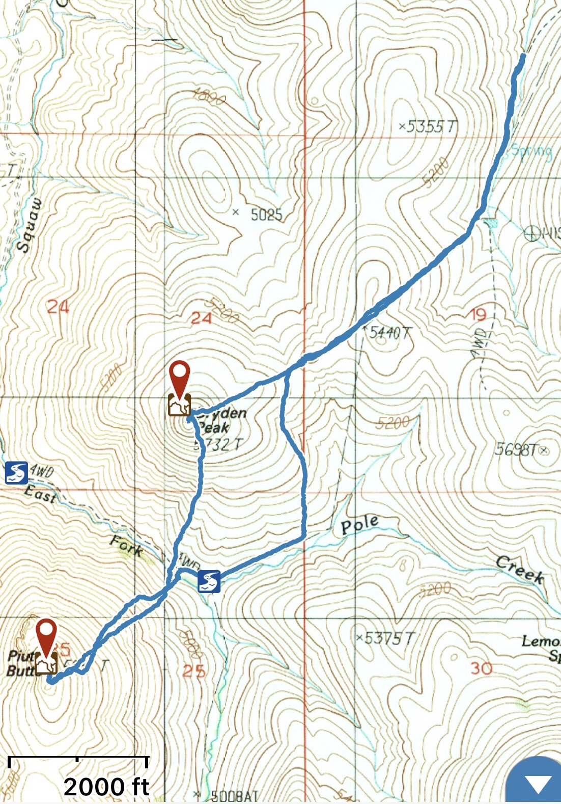
My GPS track for Dryden Peak and Piute Butte.
Additional Resources
Regions: Owyhee Mountains->SOUTHERN IDAHO
Mountain Range: Owyhee Mountains
Year Climbed: 2018
Longitude: -116.87459 Latitude: 43.31769