Elevation: 9,818 ft
Prominence: 1,118
This peak is not in the book. Rick Baugher suggests the name Headwaters Peak for this summit. His trip report is linked below. In the report, he explains the reasoning behind the name and provides an alternative route to the summit. Published November 2022
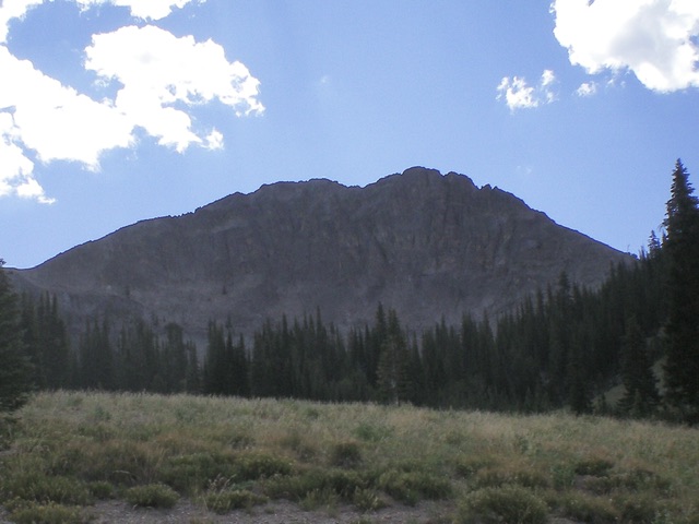
Peak 9818 is located just east of the head of Frenchman Creek in the Sawtooth Range south of Stanley. It is an impressive summit with a wicked northwest face. Peak 9818 is most easily climbed from the Frenchman Creek drainage via its Class 2 northeast ridge. USGS Frenchman Creek
Peak 9818 and its northwest face. The Class 2 northeast ridge is the skyline left of center, my descent route. The Class 4 west ridge is the skyline right of center, my ascent route. Livingston Douglas Photo
Access
Same as for Peak 9495. This is the final leg of a 5-peak adventure that includes Peak 9495, Peak 9303, Peak 9599, Peak 9540, and Peak 9818.
West Ridge, Class 4
The Climb
From the 8,980-foot connecting saddle with Peak 9540, scramble east up a steep, semi-forested ridgeline (with lots of ridge pines) to reach open, cairned Point 9407. Point 9407 is at the northwest end of a flat, narrow ridge section. Head right/southeast from Point 9407 and work along the forested ridge, dropping 45 feet to a small saddle. What faces you here is not pretty. The northwest face of Peak 9818 is a sheer cliff face and the west ridge looks impossible.
From the minor saddle/notch, scramble southeast then east up loose scree/gravel that is quite steep but has a goat trail in it. This gets you up to the base of the steep face/ridge rock, only 250 vertical feet below the summit. The face rock is simply too steep, so contour right/southwest to reach the crest of the west ridge with relative ease. Once on the crest of the west ridge, the task ahead is ominous. The rock is solid but is very steep and exposed (Class 4).
The ridge blocks are solid but the ledges on the sides of the ridge are unreliable. Most of the west ridge is Class 3 but there are several Class 4 moves required in the ridge gaps and up the steepest ridge blocks. The finish to the summit is easy Class 2 work on flatter, loose talus/scree. When climbing the west ridge, about 1/3 of the way up there is a scree gully to the right/south which is an alternative Class 2 option if necessary. The summit of Peak 9818 is small but open and has a decent summit cairn.
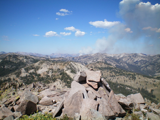
The summit cairn atop Peak 9818 with the Ross Fork Fire in the distance. That fire would come all the way here in two days and scorch the Smiley Creek Valley. Livingston Douglas Photo
Northeast Ridge/North Gully, Class 2
The Descent
From the summit, descend northeast down a ridge of somewhat-steep, loose scree, skirting a few rocky ridge outcrops high up. You will quickly reach a gentle saddle in forested terrain. From the 9,380-foot saddle, descend west then northwest down a forested drainage, seeking patches of open terrain whenever possible. Lower down, in an open area of scrub, the drainage narrows, steepens, and heads into a forest. Leave the drainage here and contour onto a forested shoulder on its left/west side. The shoulder is dense forest and has blowdown but it goes better than the [now wet] drainage.
Unfortunately, the shoulder ends in the gully at a lower elevation. Once back in the gully, move to its right/east side and contour in open sagebrush onto a face. Descend to open terrain near the Frenchman Creek drainage well below. When the open terrain ends, cross to the left/west side of Frenchman Creek and descend a final patch of forest to reach the top of Frenchman Creek Road my parking spot at the road closure and the nearby campsite.
Additional Resources
Mountain Range: Sawtooth Range
First Ascent Information:
- Other First Ascent: West Ridge, Class 4
- Year: 2022
- Season: Summer
- Party: Livingston Douglas
Longitude: -114.78049 Latitude: 43.80049