Elevation: 8,860 ft
Prominence: 720
This peak is not in the book. Margo Mandella authored the initial page for this peak. Livingston Douglas added two new routes and additional photos. Whichever route you choose, make sure you read Livingston’s Map Error section which points out significant errors on the maps you may use. Updated January 2023
Northwest Ridge Route by Margo Mandella
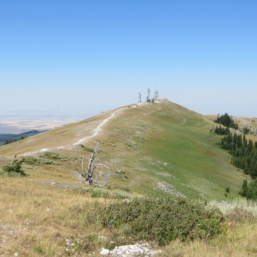
Ryan Peak sits nearly due west of Driggs, Idaho, in the Big Hole Mountains of the Targhee National Forest. Access Ryan Peak from the northwest via Relay Ridge. The summit of Ryan Peak exists as a high point along Relay Ridge. This ridge is named for several communication towers located both on the summit and along the ridge. While you are there, climb nearby Peak 8692. USGS Garns Mountain
Access
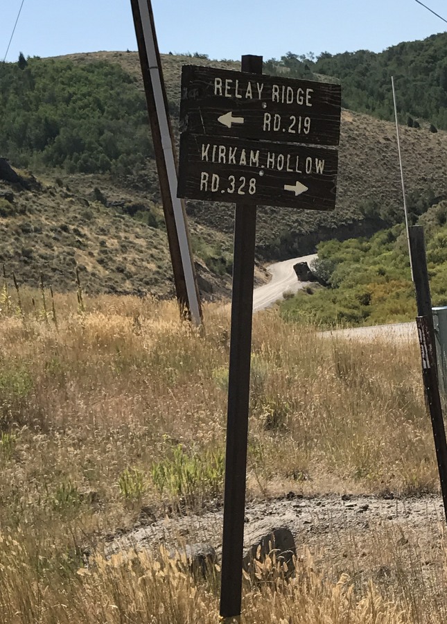
Sign for Relay Ridge Road. Margo Mandella Photo
From ID-33, turn south on Canyon Creek Road and continue on the paved road as it parallels the canyon to Green Canyon Hot Springs (which is fed by nearby Pincock Springs).
Farther past these springs, find the signed intersection and the gravel road to Relay Ridge (FSR-219) which heads east. Take this road, as it winds, climbs, switchbacks, and passes through Packsaddle Basin before it ends at a turnaround just southwest of the true summit of Ryan Peak. Park at the turnaround.
If you cannot make it to the turnaround, there are a few small areas along Relay Ridge Road to pull over and park. However, stopping short of Relay Ridge itself will result in a substantially longer climb.
A high-clearance vehicle provides the best travel as the road is steep and may be rutted in places. We have 4WD but did not use it. That said, we saw a rented Toyota Corolla at the top. However, its driver was apprehensive about the descent, so consider a more substantial vehicle than a sedan.
Northwest Ridge, Class 1

A cow and its calf crossing Relay Ridge on Ryan Peak. Steve Mandella photo.
If you don’t make it to the turnaround, you can hike along the road. We didn’t see any hikers on the road and we passed several vehicles. Use caution if hiking along the road. While it is hike-able, it is steep and obscured with vegetation in places. Motorists may not see you and are not accustomed to encountering hikers.
From the turnaround, hike the few yards to the true summit, which is an obvious high point behind the communications towers and maintenance building.
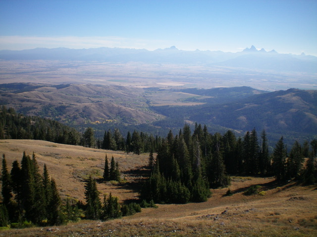
From the summit and along the entire ridge, the view of the Teton Mountains to the east is superb. Also enjoy views of nearby Peak 8692, Idaho Ridge, Mount Manning, Temple Peak, Garns Mountain, and other Big Hole peaks in the distance. Exceptional moose habitat lies in the surrounding valleys. We were lucky and saw a cow moose and calf crossing over Relay Ridge right in front of us!
Southeast Ridge and East Face/East Shoulder/Superior Creek by Livingston Douglas
Ryan Peak is located on a high ridgeline west of Horseshoe Creek. The peak sits at the head of Bell Creek and Superior Creek. It also sits above Packsaddle Basin to its north. Ryan Peak is most easily reached from jeep roads to its north.
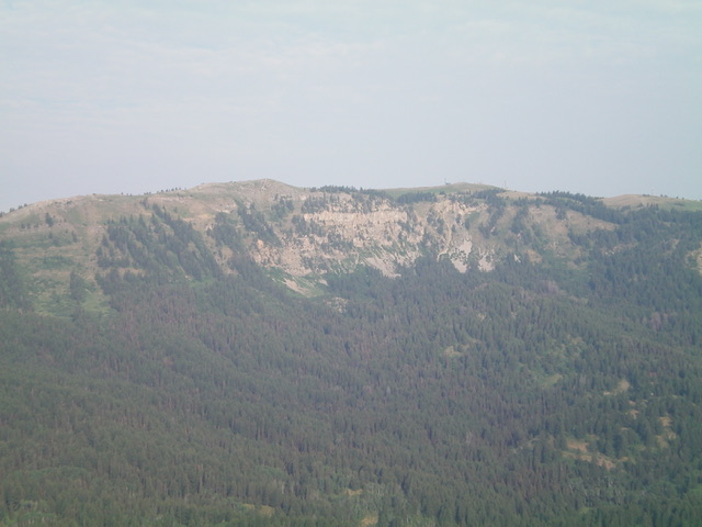
Ryan Peak (summit is just right of center) and its rugged east face as viewed from Mount Manning to its east. Livingston Douglas Photo
Access
Same as for Peak 8692. This is the second leg of a 2-peak adventure that includes Peak 8692 and Ryan Peak. This area is a mix of private and public land, so be careful. The routes described are entirely on National Forest Land.
Map Errors
There are numerous critical map errors on the USGS topo map. First, it shows a road (FSR-235B) heading south from Horseshoe Creek Road no longer exists. Second, the pack trail heading up Bell Creek no longer exists. The first section of that trail is now FSR-219 but only goes a short distance and then crosses a shoulder to the east. Third, FST-219/South Horseshoe Creek Trail is not shown on the map. Fourth, there is a trail heading up Superior Creek to the Superior Mine, but it is located on the north side of the creek not the south side. In addition, that trail is blocked by posted, private land partway up Superior Creek. The Targhee National Forest map is much more accurate in this area.
Southeast Ridge, Class 2
The Climb
This climb is mostly Class 1. From the 8,340-foot connecting saddle with Peak 8692, follow FST-225 (an ATV trail) northwest up the ridge crest and over the [lower] southeast summit of Ryan Peak (Point 8800+). The trail then drops 65 vertical feet to a narrow saddle then continues northwest to reach the antenna-clad summit of Ryan Peak. Leave the trail and scramble a short distance right/east to reach the high point on the ridge crest. The high point of Ryan Peak is a minor ridge hump near the southernmost antenna facility. I built a small cairn atop this high point.
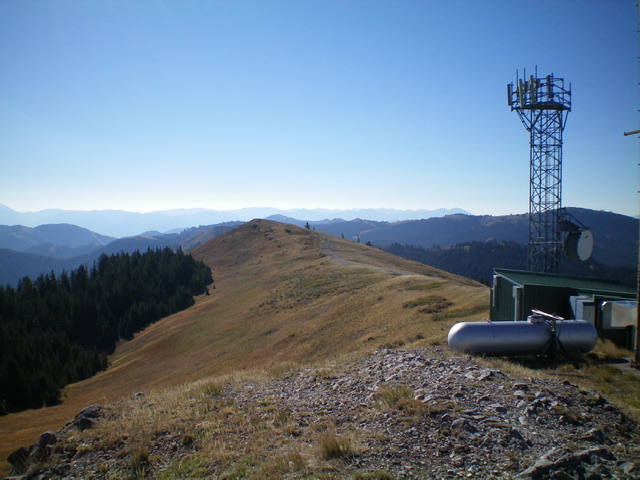
Looking south from the summit of Ryan Peak. Point 8800+ is the hump just left of center. Livingston Douglas Photo
Looking northeast down into Horseshoe Creek Valley from the summit of Ryan Peak. Livingston Douglas Photo
East Face/East Shoulder/Superior Creek, Class 2
The Descent
From the summit, descend an easy scrub slope north then northeast down through a short patch of pine forest to reach a dry gully. Follow this gully east then southeast down a steep section then leave it to bushwhack laterally rightward over onto the not-so-obvious east shoulder where the private homes are located.
The contouring (and rightward diagonal descent) is thick with brush and is difficult. Persevere to reach the forested east shoulder. The shoulder has some ups and downs and is not well-defined high up. Find a good trail heading right/south off the ridge just before reaching the highest of the private homes. This use trail is not shown on any maps. It drops to the Superior Creek drainage and heads east. It then bends left/north to head toward the Superior Mine. Before reaching the mine, the trail reaches a patch of private property (shown on land management maps). This property has a gated fence where the trail crosses from National Forest Land onto private property. The private property is aggressively posted.
Leave the trail here and bushwhack northeast through a thick mess of brush and forest in a flat area of the Superior Creek drainage. Move onto a forested shoulder (of sorts) on the right/south side of the brushy drainage. When it soon flames out, pick up a good foot trail in a large open meadow. This unofficial trail is the old Superior Creek Trail and is on the north side of the creek. Follow the trail northeast to its unsigned junction with FST-219 just left/west of the Superior Creek log crossing. Hike ¾ mile back to the trailhead and the large parking area.
Additional Resources
Regions: Big Hole and Snake River Mountains
Mountain Range: Big Hole and Snake River Mountains
Longitude: -111.3447 Latitude: 43.7069